Mild And Windy; Showers/Storms Return Tomorrow
ON THE MAPS: A vigorous storm system is developing west of the state this morning as a cold core upper trough lifts out of the Southwest U.S. A very deep surface low, with a central pressure down to near 970 mb (28.64″), develops over western Kansas. North and west of that low, blizzard conditions are likely with hurricane force wind gusts, and south and east of the low severe storms will form. SPC has an “enhanced risk” of severe weather defined today along the Mississippi River from north of Memphis down to near Greenville, MS.
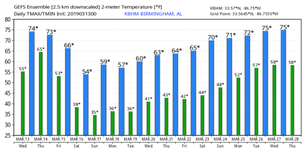
Here in Alabama today, we stay dry; the day will feature a mix of sun and clouds with a high in the 70s. The pressure gradient will tighten, and southeast winds will increase to 15-25 mph by afternoon, with gusts to 30 mph at times.
SHOWERS/STORMS RETURN TOMORROW: The surface low moves north to Iowa tomorrow, while slowly weakening. The trailing cold front will move in our direction and bring showers and thunderstorms into the state. The main upper air support will be north of Alabama, but the front could bring a few strong to severe storms to the state late in the day and tomorrow night.
SPC has defined a “slight risk” (level 2/5) of severe thunderstorms west of a line from Huntsville to Dora to Northport, and a “marginal risk” (level 1/5) is as far east as Gadsden, Clanton, Selma, and Jackson.
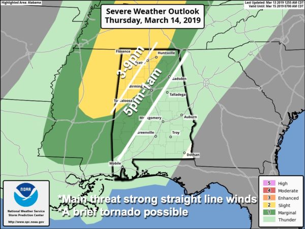
TIMING: Although some rain is possible tomorrow morning, the window for the heavier storms over the “slight risk” area (North and West Alabama) will come from 3 until 9 p.m. For Central Alabama, the strong storms are possible from 5pm until just after midnight.
THREATS: Stronger storms could produce strong gusty winds and small hail. A brief tornado is possible as well, mainly in the “slight risk” area.
GRADIENT WINDS: Away from thunderstorms, the day will be windy due to the tight pressure gradient (much like today). South winds will average 12-25 mph, with gusts to 30 mph at times.
RAIN: Rain amounts of around one inch are expected tomorrow; we are not expecting any flooding issues.
FRIDAY AND THE WEEKEND: Any lingering rain will end Friday morning, and the sky becomes partly sunny by afternoon as dry air returns. Friday’s high will be in the 60-65 degree range.
The weekend will feature cold mornings with lows between 30 and 36 degrees for most communities across North/Central Alabama. Colder spots will see a freeze, and frost is likely, especially early Sunday with a calm wind. The sky will be sunny Saturday and Sunday; the high Saturday will be in the upper 50s, followed by low 60s Sunday.
NEXT WEEK: The weather looks cool and dry; lows will be in the 30s on most mornings as the risk of frost continues. Highs will be in the upper 50s Monday and Tuesday, and mostly in the 60s for the rest of the week. See the Weather Xtreme video for maps, graphics, and more details.
ON THIS DATE IN 1990: Thunderstorms produced severe weather from northwest Texas to Wisconsin, Iowa, and Nebraska during the day and into the night. Severe thunderstorms spawned 59 tornadoes, including twenty-six strong or violent tornadoes, and there were about two hundred reports of large hail or damaging winds. There were forty-eight tornadoes in Kansas, Nebraska, and Iowa, and some of the tornadoes in those three states were the strongest of record for so early in the season, and for so far northwest in the United States. The most powerful tornado of the day was one that tore through the central Kansas community of Hesston. The F5 tornado killed two persons, injured sixty others, and caused 22 million dollars damage along its 67-mile path.
WEATHER RADIO PROGRAMMING IN JACKSONVILLE: We will be in Jacksonville next Monday night, March 18, programing weather radios. Bring your weather radio and we will check it for you; we will be on the 5th floor of JSU Stadium from 4:00 until 6:30 p.m. I will be there doing weather live on ABC 33/40.
BEACH FORECAST: Click here to see the AlabamaWx Beach Forecast Center page.
WEATHER BRAINS: Don’t forget you can listen to our weekly 90 minute show anytime on your favorite podcast app. This is the show all about weather featuring many familiar voices, including our meteorologists here at ABC 33/40.
CONNECT: You can find me on all of the major social networks…
Facebook
Twitter
Instagram
Pinterest
Snapchat: spannwx
I have a weather program this morning at Oneonta Middle School… look for the next Weather Xtreme video here by 4:00 this afternoon. Enjoy the day!
Category: Alabama's Weather, ALL POSTS, Weather Xtreme Videos
About the Author (Author Profile)
James Spann is one of the most recognized and trusted television meteorologists in the industry. He holds the AMS CCM designation and television seals from the AMS and NWA. He is a past winner of the Broadcast Meteorologist of the Year from both professional organizations.Subscribe
If you enjoyed this article, subscribe to receive more just like it.


