Strong/Severe Storms Possible Late Tomorrow/Tomorrow Night
MILD, WINDY AFTERNOON: Temperatures are in the 70s across the great state of Alabama this afternoon with a mix of sun and clouds. While our weather is calm here, we are watching a very deep surface low over Kansas… the pressure has dropped to 972 mb, or 28.70″ of mercury. A blizzard is in progress at Denver; winds at DIA have gusted to 80 mph. Blizzard warnings are in effect across the High Plains, and south and east of the surface low, in the warm sector, showers and storms continue to develop.

STRONG STORMS LATE TOMORROW: The surface low will slowly fill tomorrow… it should be over Iowa by afternoon. As the trailing front approaches, showers and storms will slowly increase across Alabama. SPC maintains a “slight risk” (level 2/5) of severe thunderstorms west of a line from Huntsville to Tuscaloosa to Emelle, and a “marginal risk” (level 1/5) as far east as Gadsden, Calera, Camden, Jackson.
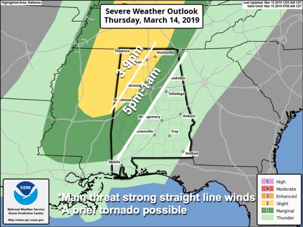
TIMING: While a few strong storms could form during the afternoon, the latest high resolution model output really suggests the main threat for severe thunderstorms will come tomorrow night, after 6:00 p.m. Storms should weaken after midnight as the main upper support continues to lift away from us.
THREATS: Stronger storms tomorrow night will be capable of producing strong, gusty winds, small hail, and possibly an isolated tornado or two. Highest tornado threat is over Northwest Alabama in the “slight risk” area.
GRADIENT WINDS: During the day, even with no thunderstorms involved, we will experience south winds averaging 12-25 mph, with gusts to 30 at times, due to the tight pressure gradient.
RAIN: Rain amounts tomorrow and tomorrow night will be around one inch… we don’t expect any flooding issues.
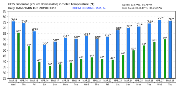
FRIDAY AND THE WEEKEND: For the northern half of Alabama, lingering rain will end Friday morning, and the sky becomes partly sunny by afternoon. But, rain could continue into the afternoon over the southern half of the state. The day will be cooler with a high in the 60-65 degree range.
The weekend will be dry, but temperatures will be below average. Lows will be well down in the 30s Saturday and Sunday morning; the most widespread frost will most likely come early Sunday when the wind will be near calm. Colder spots will drop into the 20s over the northern half of the state. The sky will be sunny both days with a high not too far from 60 degrees.
NEXT WEEK: For now the entire week looks dry for Alabama. Lows will remain in the 30s Monday and Tuesday, followed by 40s Wednesday through Friday morning. Highs throughout the week will be mostly in the 60s… See the Weather Xtreme video for maps, graphics, and more details.
ON THIS DATE IN 1990: Thunderstorms produced severe weather from northwest Texas to Wisconsin, Iowa, and Nebraska during the day and into the night. Severe thunderstorms spawned 59 tornadoes, including twenty-six strong or violent tornadoes, and there were about two hundred reports of large hail or damaging winds. There were forty-eight tornadoes in Kansas, Nebraska, and Iowa, and some of the tornadoes in those three states were the strongest of record for so early in the season, and for so far northwest in the United States. The most powerful tornado of the day was one that tore through the central Kansas community of Hesston. The F5 tornado killed two persons, injured sixty others, and caused 22 million dollars damage along its 67-mile path.
WEATHER RADIO PROGRAMMING IN JACKSONVILLE: We will be in Jacksonville next Monday night, March 18, programing weather radios. Bring your weather radio and we will check it for you; we will be on the 5th floor of JSU Stadium from 4:00 until 6:30 p.m. I will be there doing weather live on ABC 33/40.
BEACH FORECAST: Click here to see the AlabamaWx Beach Forecast Center page.
WEATHER BRAINS: Don’t forget you can listen to our weekly 90 minute show anytime on your favorite podcast app. This is the show all about weather featuring many familiar voices, including our meteorologists here at ABC 33/40.
CONNECT: You can find me on all of the major social networks…
Facebook
Twitter
Instagram
Pinterest
Snapchat: spannwx
I enjoyed seeing the sixth graders this morning at Oneonta Middle School… be looking for them on the Pepsi KIDCAM today at 5:00 on ABC 33/40 News! The next Weather Xtreme video will be posted here by 7:00 a.m. tomorrow…
Category: Alabama's Weather, ALL POSTS, Weather Xtreme Videos
About the Author (Author Profile)
James Spann is one of the most recognized and trusted television meteorologists in the industry. He holds the AMS CCM designation and television seals from the AMS and NWA. He is a past winner of the Broadcast Meteorologist of the Year from both professional organizations.Subscribe
If you enjoyed this article, subscribe to receive more just like it.


