

Weather Xtreme: Scattered Storms Later Today, Mainly Dry For Much Of Sunday
SEVERE WEATHER OUTLOOK FOR THE WEEKEND & MONDAY
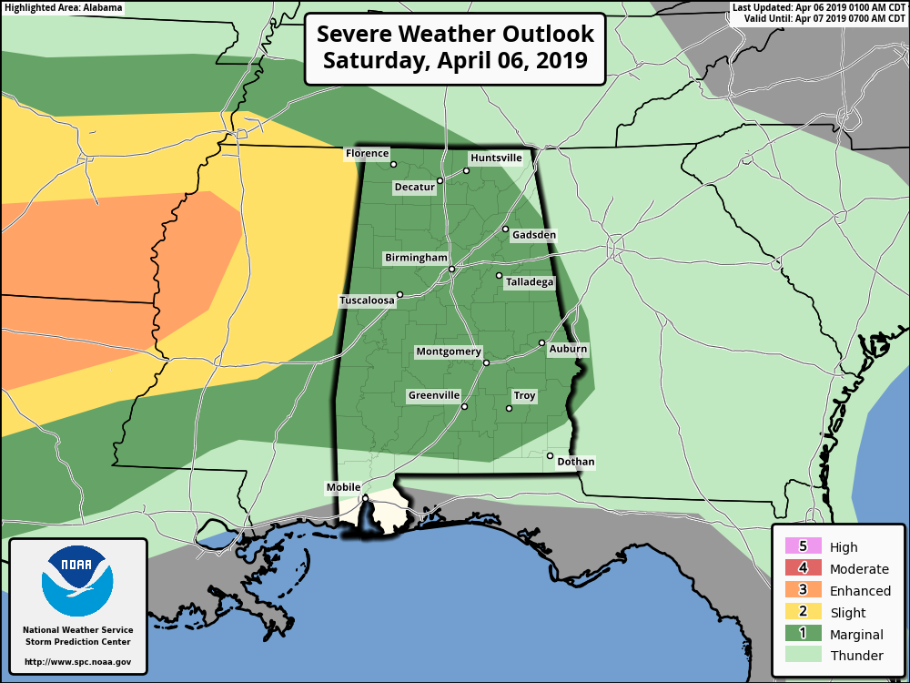
Severe weather outlook for today shows nearly all of Central Alabama has been placed in a Marginal Risk for severe storms, mainly for isolated damaging wind gusts up to 60 MPH and hail up to 1-inch in diameter.
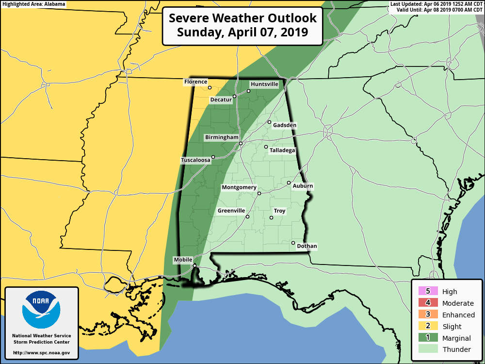
On Sunday, we have a Slight Risk for locations in the northwestern parts of the area, mainly from Hackleburg (Marion Co.) to Vernon (Lamar Co.) and points west. A Marginal Risk extends out from that to a line from Snead (Blount Co.) to Birmingham to Marion (Perry Co.).
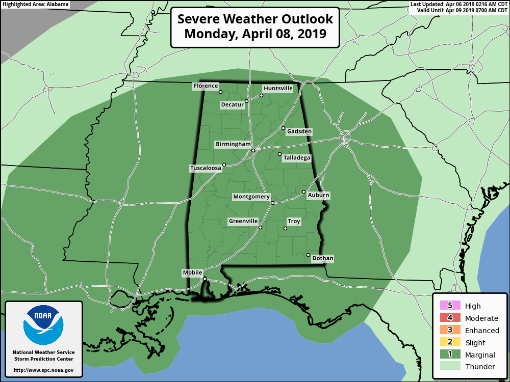
And on Monday, all of Central Alabama has been placed in a Marginal Risk for severe storms.
SATURDAY’S WEATHER
We have troughing out in the west with a decent ridge over the southeast that is pushing warm and moist air up from the south, which will lead to instability during the heating of the day. Along with that, we’ll have a warm front that will be pushing northward through the area today. With highs topping out in the upper 70s to the lower 80s and dewpoints in the mid to upper 60s by the late afternoon hours, we have the potential for some scattered thunderstorms to develop with the heating of the day and persist through the evening. A few of these storms have the potential to become strong to marginally severe with isolated damaging winds and quarter-size hail as the threats. The window for the potential of strong to severe storms will be from 1:00 pm to 7:00 pm for the southern half of the area, and from 5:00 pm to 12:00 am for the northern half. Showers and thunderstorms will remain likely for the overnight hours with lows in the lower to mid-60s.
SUNDAY’S WEATHER
The daytime hours on Sunday look to be dry for much of Central Alabama as any isolated to scattered afternoon thunderstorm activity will be limited to the extreme western locations and in the southeastern corner of the area. We’ll have partly to mostly cloudy skies with highs reaching the upper 70s to the lower 80s. Sunday night, the troughing moves closer to the state and a low will be stationed over eastern Texas which will send thunderstorms into the area through the late night and overnight hours. We’ll have the potential for strong to severe storms for the western half of the area with isolated damaging wind gusts up to 60 MPH as the main threat. Lows will be in the lower to mid-60s.
MONDAY’S WEATHER
The low creeps even closer to the state on Monday, continuing to keep us in an unstable airmass with showers and thunderstorms likely throughout the day. Once again, some of the storms throughout the day could be strong to marginally severe with isolated damaging wind gusts up to 60 MPH being the main threat. Highs will be cooler with the cloud cover and rain, only reaching the lower to mid-70s.
TUESDAY’S WEATHER
The low finally makes it into the southwestern parts of the state on Tuesday which will keep us continuing with the chance of scattered showers and thunderstorms, but at this point, no severe weather is expected. Highs will start to rebound and will be back up in the mid to upper 70s.
WEDNESDAY’S WEATHER
Wednesday will be a sunny and warm day across the area. Afternoon highs topping out in the lower to mid-80s.
THURSDAY’S WEATHER
Much of the day on Thursday will be nice and warm, but an impulse moving through the area could bring a squall line of storms during the evening and overnight hours. At this point, warm air aloft looks to provide a cap on the atmosphere which may limit that activity. We’ll have a better idea as we get closer. Highs reach the upper 70s to the mid-80s.
FRIDAY’S WEATHER
Much cooler weather can be expected on Friday with clearing skies. Afternoon highs will only be in the upper 60s to the mid-70s across the area.
HONDA INDY GRAND PRIX OF ALABAMA
It’s not too late to get your tickets… The Honda Indy Grand Prix of Alabama continues this weekend at the beautiful Barber Motorsports Park! Make plans for the event that has been voted “Best Annual Event” & “Best Sporting Event” in Birmingham. Kids 15 & under are admitted free with a ticketed adult. Pack a picnic/cooler and bring the family out for a weekend full of activities and racing! For tickets, CLICK HERE.
BEACH FORECAST CENTER
Get the latest weather and rip current forecasts for the beaches from Fort Morgan to Panama City on our Beach Forecast Center page. There, you can select the forecast of the region that you are interested in.
ALREADY OFF TO A HOT START IN 2019! ADVERTISE WITH THE BLOG!
We have enjoyed over 6 MILLION page views on AlabamaWx.com so far in 2019! Don’t miss out! We can customize a creative, flexible and affordable package that will suit your organization’s needs. Contact Bill Murray at (205) 687-0782.
E-FORECAST
Get the Alabama Wx Weather Blog’s Seven-Day Forecast delivered directly to your inbox by email twice daily. It is the most detailed weather forecast available in Central Alabama. Subscribe here… It’s free!
CONNECT WITH THE BLOG ON SOCIAL MEDIA
You can find the AlabamaWx Weather Blog on the major social media networks:
Facebook
Twitter
Instagram
WEATHERBRAINS
Don’t forget you can listen to our weekly 90 minute netcast anytime on the web at WeatherBrains.com or on iTunes, Stitcher, or Spotify. This is the show all about weather featuring many familiar voices, including the meteorologists at ABC 33/40.
Category: Alabama's Weather, ALL POSTS, Severe Weather, Weather Xtreme Videos
About the Author (Author Profile)
Scott Martin is an operational meteorologist, professional graphic artist, musician, husband, and father. Not only is Scott a member of the National Weather Association, but he is also the Central Alabama Chapter of the NWA president. Scott is also the co-founder of Racecast Weather, which provides forecasts for many racing series across the USA. He also supplies forecasts for the BassMaster Elite Series events including the BassMaster Classic.Subscribe
If you enjoyed this article, subscribe to receive more just like it.


