More Strong Storms Later Today
ACTIVE DAY: A severe storm produced possible tornado damage early this morning over northern Blount, and parts of Marshall counties… that storm is out of the state and there is no severe weather in progress as of 8:00 a.m.
Later today, more strong to severe storms are possible. SPC has defined slight risk (level 2/5) for roughly the northern half of the state, with a marginal risk (level 1/5) for the southern counties.
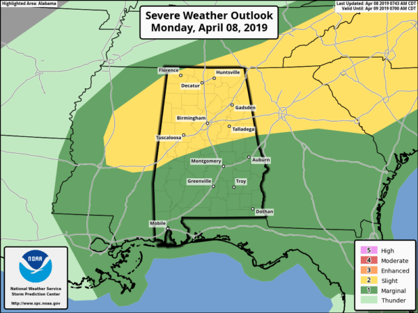
The main threat from storms that form later today will come from hail and strong gusty winds. But, an isolated tornado can’t be ruled out, mainly in the slight risk area over North Alabama this afternoon and early tonight.
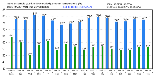
Away from the storms, the day will be mostly cloudy with a high in the 70s.
TOMORROW: We will maintain the chance of lingering showers tomorrow, mostly during the morning hours. Clouds will linger through the afternoon, and the high will remain well up in the 70s.
WEDNESDAY THROUGH FRIDAY: Wednesday and Thursday will be warm and dry with ample sunshine along with a high in the low 80s. A cold front will bring a chance of showers, and possibly a thunderstorm, Thursday night or early Friday morning. For now moisture seems to be very limited, and severe storms are not expected. Then, we expect partial clearing Friday afternoon with a high in the upper 70s.
THE ALABAMA WEEKEND: Another weather system will bring rain and storms to the state over the weekend. Rain is possible Saturday, and we will have a chance of stronger thunderstorms Saturday night into Sunday. Too early to define a sever weather risk due to model inconsistency… See the Weather Xtreme video for maps, graphics, and more details.
ON THIS DATE IN 1998: A powerful EF-5 tornado tore through the western suburbs of Birmingham, impacting communities like Oak Grove, Rock Creek, Sylvan Springs, McDonald Chapel, and Pratt City. The death toll was 32 in Jefferson County, with more than 250 injuries. More than 1000 homes were destroyed and more than 900 homes with significant damage. The same parent thunderstorm dropped another tornado in St. Clair County (rated EF-2) that killed two people north of Pell City at Wattsville.
BEACH FORECAST: Click here to see the AlabamaWx Beach Forecast Center page.
WEATHER BRAINS: Don’t forget you can listen to our weekly 90 minute show anytime on your favorite podcast app. This is the show all about weather featuring many familiar voices, including our meteorologists here at ABC 33/40.
CONNECT: You can find me on all of the major social networks…
Facebook
Twitter
Instagram
Pinterest
Snapchat: spannwx
I have a weather program this morning at the Alabaster Public Library… look for the next Weather Xtreme video here by 4:00 this afternoon… keep an eye on the blog for updates….
Category: Alabama's Weather, ALL POSTS, Weather Xtreme Videos
About the Author (Author Profile)
James Spann is one of the most recognized and trusted television meteorologists in the industry. He holds the AMS CCM designation and television seals from the AMS and NWA. He is a past winner of the Broadcast Meteorologist of the Year from both professional organizations.Subscribe
If you enjoyed this article, subscribe to receive more just like it.


