

Warmest Day So Far This Year Tomorrow
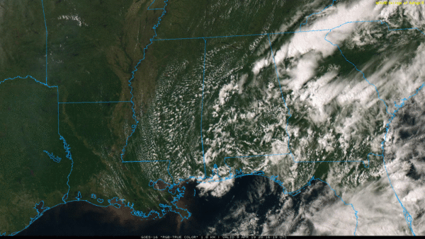
RADAR CHECK: A few lingering showers and thunderstorms are over Alabama this afternoon, but for most of the state the sky has become partly sunny. Temperatures are mostly in the mid 70s. Scattered showers will end this evening, and the sky will be mostly fair tonight.
WARM DAYS AHEAD: We project a high in the mid 80s tomorrow with a sunny sky; it will be the warmest day so far this year for most of Alabama. Birmingham’s warmest temperature so far is 82 recorded this past Sunday (April 7). Thursday will be a partly sunny day with a high in the low 80s. Then, on Friday, we will bring in a chance of showers with a cold front drifting down into the state. The front will be working with limited upper support and not much moisture, so no worries with severe storms, and rain amounts should be fairly light. The high Friday will be in the upper 70s.
STORMY WEEKEND AHEAD: The front will lift northward through Alabama as a warm front. This will bring some rain to the state, but it won’t rain all day. It is almost impossible to forecast placement and timing of the rain this far out, but for now it looks like the best chance of rain for South Alabama will come early in the day, and over North Alabama during the midday hours. As the warm front continues to move northward, most places will see some sun Saturday afternoon with a high around 80 degrees.
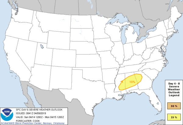
Then, a dynamic weather system will bring showers and storms to the state late Saturday night into the day Sunday. Global guidance suggests for now the main threat of severe storms will come from about 3:00 a.m. until 12:00 noon Sunday, but understand this will probably change as we get closer to the weekend. SPC has already defined a severe weather risk of much of Alabama on their “Day 6” outlook for Sunday.
It looks like all modes of severe weather will be possible, including large hail, damaging winds, and tornadoes. Be sure you church has a severe weather plan! Have a NOAA Weather Radio, someone monitoring it, and a plan of action to put people in a safe place in the event the church is in a tornado warning polygon. Now is the time to prepare.
NEXT WEEK: The first half of next week looks dry with pleasant afternoon and cool nights… highs in the 70s and lows in the 40s. See the Weather Xtreme video for maps, graphics, and more details.
ON THIS DATE IN 1953: The first radar image of a tornado was detected by radar equipment at the University of Illinois Airport at Champaign, IL. Studies of the radar pictures from that day showed that a tornado of significant size and intensity could be detected.
BEACH FORECAST: Click here to see the AlabamaWx Beach Forecast Center page.
WEATHER BRAINS: Don’t forget you can listen to our weekly 90 minute show anytime on your favorite podcast app. This is the show all about weather featuring many familiar voices, including our meteorologists here at ABC 33/40.
CONNECT: You can find me on all of the major social networks…
Facebook
Twitter
Instagram
Pinterest
Snapchat: spannwx
I had a great time today visiting with the 6th graders at Goshen Elementary in Pike County… be looking for them on the Pepsi KIDCAM today at 5:00 on ABC 33/40 News! The next Weather Xtreme video will be posted here by 7:00 a.m. tomorrow…
Category: Alabama's Weather, ALL POSTS, Weather Xtreme Videos
About the Author (Author Profile)
James Spann is one of the most recognized and trusted television meteorologists in the industry. He holds the AMS CCM designation and television seals from the AMS and NWA. He is a past winner of the Broadcast Meteorologist of the Year from both professional organizations.Subscribe
If you enjoyed this article, subscribe to receive more just like it.


