Strong/Severe Storms Possible Tomorrow Night
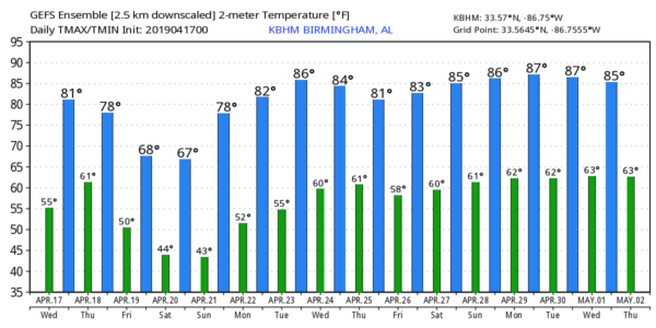
ONE MORE DRY DAY: Expect a good supply of sunshine across Alabama today with a high in the low 80s this afternoon. To the west we will be watching developments from Texas to the Great Lakes as severe storms are forecast to develop late today and tonight ahead of a potent weather system.
TOMORROW: Most of the day tomorrow will be warm and dry across Alabama, but clouds will increase, and southerly winds will increase, averaging 15-25 mph by afternoon with higher gusts. The high tomorrow will be in the upper 70s.
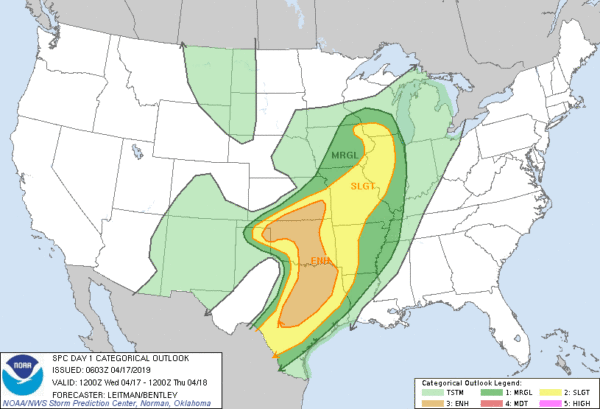
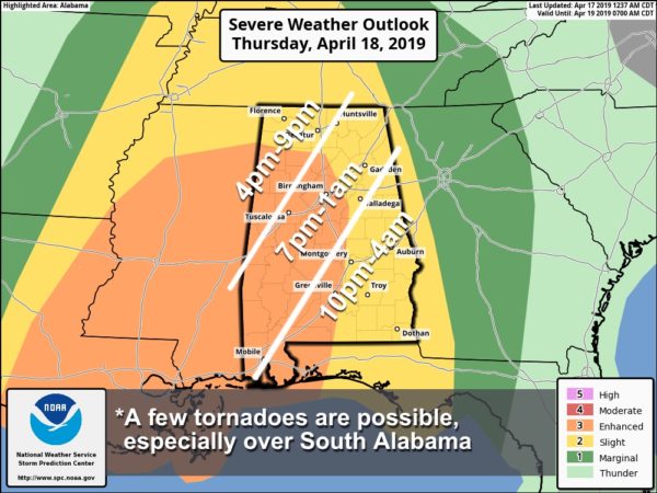
SEVERE STORMS POSSIBLE TOMORROW NIGHT: A band of strong to severe thunderstorms will push into Alabama tomorrow night. SPC has an “enhanced risk” (level 3/5) defined for parts of West and Southwest Alabama, with a “slight risk” (level 2/5) for the rest of the state.
While shear values will be very high, instability could be a limiting factor for severe storms over the northern half of the state.
TIMING: While a storm might approach the western border of Alabama as early as 4:00 tomorrow afternoon, the core threat comes tomorrow night, after 6:00. Storms will exit the state after midnight tomorrow night.
THREATS: Storms will be capable of producing strong, possibly damaging winds and a few tornadoes. The best combination of helicity and instability for tornadoes will be over the southern half of the state. The hail threat is not especially high.
RAIN: Rain amounts of around 1 inch are forecast, so no flooding issues.
This type of severe weather threat is common for Alabama in April, just be weather aware tomorrow night and have way of getting warnings if they are required. Know your safe place if you are in a tornado waring polygon, and have helmets there for everyone in the family.
FRIDAY: A deep, cold core upper low will pas right over Alabama Friday. The day will be cloudy and colder; temperatures will hold in the 50s all day with periods of rain. We might even get some small hail from light rain showers due to the very cold air aloft.
EASTER WEEKEND: The weekend will feature sunshine in full supply both days along with a warming trend. The high Saturday will be in the 65-68 degree range, followed by mid to upper 70s Sunday.
NEXT WEEK: The weather look warm and dry Monday through Wednesday. Showers and storms return Thursday, and some lingering light rain is possible Friday. The following weekend (April 27-28) looks dry and pleasant. See the Weather Xtreme video for maps, graphics, and more details.
ON THIS DATE IN 1922: Southern Illinois and Western Indiana saw two rounds of severe weather, including tornadoes. The first significant tornado occurred just before midnight on the 16 near Oakdale, Illinois. This tornado killed 4 and injured 22 others. Five additional tornadoes took place between midnight and 3 AM on the 17. During the mid-morning and early afternoon hours, two estimated F4 tornadoes caused devastation in Hedrick and near Orestes in Indiana. A postcard from one farm near Orestes was dropped near Mt. Cory, Ohio, 124 miles away.
BEACH FORECAST: Click here to see the AlabamaWx Beach Forecast Center page.
WEATHER BRAINS: Don’t forget you can listen to our weekly 90 minute show anytime on your favorite podcast app. This is the show all about weather featuring many familiar voices, including our meteorologists here at ABC 33/40.
CONNECT: You can find me on all of the major social networks…
Facebook
Twitter
Instagram
Pinterest
Snapchat: spannwx
I have a weather program this morning at Floyd Elementary in Gadsden… be looking for the next Weather Xtreme video here by 4:00 this afternoon. Enjoy the day!
Category: Alabama's Weather, ALL POSTS, Weather Xtreme Videos
About the Author (Author Profile)
James Spann is one of the most recognized and trusted television meteorologists in the industry. He holds the AMS CCM designation and television seals from the AMS and NWA. He is a past winner of the Broadcast Meteorologist of the Year from both professional organizations.Subscribe
If you enjoyed this article, subscribe to receive more just like it.


