Warm Afternoon; Showers Are Widely Scattered
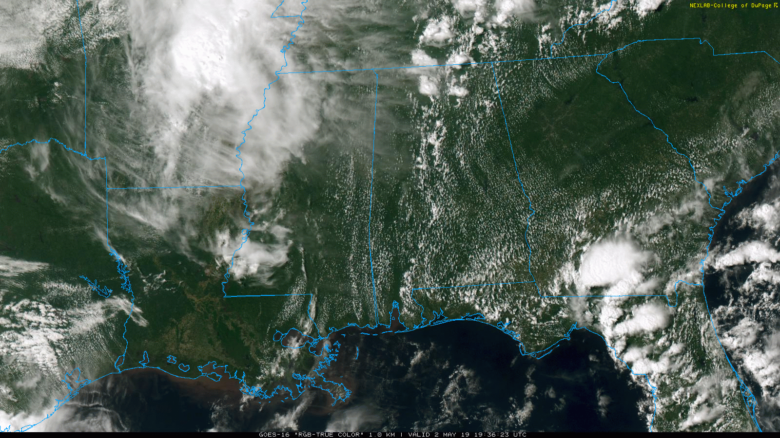
RADAR CHECK: We have a few widely scattered showers and storms over the northern half of Alabama this afternoon… they are moving north. But, most of the state is dry with a partly sunny sky. Temperatures are generally in the mid 80s… the average high at Birmingham on May 2 is 78. Showers will end early tonight, and there is only a small risk of an overnight shower.
The weather won’t change much tomorrow. We expect a mix of sun and clouds with just a few widely scattered, mostly afternoon and evening showers or storms. Most communities will stay dry, and the high will be in the mid 80s.
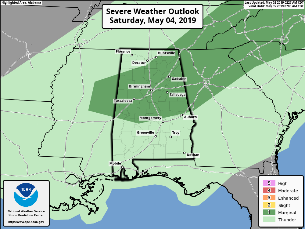
THE ALABAMA WEEKEND: A weak front will edge into far North Alabama Saturday, and there should be an increase in the number of scattered showers and storms. Still, a decent part of the day will be dry. But, where storms do form Saturday afternoon and evening, they could produce hail and strong, gusty winds. SPC has a “marginal risk” (level 1/5) defined for parts of North/Central Alabama…
The sky will be occasionally cloudy Saturday with a high in the low 80s. Drier air returns Sunday, and the sky should be partly to mostly sunny with a high in the low 80s. Any showers Sunday should be confined to far South Alabama, and even there they will be isolated.
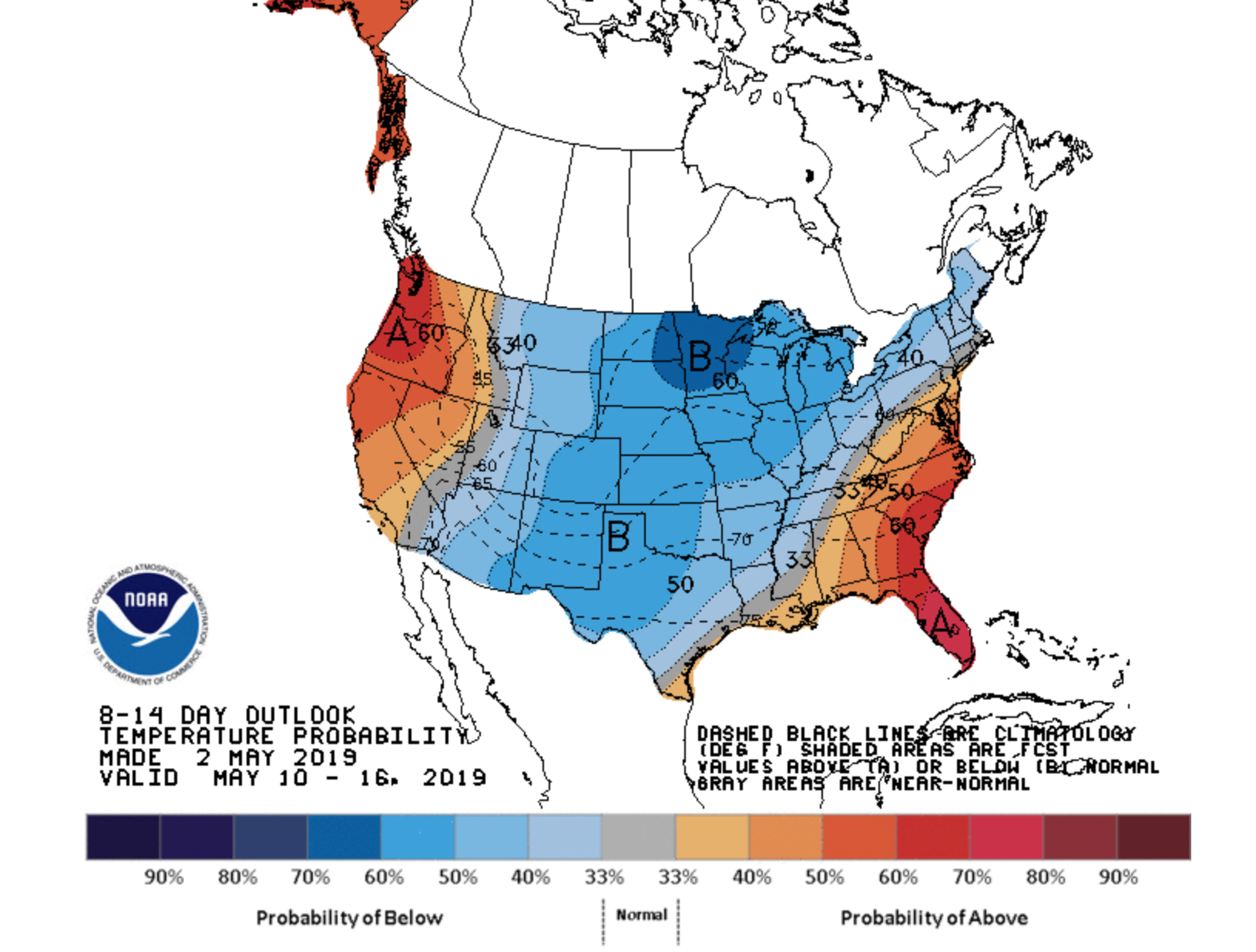
NEXT WEEK: Monday will be warm and dry… the latest global data suggests showers could return late Tuesday or Tuesday night, and then each day will have some risk of scattered showers and storms Wednesday through Friday. This is a summer-like set-up, meaning the showers will be random and scattered; nothing too widespread. Highs will remain in the 80s as the ridge holds… See the Weather Xtreme video for maps, graphics, and more details.
TROPICS: A broad disturbance around the Bahamas will curve northeast just off the Southeast U.S. coast over the next few days; NHC gives this only a 10 percent chance of becoming organized. No impact to the Florida Panhandle or the Alabama Gulf Coast.

ON THIS DATE IN 2010: May began with two days of historical rainfall over much of Middle Tennessee, with massive swath stretching along the I-40 corridor from Benton County to Davidson County. Some areas received nearly 20 inches of rain during this 2-day period, the highest of which was 19.41 inches reported by a CoCoRaHS observer in Camden, TN. Numerous rainfall records were broken at the Nashville International Airport, including the most rain received in a 6 hour period, highest calendar day rainfall, and wettest month, along with several others. Incredibly, the Nashville Airport experienced its wettest and third wettest days in history on back to back days. Many area rivers exceeded their record crest levels, including the Harpeth River near Kingston Springs, which rose to 13.8 feet above the previous record. The Cumberland River at Nashville reached its highest level since flood control was implemented in the late 1960s, flooding parts of downtown Nashville. Waters from the Cumberland reached as far inland as 2nd Avenue, flooding many downtown businesses. Forty-nine Tennessee counties were declared disaster areas with damage estimates of between $2 and $3 billion statewide. Many Nashville landmarks received damage from floodwaters, including Gaylord Opryland Hotel and the Grand Ole Opry.
REGIONS TRADITION: The Regions Tradition will be May 8-12 at the beautiful Greystone Golf & Country Club! Make plans to attend one of the majors of the PGA Champions Tour! You can see legendary golfers Miguel Ángel Jiménez, Fred Couples, John Daly, Vijay Singh, and more tee it off with Nick Saban, Gus Malzahn, Bo Jackson, Condoleezza Rice, and other celebrities in the NCR Pro-AM. Juniors 18 & under are admitted free with a ticketed adult, and five-day grounds tickets are $100. Single day grounds tickets are $25. GET YOUR TICKETS HERE!!!
BEACH FORECAST: Click here to see the AlabamaWx Beach Forecast Center page.
WEATHER BRAINS: Don’t forget you can listen to our weekly 90 minute show anytime on your favorite podcast app. This is the show all about weather featuring many familiar voices, including our meteorologists here at ABC 33/40.
CONNECT: You can find me on all of the major social networks…
Facebook
Twitter
Instagram
Pinterest
Snapchat: spannwx
I enjoyed seeing the 3rd graders today at Douglas Elementary in Marshall County… and Chelsea Park Elementary in Shelby County… be looking for them on the Pepsi KIDCAM on ABC 33/40 News at 5:00 and 6:00! The next Weather Xtreme video will be posted here by 7:00 a.m. tomorrow…
Category: Alabama's Weather, ALL POSTS, Weather Xtreme Videos
About the Author (Author Profile)
James Spann is one of the most recognized and trusted television meteorologists in the industry. He holds the AMS CCM designation and television seals from the AMS and NWA. He is a past winner of the Broadcast Meteorologist of the Year from both professional organizations.Subscribe
If you enjoyed this article, subscribe to receive more just like it.


