Saturday’s Weather Xtreme: Stormy Weekend With The Potential For Strong To Severe Storms
TODAY
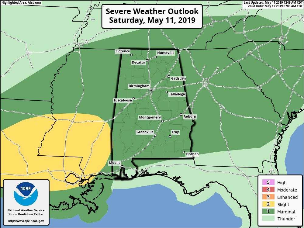
The Storm Prediction Center has nearly the entire state in a Marginal Risk for severe storms for today as a stationary front continues to be stuck over the northwestern parts of the North/Central Alabama. With that front providing the lift, along with building instability during the heating of the day and higher dewpoints, we will see several rounds of storms move through. Now we have low confidence on the placement and timing of the strongest storm due to the pending evolution of each wave of storms, but at this point, it looks like those will be mainly over the western 2/3rds of the area during the mid-afternoon through the late evening hours.
Our main threats for today will be from damaging thunderstorm wind gusts up to 60 MPH and hail up to quarter-size. While a tornado threat is non-zero for today, it is too small to mention and we do not expect any. We still have to stay weather aware and expect the unexpected as we are still in our Spring Severe Weather Season. Highs will be in the mid-70s to the lower 80s. Scattered to numerous showers and storms remain possible throughout the overnight hours with lows dropping into the 60s across the area.
If you’re heading out to the Regions Tradition out at Greystone, there will be a good bit of dry weather, but expect thunderstorms at anytime today, especially during the afternoon hours.
SUNDAY
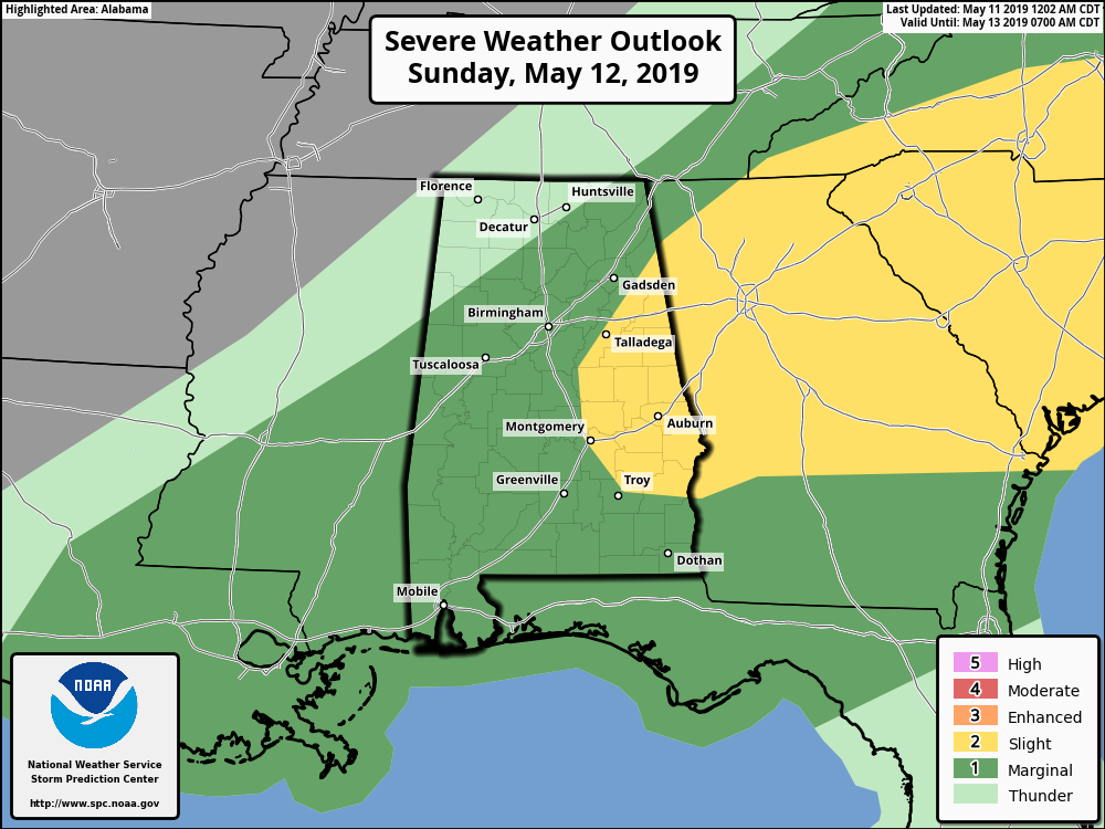
Sunday will be another stormy day with the potential for severe storms across much of Central Alabama. The stationary front starts to move through the area as a cold front giving us a better shot of more organized severe storms. SPC has most of Central Alabama in a Marginal Risk with the exception of much of the eastern and southeastern portions as a Slight Risk is up for those locations.
Once again, damaging winds up to 60 MPH and quarter-size hail will be the main threats, but we will have a small tornado threat as we’ll have a little more shear to deal with. The main window for stronger to severe storms will be from 6:00 am through 2:00 pm as the front moves through the area. We may also have a small threat of some flash flooding issues if training of thunderstorms occur.
Highs on Sunday will be in the mid to upper 70s. Rainfall amounts throughout the weekend will be around 1-2 inches for much of the area, but a few locations could see up to 3 inches. All shower and storm activity will come to an end late on Sunday.
MONDAY
We return to much more beautiful weather on Monday as the front clears the area, leaving us with plenty of sunshine and very nice temperatures. Highs will be in the mid-70s to the lower 80s.
TUESDAY
Much of the same on Tuesday as we continue with plenty of sunshine and highs in the mid-70s to the lower 80s.
WEDNESDAY
We’ll have a deep trough in the northeastern US with strong ridging out to our west. There will be a disturbance that will be moving down the troughing that may swipe the northern parts of Central Alabama during the late afternoon hours and into the first half of Thursday. Much of the day will be mostly sunny but a very small chance of a few showers or thunderstorms will be possible for locations north of the I-20 corridor. Afternoon highs will be in the upper 70s to the lower 80s.
THURSDAY
That disturbance is still with us on Thursday morning but it will finally be out of the area by the late afternoon hours. We’ll continue with a very small chance of a few showers or thunderstorms north of the I-20 corridor. Where there is no rain, skies will be mostly clear. Highs will be in the lower to mid-80s.
FRIDAY
A brilliant and warm Friday will be awaiting us at the end of the work week with nearly maximum sunshine and highs in the lower to mid-80s.
BEACH FORECAST CENTER
Get the latest weather and rip current forecasts for the beaches from Fort Morgan to Panama City on our Beach Forecast Center page. There, you can select the forecast of the region that you are interested in.
PGA CHAMPIONS TOUR RETURNS TO GREYSTONE FOR THE REGIONS TRADITION
The Regions Tradition will be May 8-12 at the beautiful Greystone Golf & Country Club! Make plans to attend one of the majors of the PGA Champions Tour! You can see legendary golfers Miguel Ángel Jiménez, Fred Couples, John Daly, Vijay Singh, and more tee it off with Nick Saban, Gus Malzahn, Bo Jackson, Condoleezza Rice, and other celebrities in the NCR Pro-AM. Juniors 18 & under are admitted free with a ticketed adult, and five-day grounds tickets are $100. Single day grounds tickets are $25. GET YOUR TICKETS HERE!!!
ALREADY OFF TO A HOT START IN 2019! ADVERTISE WITH THE BLOG!
We have enjoyed over 9.1 MILLION page views on AlabamaWx.com so far in 2019! Don’t miss out! We can customize a creative, flexible and affordable package that will suit your organization’s needs. Contact Bill Murray at (205) 687-0782.
E-FORECAST
Get the Alabama Wx Weather Blog’s Seven-Day Forecast delivered directly to your inbox by email twice daily. It is the most detailed weather forecast available in Central Alabama. Subscribe here… It’s free!
CONNECT WITH THE BLOG ON SOCIAL MEDIA
You can find the AlabamaWx Weather Blog on the major social media networks:
Facebook
Twitter
Instagram
WEATHERBRAINS
Don’t forget you can listen to our weekly 90 minute netcast anytime on the web at WeatherBrains.com or on iTunes, Stitcher, or Spotify. This is the show all about weather featuring many familiar voices, including the meteorologists at ABC 33/40.
Category: Alabama's Weather, ALL POSTS, Weather Xtreme Videos
About the Author (Author Profile)
Scott Martin is an operational meteorologist, professional graphic artist, musician, husband, and father. Not only is Scott a member of the National Weather Association, but he is also the Central Alabama Chapter of the NWA president. Scott is also the co-founder of Racecast Weather, which provides forecasts for many racing series across the USA. He also supplies forecasts for the BassMaster Elite Series events including the BassMaster Classic.Subscribe
If you enjoyed this article, subscribe to receive more just like it.


