Believe It Or Not, A Few Returns On Radar At Midday
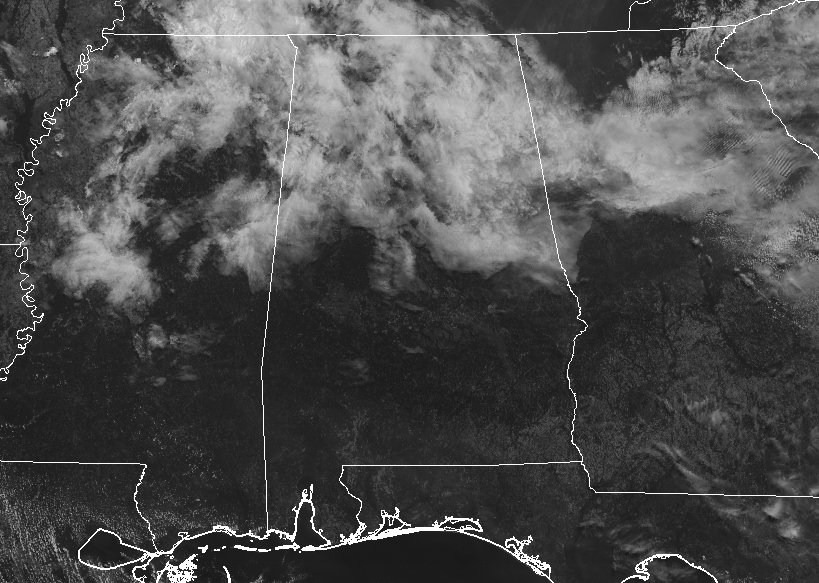
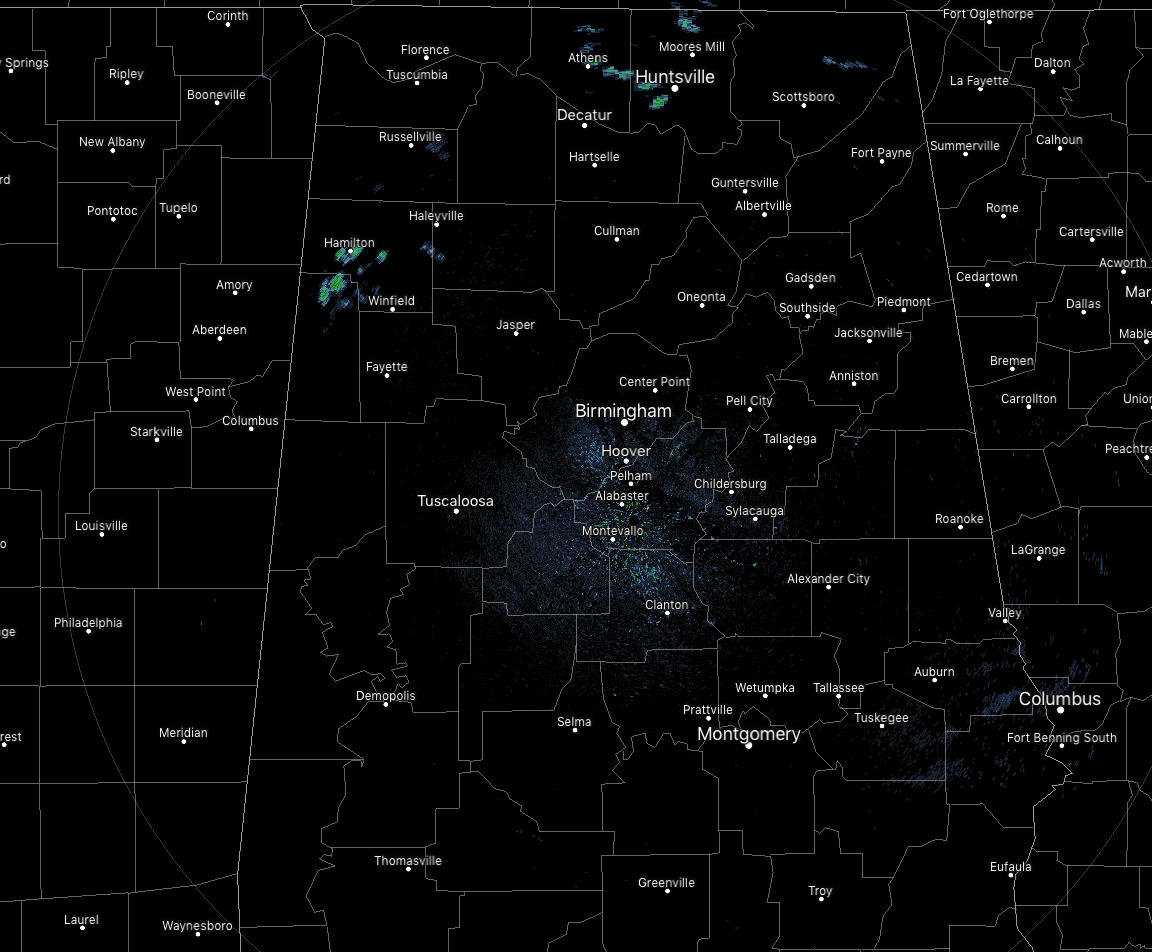
We have some clouds moving over the northern half of Central Alabama as we have hit the 11 o’clock hour. We are actually seeing some returns on the radar over the northern parts of Lamar County and the central parts of Marion County. These may actually be making it to the ground. While they are very small in nature, at least it will cool those temperatures off just a little. Those showers are on the southern end of a cluster of storms that are moving through the northeastern corner of Mississippi and southwestern Tennessee. If these continue on their path to the east, the northern portions of the state north of the Tennessee River may have some rain and storms move through over the next several hours.
There is a wide range of temperatures with the cloud cover and the small showers falling, as we are seeing readings in the mid-70s to the lower 90s. Birmingham was at 82 degrees while the hot spot was Uniontown already at 92 degrees. The cool spot was Haleyville at 75 degrees.
For the rest of the morning and through the afternoon and early evening hours, a few isolated showers or sprinkles may be possible for the extreme northern locations of Central Alabama, while the rest of the area will remain dry. Skies will be mostly clear to partly cloudy across the area with highs reaching the upper 80s to the mid-90s from the north to the south. Clouds will continue to build throughout the evening, leaving us with partly to mostly cloudy skies. Lows will be in the upper 60s to the lower 70s.
On Wednesday, a trough will be approaching from the west and will bring an increase to our scattered shower and thunderstorm chances, most likely during the main heating of the day, but I couldn’t rule out a few during the morning hours. Rain chances will be around 20%-30%, with higher chances in the northern half of the area. Highs will reach the upper 80s to the mid-90s across the area from north to south.
THE TROPICS
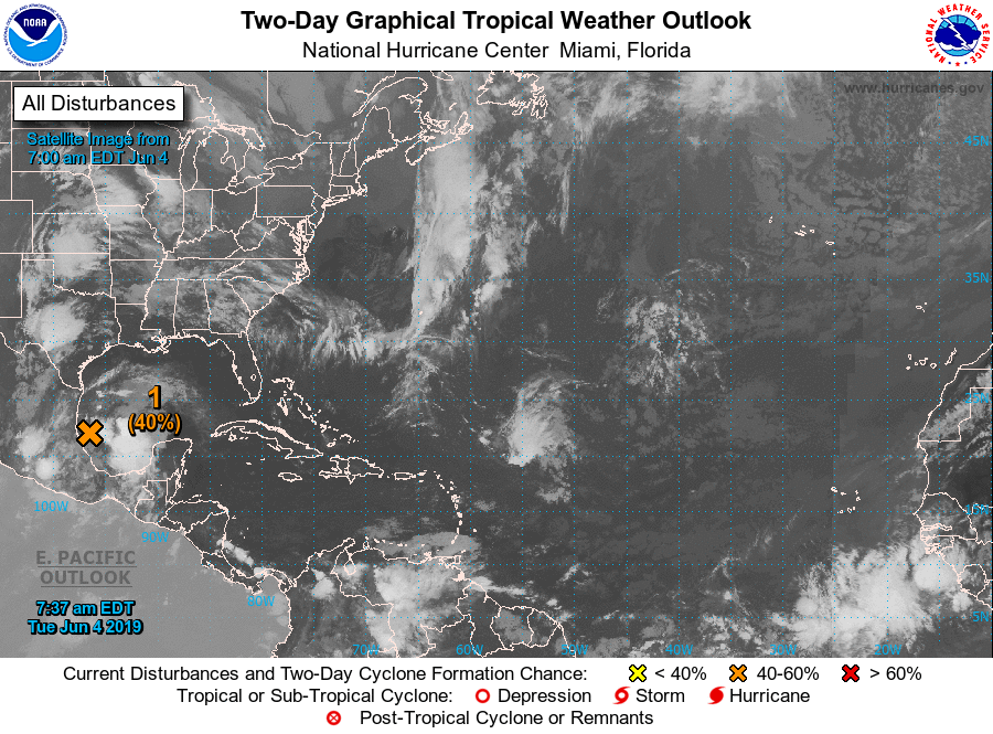
While the disturbance over the southwestern Gulf of Mexico now looks less likely to become a depression, the moisture continues to be shown in the models to be pulled up into the southeastern US. That will bring an enhanced risk of showers and thunderstorms for us throughout the end of the week and into the weekend. At this point, the NHC is only giving it a 40% chance of developing into a depression before moving onshore over Mexico later today or tonight.
ON THIS DAY IN WEATHER HISTORY
1825 – A hurricane struck Long Island NY leveling trees and causing damage to ships. The early season hurricane, which originated around Cuba, caused major damage along the Atlantic coast from Charleston SC to New York City. Many were lost at sea.
BEACH FORECAST CENTER
Get the latest weather and rip current forecasts for the beaches from Fort Morgan to Panama City on our Beach Forecast Center page. There, you can select the forecast of the region that you are interested in.
ALREADY OFF TO A HOT START IN 2019! ADVERTISE WITH THE BLOG!
We have enjoyed over 10 MILLION page views on AlabamaWx.com so far in 2019! Don’t miss out! We can customize a creative, flexible and affordable package that will suit your organization’s needs. Contact Bill Murray at (205) 687-0782.
E-FORECAST
Get the Alabama Wx Weather Blog’s Seven-Day Forecast delivered directly to your inbox by email twice daily. It is the most detailed weather forecast available in Central Alabama. Subscribe here… It’s free!
CONNECT WITH THE BLOG ON SOCIAL MEDIA
You can find the AlabamaWx Weather Blog on the major social media networks:
Facebook
Twitter
Instagram
WEATHERBRAINS
Don’t forget you can listen to our weekly 90 minute netcast anytime on the web at WeatherBrains.com or on iTunes, Stitcher, or Spotify. This is the show all about weather featuring many familiar voices, including the meteorologists at ABC 33/40.
Category: Alabama's Weather, ALL POSTS
About the Author (Author Profile)
Scott Martin is an operational meteorologist, professional graphic artist, musician, husband, and father. Not only is Scott a member of the National Weather Association, but he is also the Central Alabama Chapter of the NWA president. Scott is also the co-founder of Racecast Weather, which provides forecasts for many racing series across the USA. He also supplies forecasts for the BassMaster Elite Series events including the BassMaster Classic.Subscribe
If you enjoyed this article, subscribe to receive more just like it.


