Occasional Rain Through The Weekend For Alabama
DRY SPELL IS OVER: We have measurable rain at Birmingham this morning for the first time since May 16. Radar shows a large mass of rain over most of Alabama, and we will be wet through tomorrow with rain at times along with a few thunderstorms. A few strong storms are possible over parts of Southwest Alabama today; SPC has a “slight risk” (level 2/5) defined for parts of Sumter, Choctaw, and Washington counties… with a “marginal risk” (level 1/5) in the broad zone from Tuscaloosa to Mobile.
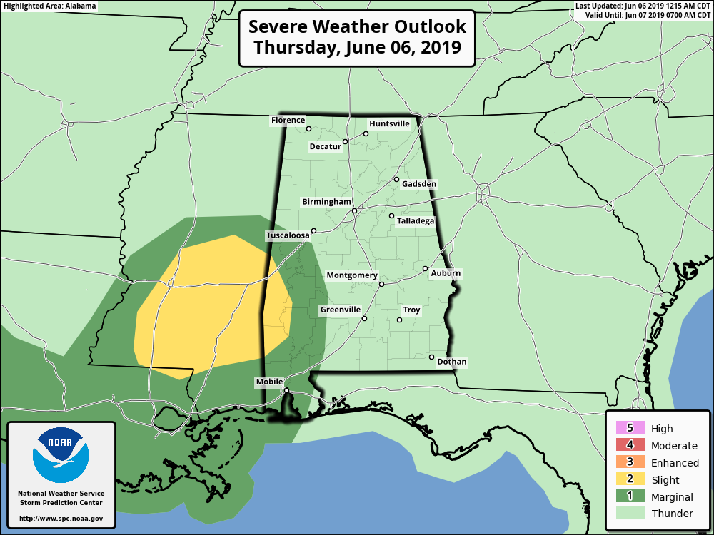
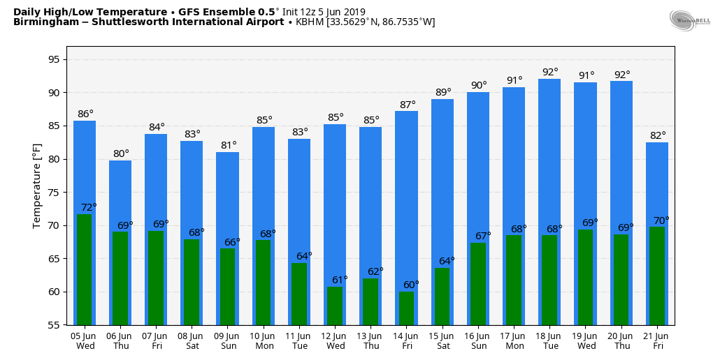
A few storms over the southwest part of the state could produce strong gusty winds later today and early tonight, but severe storms are not expected for most of Alabama. Most communities will stay below 80 degrees today because of clouds and rain, and the high tomorrow will be in the low 80s.
We also note there is a flash flood watch in effect for Mobile and Baldwin counties, and eastward into the Florida Panhandle through tomorrow morning.
THE ALABAMA WEEKEND: No real change. Deep tropical moisture will remain over Alabama with high precipitable water values, and we will see occasional rain and thunderstorms Saturday and Sunday. There will be breaks in the rain, but there is no skill in providing start/stop times for any specific point. We don’t expect any severe thunderstorms, and highs will be mostly in the 79-83 degree range.
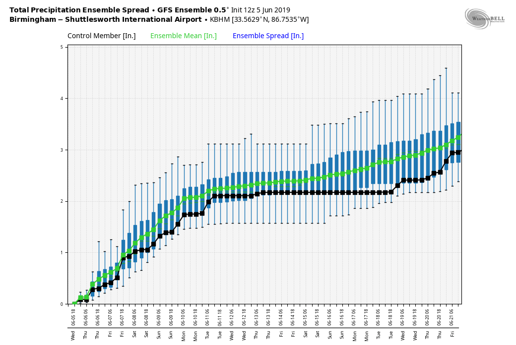
Additional rain amounts of 2-4 inches are likely for most of Alabama from now through Sunday night, with amounts over 5 inches possible for areas near the Gulf Coast. This is a very beneficial rain event for the Deep South.
NEXT WEEK: Wet weather continues on Monday, but drier air begins to move into the state Tuesday as the rain chances diminish, and the rest of the week looks mostly dry. Highs will be generally in the 80s; see the Weather Xtreme video for maps, graphics, and more details.
ON THIS DATE IN 1944: Originally D-Day, the invasion in Normandy, France, was scheduled for June 5, 1944, but the weather was too bad. Instead, the invasion happened the next day, on June 6. Weather conditions would have likely changed the outcome of the largest seaborne invasion in history if the date would have been kept.
Gen. Dwight “Ike” Eisenhower wanted the most accurate forecast, with high confidence and with no room for errors. Capt. James Martin Stagg was the chief meteorologist of the British Royal Air Force and was the one to brief Eisenhower about the rough seas and lashing rain affecting the shore on June 5. Stagg previsioned the small window of better weather for early morning June 6. A high-pressure system was located over Greenland and the Azores, driving a low-pressure system to the north-northeast across the Atlantic. Over these latitudes of the world, it is common to have parades of low-pressure systems, which bring constant periods of unsettled weather and in between, very brief instances of tolerable conditions.
On June 6, a low pressure had moved east of England and a stronger low-pressure was just off the southeast coast of Greenland. Helping even further the invasion was the full moon and an early morning low tide. There were partly cloudy skies allowing the full moon’s light to help soldiers during the overnight invasion and the extreme low tides would ensure extreme low sea level so that the landing crafts and soldiers could spot all mined obstacles scattered on the beaches. Overcast skies dominated inland, where aircraft would drop more than 13,000 bombs. The Germans did not foresee this brief break in the bad weather. In fact, they forecast unsettled weather until mid-June.
BEACH FORECAST: Click here to see the AlabamaWx Beach Forecast Center page.
WEATHER BRAINS: Don’t forget you can listen to our weekly 90 minute show anytime on your favorite podcast app. This is the show all about weather featuring many familiar voices, including our meteorologists here at ABC 33/40.
CONNECT: You can find me on all of the major social networks…
Facebook
Twitter
Instagram
Pinterest
Snapchat: spannwx
Look for the next Weather Xtreme video here by 4:00 this afternoon… enjoy the day!
Category: Alabama's Weather, ALL POSTS, Weather Xtreme Videos
About the Author (Author Profile)
James Spann is one of the most recognized and trusted television meteorologists in the industry. He holds the AMS CCM designation and television seals from the AMS and NWA. He is a past winner of the Broadcast Meteorologist of the Year from both professional organizations.Subscribe
If you enjoyed this article, subscribe to receive more just like it.


