A Marginal Risk For Severe Storms Throughout The Rest Of The Day
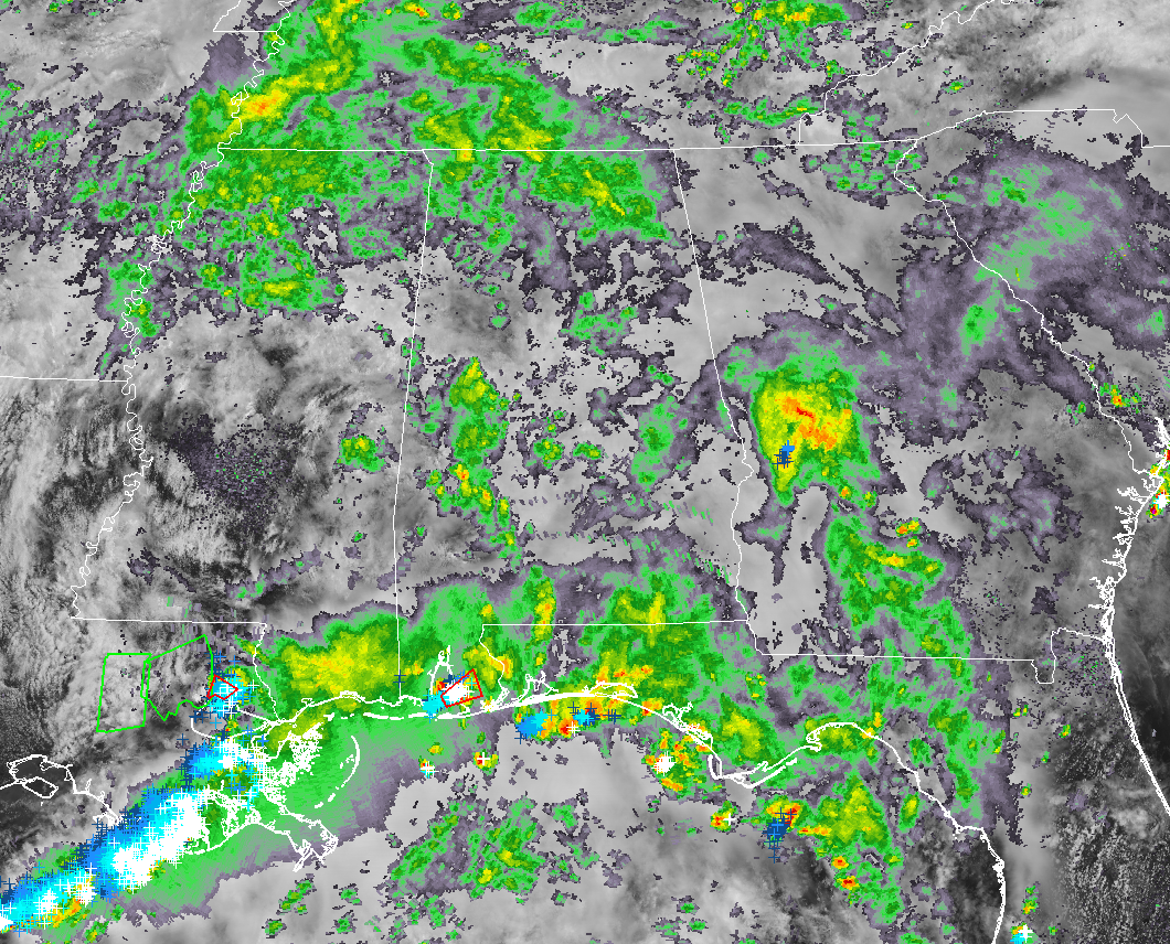
We have an active map across the southeastern United States at this point as we have crossed over into the noon hour on this wet and gray Thursday. We have strong to severe thunderstorms to our south and southwest while we have light to moderate rainfall over parts of Central Alabama. We’ll have to watch for any breaks in the clouds that may occur especially in the south and southwestern parts of the area, where ingredients are a little better for the possibility of strong storms. More on that in a moment.
Temperatures across Central Alabama are in the lower to mid-70s for much of the area with a few upper 70s in the southern parts. Birmingham was at 73 degrees while Tuscaloosa and Troy are tied as the warm spots at 79 degrees.
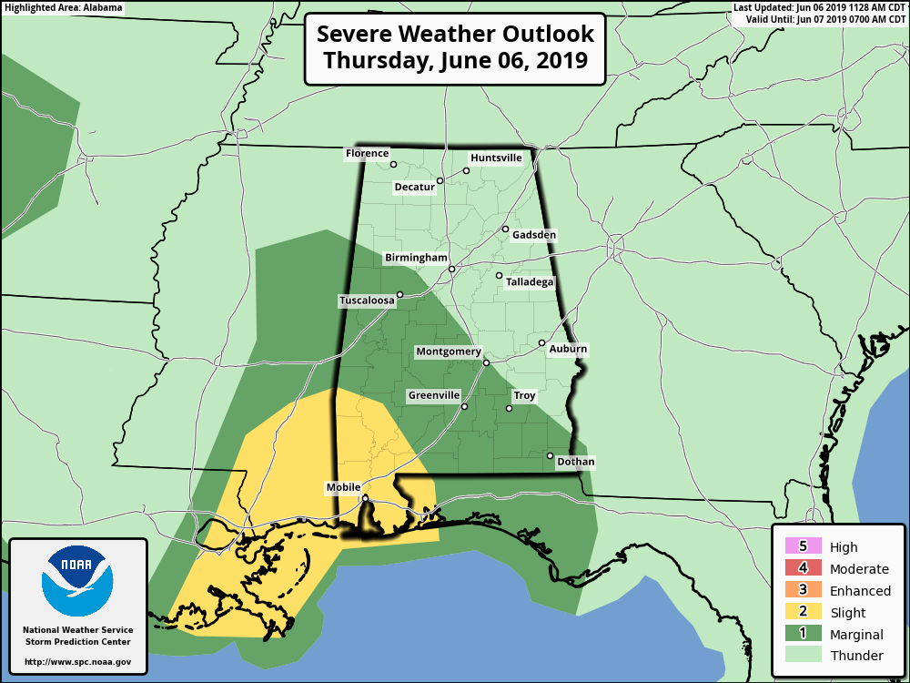
The west and southwestern parts have now been included in a Marginal Risk for severe storms throughout the rest of the day and into the nighttime hours. There is some clearing back to the southwest in the south and southwestern parts of Mississippi that may destabilize the atmosphere enough for strong to severe storms to form during the heating of the day. There is a possibility that these storms would carry over across the state line into the risk area. Damaging winds will be the main threat with the storms today, but an isolated tornado or two cannot be ruled out.
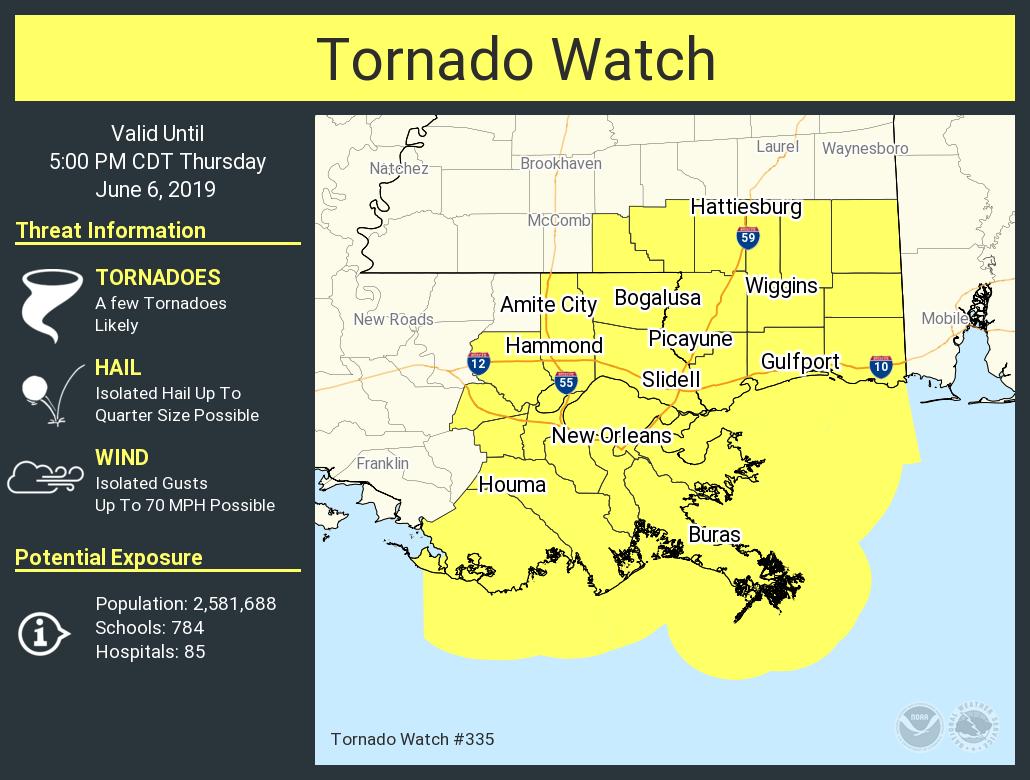
A TORNADO WATCH is already in effect until 5:00 pm this evening for the extreme southeastern parts of Mississippi and for extreme southeastern Louisiana. Just to the east of that, we have already seen a Tornado Warning issued for the southwestern parts of Baldwin County until 12:30 pm for a cell capable of producing a tornado, and is moving to the northeast at 25 MPH. Magnolia Springs, Foley, Robertsdale, Summerdale, and Silverhill are in the path of this storm… so if you know anyone in those communities, please tell them to get to a safe place immediately.
We’ll continue to have scattered to numerous showers and thunderstorms across all of Central Alabama throughout the remainder of the afternoon and into the early evening hours. A few storms in the west and southwestern parts of the area could become strong to severe. Afternoon highs will be in the mid-70s to the lower 80s. For tonight, showers and a few rumbles of thunder will continue to be likely with a few strong storms possible in the southern parts of the area up until midnight. Lows will be in the upper 60s to the lower 70s.
Showers and thunderstorms will continue to be likely at times throughout the day on Friday. Now it may not rain all day long, but rain will be likely at any time. At this point, we do not have a threat of severe weather across Central Alabama, but we’ll keep an eye on the forecast throughout the day from the SPC. Afternoon highs will be in the lower to mid-80s across the area.
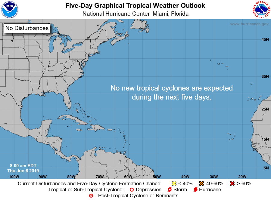
A QUICK LOOK AT THE TROPICS
All is quiet across the Atlantic Basin and no new tropical cyclones are expected to form over the next five days.
BEACH FORECAST CENTER
Get the latest weather and rip current forecasts for the beaches from Fort Morgan to Panama City on our Beach Forecast Center page. There, you can select the forecast of the region that you are interested in.
ALREADY OFF TO A HOT START IN 2019! ADVERTISE WITH THE BLOG!
We have enjoyed over 10 MILLION page views on AlabamaWx.com so far in 2019! Don’t miss out! We can customize a creative, flexible and affordable package that will suit your organization’s needs. Contact Bill Murray at (205) 687-0782.
E-FORECAST
Get the Alabama Wx Weather Blog’s Seven-Day Forecast delivered directly to your inbox by email twice daily. It is the most detailed weather forecast available in Central Alabama. Subscribe here… It’s free!
CONNECT WITH THE BLOG ON SOCIAL MEDIA
You can find the AlabamaWx Weather Blog on the major social media networks:
Facebook
Twitter
Instagram
WEATHERBRAINS
Don’t forget you can listen to our weekly 90 minute netcast anytime on the web at WeatherBrains.com or on iTunes, Stitcher, or Spotify. This is the show all about weather featuring many familiar voices, including the meteorologists at ABC 33/40.
Category: Alabama's Weather, ALL POSTS, Severe Weather
About the Author (Author Profile)
Scott Martin is an operational meteorologist, professional graphic artist, musician, husband, and father. Not only is Scott a member of the National Weather Association, but he is also the Central Alabama Chapter of the NWA president. Scott is also the co-founder of Racecast Weather, which provides forecasts for many racing series across the USA. He also supplies forecasts for the BassMaster Elite Series events including the BassMaster Classic.Subscribe
If you enjoyed this article, subscribe to receive more just like it.


