Strong To Severe Storms Possible Later Today & Tonight
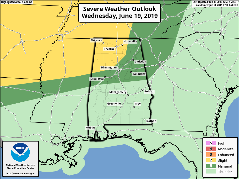
SPC DAY 1 OUTLOOK: A Slight Risk for severe storms up for a good chunk of North/Central Alabama mainly north of a line from Reform to West Jefferson to Blountsville, while a Marginal Risk is up for the rest of the area north of a line from Eutaw to Thorsby to Daviston. This is valid through 7:00 am Thursday.
TODAY: We’ll have a deepening trough over the eastern half of the country with a low that will be developing and strengthening throughout the day today. We’ll have a chance of scattered showers and thunderstorms across the area throughout the daytime hours, with the higher chances stretching roughly from the I-65 corridor to the AL/GA state line. A few of the storms that develop this afternoon may become strong to marginally severe with the potential of isolated damaging wind gusts up to 60 MPH and some small hail. Daytime highs will be in the upper 80s to the lower 90s across the area.
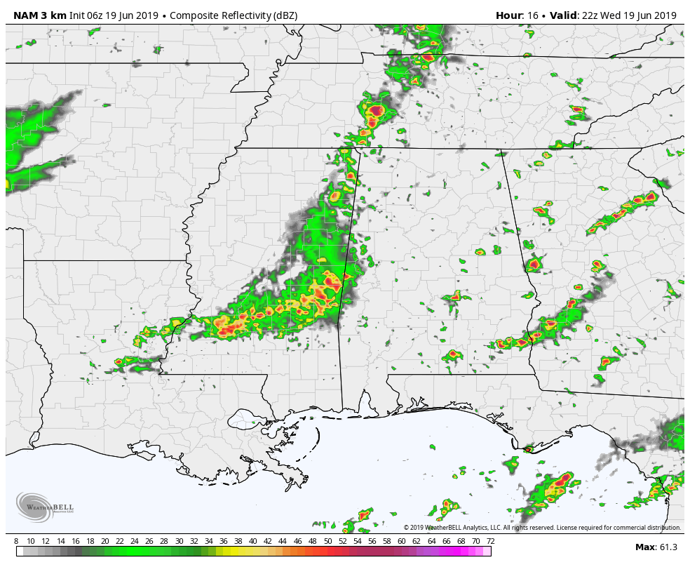
THIS EVENING THROUGH THE OVERNIGHT: We’ll have to watch for storms to move in from the west later today and through the overnight hours as we’ll have an MCS sweeping through Mississippi. The high-resolution NAM has the timing of it entering the state around the evening rush hour and reaching the I-65 corridor by 7:00 pm to 8:00 pm. It will be in the process of weakening as it moves in and will break apart as it moves into the eastern half of the area. This is when we’ll have a larger threat of damaging winds up to 60 MPH, especially in the Slight Risk locations.
After that, there will be another complex of storms moving through the southeast, but it looks to fall apart before really entering into the western parts of the area and is completely gone by sunrise on Thursday. Overnight lows will be in the lower to mid-70s.
THURSDAY: The low really deepens and moves off to our northeast but it will be dragging a shortwave through the area. This will provide enough dynamics that we’ll have the potential for more strong to severe thunderstorms to develop across the area during the afternoon and into the evening and late night hours with damaging wind gusts up to 60 MPH and hail up to golf ball size. Afternoon highs will be in the mid-80s to the lower 90s.
FRIDAY: Ridging will start to build over the southeast and that will be pumping hot and humid air across Central Alabama. We’ll have the general summertime risk of a few scattered afternoon and evening showers and thunderstorms. Highs will be in the lower to mid-90s.
THE CENTRAL ALABAMA WEEKEND: Ridging strengthens throughout the weekend keeping us hot and muggy across Central Alabama. We’ll really have to watch those heat index values as they will be above 100 degrees. We’ll have plenty of sun with only a few clouds, and a very small chance of a few isolated to scattered showers and storms on both days with highs staying in the lower to mid-90s across the area.
START OF NEXT WEEK: The ridge moves more toward the East Coast for the start of next week which will bring an increase to our scattered shower and thunderstorm chances for Monday during the late afternoon and evening hours, and again on Tuesday with skies ranging from mostly clear to partly cloudy. Highs will be in the upper 80s to the lower 90s on both days.
BEACH FORECAST CENTER
Get the latest weather and rip current forecasts for the beaches from Fort Morgan to Panama City on our Beach Forecast Center page. There, you can select the forecast of the region that you are interested in.
ALREADY OFF TO A HOT START IN 2019! ADVERTISE WITH THE BLOG!
We have enjoyed over 10 MILLION page views on AlabamaWx.com so far in 2019! Don’t miss out! We can customize a creative, flexible and affordable package that will suit your organization’s needs. Contact Bill Murray at (205) 687-0782.
E-FORECAST
Get the Alabama Wx Weather Blog’s Seven-Day Forecast delivered directly to your inbox by email twice daily. It is the most detailed weather forecast available in Central Alabama. Subscribe here… It’s free!
CONNECT WITH THE BLOG ON SOCIAL MEDIA
You can find the AlabamaWx Weather Blog on the major social media networks:
Facebook
Twitter
Instagram
WEATHERBRAINS
Don’t forget you can listen to our weekly 90 minute netcast anytime on the web at WeatherBrains.com or on iTunes, Stitcher, or Spotify. This is the show all about weather featuring many familiar voices, including the meteorologists at ABC 33/40.
Category: Alabama's Weather, ALL POSTS, Severe Weather, Weather Xtreme Videos
About the Author (Author Profile)
Scott Martin is an operational meteorologist, professional graphic artist, musician, husband, and father. Not only is Scott a member of the National Weather Association, but he is also the Central Alabama Chapter of the NWA president. Scott is also the co-founder of Racecast Weather, which provides forecasts for many racing series across the USA. He also supplies forecasts for the BassMaster Elite Series events including the BassMaster Classic.Subscribe
If you enjoyed this article, subscribe to receive more just like it.


