Severe Thunderstorm Watch Likely To Our West
A Severe Thunderstorm Watch is likely for northwestern Mississippi, eastern Arkansas, and northeastern Louisiana. Here are the details from the Storm Prediction Center…
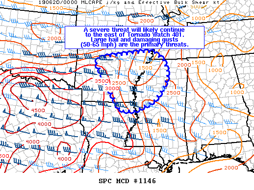
Mesoscale Discussion 1146
NWS Storm Prediction Center Norman OK
08:03 PM CDT Wed Jun 19 2019
Areas affected…central and eastern AR…a small part of western TN…northern and west-central MS…far northeast LA
Concerning…Severe potential…Severe Thunderstorm Watch likely
Valid 200103Z – 200200Z
Probability of Watch Issuance…80 percent
SUMMARY…A severe threat will likely continue east of Tornado Watch 401 into central and eastern portions of AR. The risk for severe storms may eventually move into western and northern parts of MS and adjacent states late this evening into the overnight.
DISCUSSION…Radar mosaic shows a cluster of left-moving supercells over west-central AR with other thunderstorms near Texarkana. A marked difference in buoyancy is evident between the 00z Shreveport, LA raob and the 00z Jackson, MS raob (2600 J/kg vs. 400 J/kg MLCAPE). The gradient in CAPE is largely due to the eastern periphery of the elevated mixed layer and associated lapse rates. Current thinking is a severe threat will probably extend into central and eastern AR but with lower confidence of storm intensity/severe coverage near and east of the MS River. A mix of supercells and the stronger multicells would have an accompanying risk for large hail/damaging gusts.
Category: ALL POSTS, Severe Weather
About the Author (Author Profile)
Scott Martin is an operational meteorologist, professional graphic artist, musician, husband, and father. Not only is Scott a member of the National Weather Association, but he is also the Central Alabama Chapter of the NWA president. Scott is also the co-founder of Racecast Weather, which provides forecasts for many racing series across the USA. He also supplies forecasts for the BassMaster Elite Series events including the BassMaster Classic.Subscribe
If you enjoyed this article, subscribe to receive more just like it.


