Typical Summertime Weather For Today, Tropical Mischief Looking More Likely Later This Week
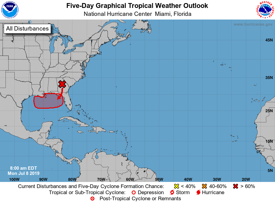
TROPICAL MISCHIEF: The National Hurricane Center increased the risk of a tropical depression forming in the northern Gulf of Mexico to 70% later this week. A low stationed over Georgia will move over the northern Gulf and will help spin up a tropical low in a few days. It is expected to develop and gain some tropical characteristics while meandering around just off the Gulf Coast. It will eventually move northward and then northeast, but timing on that is unclear at this point. Here are some key notes:
• No matter what this disturbance becomes, the main impact will be from heavy rain and rough surf.
• Chances of this developing into a hurricane are very low, but not zero.
• Please understand that the NHC graphic does not show the forecast track of the disturbance, but it shows how the low over Georgia will be drifting over the northern Gulf to help spin up a tropical low.
• Global models continue to be all over the board at this point.
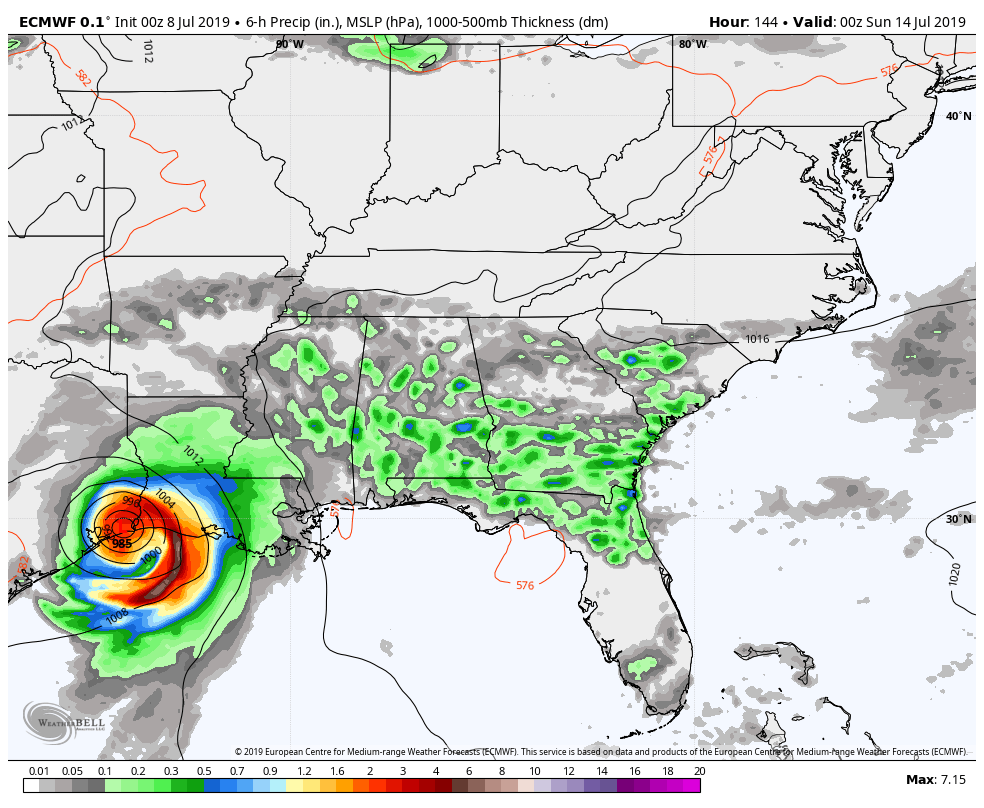
European solution – Saturday 7:00 pm.
• The European model shows the system near Beaumont TX on Saturday night.
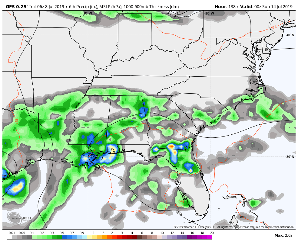
• The GFS shows a broad low/open wave over the Central Gulf Coast at the same time,
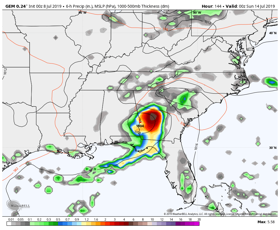
Canadian solution – Saturday 7:00 pm.
while the Canadian shows a more compact system over the AL/GA state line near Phenix City.
• Until the disturbance gets better organized over the northern Gulf, there is simply very little skill in forecasting where the main axis of heavy rain will be located on the Gulf Coast… it’s just too early.
• We have to remember to not focus on the exact location of the lowest pressure with early season disturbances like this… Heavy rain can extend out greatly from the center, especially on the east side where there is an onshore flow.
• The inland parts of the southeast could receive beneficial rainfall from this disturbance, but as I said earlier, its just too early to know where the axis of heavier rain will be located.
• It is too early to provide an exact forecast for a specific point along the Gulf Coast as it is simply impossible to do. We’ll stay on top of it throughout the week.
TODAY: A center of low pressure will start off today stationed over north-central Georgia that will be drifting southward through the day. We’ll have partly to mostly cloudy skies across the area with scattered to numerous showers and storms. The higher concentration of the activity will be located over the southern half of the area. Afternoon highs will be in the lower to mid-90s across the area.
TUESDAY: With the low off to our southeast on Tuesday, ridging will start to build somewhat which will allow for a decrease in the afternoon shower and storm activity. We’ll have mostly clear to partly cloudy skies with a small risk of isolated afternoon showers and storms mainly over the eastern and southeastern locations. Highs will be in the lower to mid-90s for most.
WEDNESDAY: With the uncertainty of the location of the low on Wednesday, it doesn’t look like the weather will change much for Central Alabama. We’ll be hot and humid with partly cloudy skies and a risk of scattered showers and storms. Highs will be in the lower to mid-90s.
THURSDAY: With the GFS model solution, rain chances will increase over Central Alabama on Thursday. We’ll have scattered to numerous showers and storms possible at any time with the higher concentration over the southern half of the area. Skies will be partly to mostly cloudy and highs top out in the lower to mid-90s.
FRIDAY: Much of the same story for Friday as Gulf moisture will continue to be forced up into Central Alabama from the tropical disturbance. Skies will be partly to mostly cloudy with a decent chance of scattered showers and thunderstorms, with the higher concentration over the southern half of the area. Highs will be in the lower 90s.
THE WEEKEND AHEAD: The threat of scattered showers and thunderstorms continue across the area on Saturday and Sunday, but we will not know the true impact of these until we get a better handle on what the tropical disturbance is going to do. For now, we’ll go with a chance of scattered showers and storms throughout each day with the higher concentration of those coming during the main heating of the day. Highs will be in the lower 90s on both days.
BEACH FORECAST CENTER: Get the latest weather and rip current forecasts for the beaches from Fort Morgan to Panama City on our Beach Forecast Center page. There, you can select the forecast of the region that you are interested in.
ALREADY OFF TO A HOT START IN 2019! ADVERTISE WITH THE BLOG!: We have enjoyed over 10 MILLION page views on AlabamaWx.com so far in 2019! Don’t miss out! We can customize a creative, flexible and affordable package that will suit your organization’s needs. Contact Bill Murray at (205) 687-0782.
E-FORECAST: Get the Alabama Wx Weather Blog’s Seven-Day Forecast delivered directly to your inbox by email twice daily. It is the most detailed weather forecast available in Central Alabama. Subscribe here… It’s free!
CONNECT WITH THE BLOG ON SOCIAL MEDIA: You can find the AlabamaWx Weather Blog on the major social media networks:
Facebook
Twitter
Instagram
WEATHERBRAINS: Don’t forget you can listen to our weekly 90 minute netcast anytime on the web at WeatherBrains.com or on iTunes, Stitcher, or Spotify. This is the show all about weather featuring many familiar voices, including the meteorologists at ABC 33/40.
Category: Alabama's Weather, ALL POSTS, Tropical, Weather Xtreme Videos
About the Author (Author Profile)
Scott Martin is an operational meteorologist, professional graphic artist, musician, husband, and father. Not only is Scott a member of the National Weather Association, but he is also the Central Alabama Chapter of the NWA president. Scott is also the co-founder of Racecast Weather, which provides forecasts for many racing series across the USA. He also supplies forecasts for the BassMaster Elite Series events including the BassMaster Classic.Subscribe
If you enjoyed this article, subscribe to receive more just like it.


