A Few Showers Forming At Midday, Tropical Development Likely This Week
WHAT’S GOING ON AT 11:50 AM
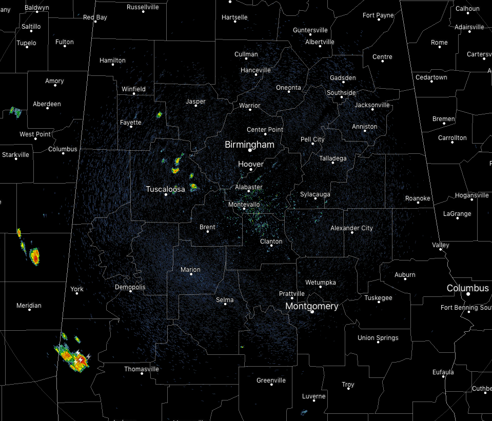
While most of Central Alabama is quiet at this point on this second Monday of July, we are already starting to see the formation of showers over the western parts of the area, especially over portions of Fayette and Tuscaloosa counties.
The rest of Central Alabama has mostly sunny to partly cloudy skies and is free from rainfall. Temperatures are in the mid-80s to the lower 90s across the area. Birmingham was at 88 degrees while the “hot” spot was Tuscaloosa at 91 degrees. The cool spot was Sylacauga at 85 degrees.
WEATHER FOR THE REST OF YOUR MONDAY
We’ll continue to have partly cloudy skies across the area with more scattered showers and thunderstorm form with the main heating of the day, especially south of a line from Fayette to Birmingham to Anniston. North of that, a few isolated showers and thunderstorms are possible. Afternoon highs will be in the lower to mid-90s. A few isolated to scattered showers and storms will remain possible in the southern half of the area throughout the late night and overnight hours while much of the northern half will be dry. Lows will be in the lower to mid-70s.
A LITTLE DRIER ON TUESDAY
It still looks like ridging will build in for a little while over the western parts of the southeast US while the low will start to get its act together over the northern Gulf of Mexico just off of the Florida Panhandle. Much of the western parts of Central Alabama will be dry throughout the day while locations east of a line from Selma to Clanton to Gadsden could see a few isolated to scattered afternoon showers and thunderstorms. We’ll stay hot and humid with a good bit of sun early with some clouds building during the heating of the day. Highs will be in the lower to mid-90s for much of Central Alabama while a few in the southern parts will reach the upper 90s.
TROPICAL UPDATE
The area of interest currently given the name of Invest 92L by the National Hurricane Center is located just north of Macon Georgia at this time and is drifting to the south heading toward the northern Gulf of Mexico. This system is already showing a strong amount of counterclockwise spin. It should cross over the coastline around Panama City Beach and move out over the northern Gulf later this evening.
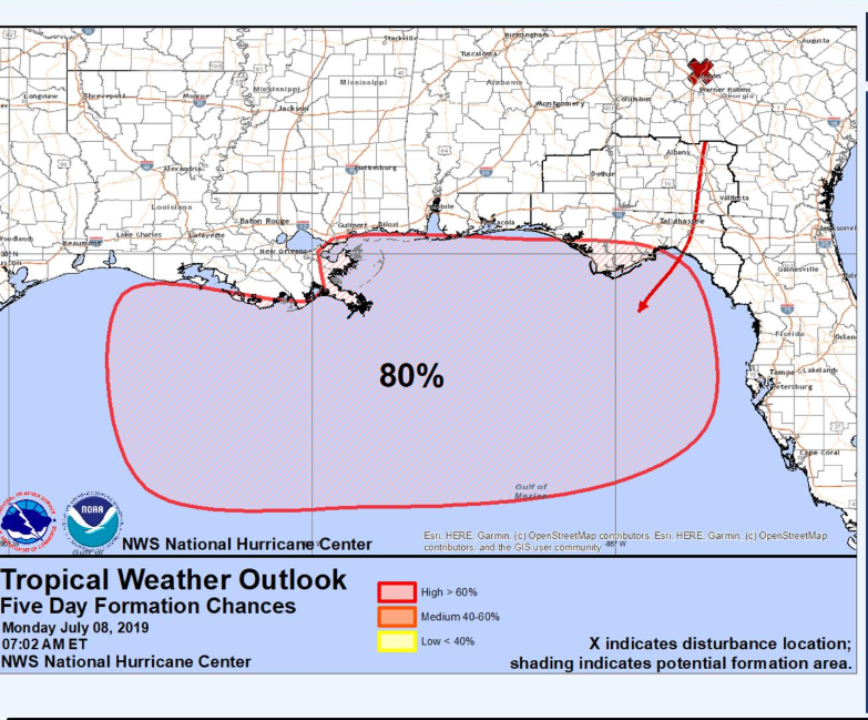
With water temperatures averaging between 85-88 degrees along and just off of the Gulf Coast and a lack of wind shear in place, the low will gain tropical characteristics quickly as it moves over the warm waters of the Gulf. I wouldn’t be surprised if we have a depression or Tropical Storm Barry by Wednesday evening.
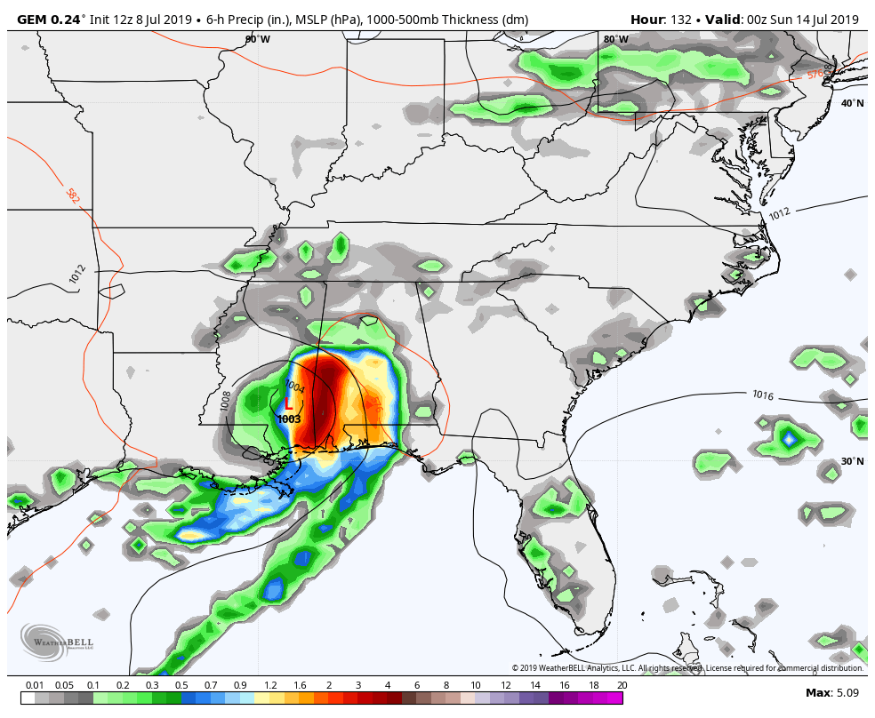
While most models take it toward the coastline of Texas and Louisiana, the Canadian curves it back around and back up through the southern parts of Alabama as soon as Saturday evening. At this point, it is still too early to make a forecast on its path until it gets better organized within a day or two.
TODAY IN WEATHER HISTORY
1975 – Three people were killed and six others were injured when lightning struck a walnut tree near Mayo, FL. The nine people were stringing tobacco under a tin shed when the bolt hit the nearby tree.
BEACH FORECAST CENTER
Get the latest weather and rip current forecasts for the beaches from Fort Morgan to Panama City on our Beach Forecast Center page. There, you can select the forecast of the region that you are interested in.
ALREADY OFF TO A HOT START IN 2019! ADVERTISE WITH THE BLOG!
We have enjoyed over 10 MILLION page views on AlabamaWx.com so far in 2019! Don’t miss out! We can customize a creative, flexible and affordable package that will suit your organization’s needs. Contact Bill Murray at (205) 687-0782.
E-FORECAST
Get the Alabama Wx Weather Blog’s Seven-Day Forecast delivered directly to your inbox by email twice daily. It is the most detailed weather forecast available in Central Alabama. Subscribe here… It’s free!
CONNECT WITH THE BLOG ON SOCIAL MEDIA
You can find the AlabamaWx Weather Blog on the major social media networks:
Facebook
Twitter
Instagram
WEATHERBRAINS
Don’t forget you can listen to our weekly 90 minute netcast anytime on the web at WeatherBrains.com or on iTunes, Stitcher, or Spotify. This is the show all about weather featuring many familiar voices, including the meteorologists at ABC 33/40.
Category: Alabama's Weather, ALL POSTS, Tropical
About the Author (Author Profile)
Scott Martin is an operational meteorologist, professional graphic artist, musician, husband, and father. Not only is Scott a member of the National Weather Association, but he is also the Central Alabama Chapter of the NWA president. Scott is also the co-founder of Racecast Weather, which provides forecasts for many racing series across the USA. He also supplies forecasts for the BassMaster Elite Series events including the BassMaster Classic.Subscribe
If you enjoyed this article, subscribe to receive more just like it.


