Hot/Steamy Today; Eyes Remain On The Gulf
HOT, MUGGY JULY DAY: A heat advisory is in effect for much of Central and Northwest Alabama today, where highs will be in the mid 90s and humidity levels will be pretty oppressive. But, all 67 counties will be hot and humid with high in the 90s. A few showers and storms will form during the heat of the day, but they should be fairly widely scattered.
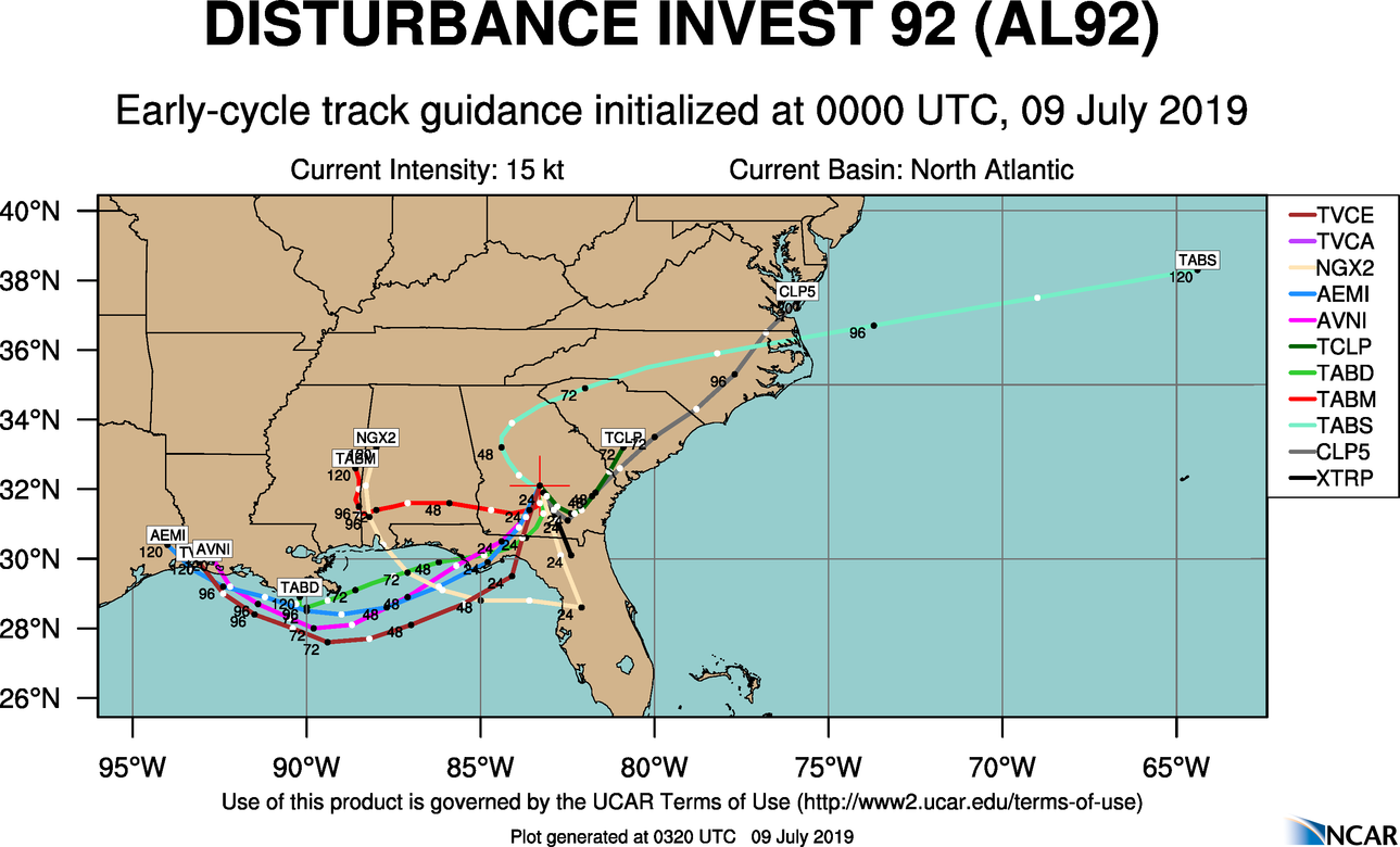
REST OF THE WEEK: The weather will be determined by a developing tropical system in the northern Gulf of Mexico, and a surface front drifting down our way from the north. Here is the latest on the tropical system (now Invest 92L)…
*A tropical depression or tropical storm is expected to form south of the Central Gulf Coast by Thursday. If it becomes a tropical storm, the name will be “Barry”.
*The system is not expected to reach hurricane strength. The main impact for coast will come from heavy rain and rough surf/rip currents. An isolated waterspout or tornado is also possible by Thursday; SPC has a “marginal risk” (level 1/5) of severe storms defined on the coasts of Mississippi, Alabama, and the western Florida Panhandle.
*Once it forms, the tropical system will drift westward; most models have it somewhere around the Sabine Pass (the Texas/Louisiana border) by Saturday. But, don’t focus too much on the center of circulation; the rain shield will extend out a few hundred miles to the east, most likely. The east side will be the wet, onshore flow side.
*For now, WPC (NOAA’s Weather Prediction Center) has the heaviest rain from the Mississippi coast west to Southeast Texas… lighter amounts are forecast from Dauphin Island over to Panama City Beach.
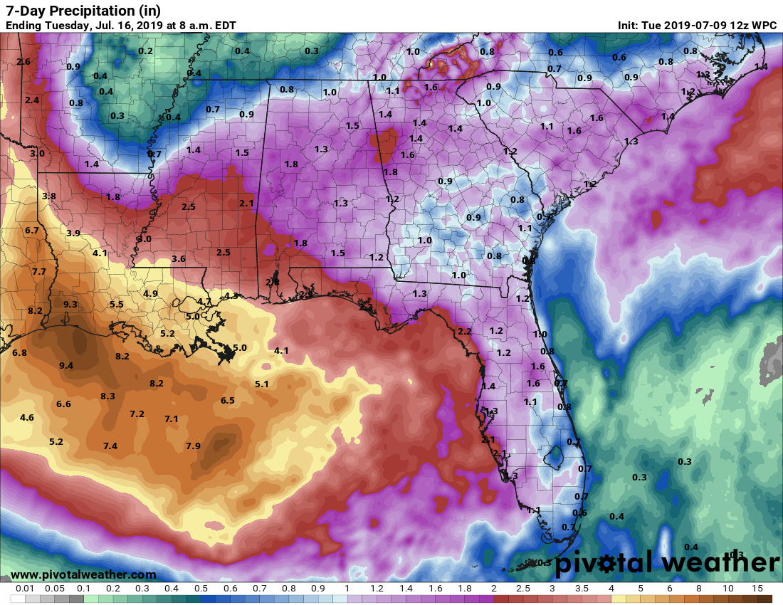
But understand drawing this map right now is a big challenge; until the system actually develops over the Gulf, confidence is low in forecasting the axis of the heaviest rain. This forecast can, and probably will change in coming days.
*I would suggest for the Alabama and Northwest Florida coasts the most widespread rain will come Thursday and Friday, but even then it won’t rain all day. Showers and storms remain possible over the weekend, but they become more scattered in nature as the tropical feature drifts westward.
*For inland parts of Alabama, the combination of deeper moisture from the tropical feature, and a surface front stalling out near the Tennessee border will bring numerous showers and thunderstorms Thursday and Friday. Showers and storms remain possible over the weekend, but they will slowly thin out. Highs drop into the upper 80s by Friday and Saturday because of increased cloud cover and the shower/thunderstorm activity.
*For those asking if they should cancel a beach trip, I can’t answer that. Different people go to the beach for different reasons. I would not hesitate to go, but I am not the one looking for a bright sunny day. Just understand you will have occasional showers and thunderstorms later this week, with the highest impact Thursday and Friday. Dangerous surf and rip tides are likely on these days, and a brief waterspout or tornado is possible in spots. But, it won’t rain all day Thursday and Friday. Then, showers and storms slowly decrease in number over the weekend.
NEXT WEEK: The week looks like we will have fairly routine weather across the Deep South with the usual daily threat of “scattered, mostly afternoon and evening showers and thunderstorms”. Highs will be in the 88-93 degree range. See the Weather Xtreme video for maps, graphics, and more details.
ON THIS DATE IN 1979: Hurricane Bob was born in the Gulf of Mexico, becoming the first Atlantic Hurricane to be given a male name.
BEACH FORECAST: Click here to see the AlabamaWx Beach Forecast Center page.
WEATHER BRAINS: Don’t forget you can listen to our weekly 90 minute show anytime on your favorite podcast app. This is the show all about weather featuring many familiar voices, including our meteorologists here at ABC 33/40.
CONNECT: You can find me on all of the major social networks…
Facebook
Twitter
Instagram
Pinterest
Snapchat: spannwx
Look for the next Weather Xtreme video here by 4:00 this afternoon… enjoy the day!
Category: Alabama's Weather, ALL POSTS, Weather Xtreme Videos
About the Author (Author Profile)
James Spann is one of the most recognized and trusted television meteorologists in the industry. He holds the AMS CCM designation and television seals from the AMS and NWA. He is a past winner of the Broadcast Meteorologist of the Year from both professional organizations.Subscribe
If you enjoyed this article, subscribe to receive more just like it.


