A Touch Of Fall In The Air
REFRESHING CHANGE: The long awaited surface front is pushing through South Alabama this afternoon… drier air continues to flow into the northern part of the state with a partly sunny sky, lower humidity levels, and below average temperatures. Birmingham reports only 78 degrees at 2:00p CT… the record low maximum fo July 23 is 78, set in 1938. We will probably creep up toward 80 before the day is over, but this is still over 10 degrees below average.
Showers and strong storms are over far South Alabama, in advance of the front. Those will move offshore this evening.
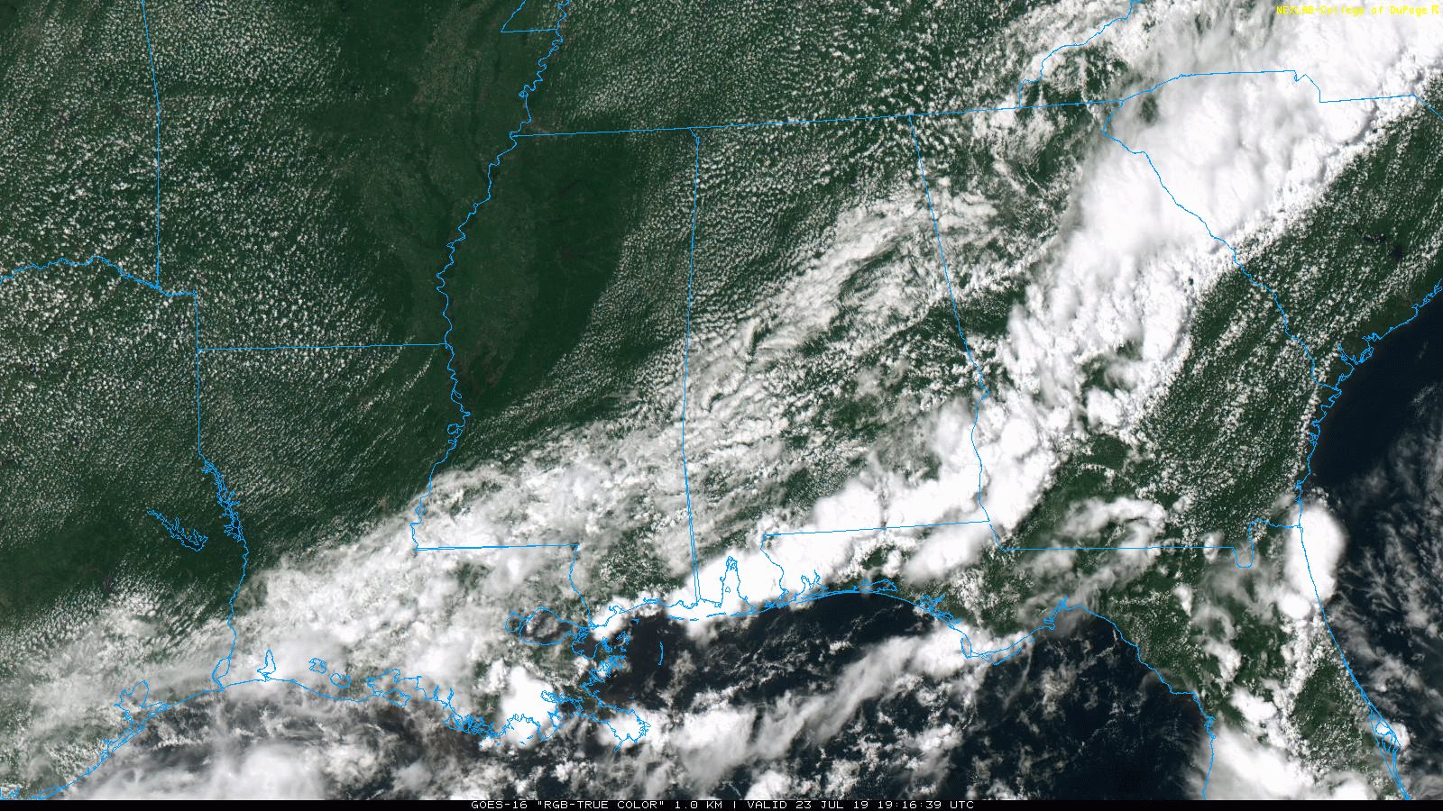
Tonight will be fair and cooler, temperatures will drop into the 60-65 degree range over the northern half of the state, with upper 50s likely for cooler valleys.
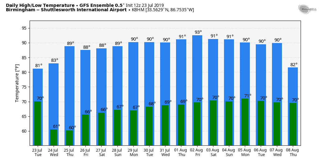
TOMORROW THOUGH FRIDAY: Not much change. Mostly sunny days, low humidity levels for summer, and fair, pleasant nights. Showers and storms will be confined to coastal areas, and even there they will be pretty widely scattered. Highs will be in the mid 80s tomorrow, followed by upper 80s Thursday and Friday.
THE ALABAMA WEEKEND: Moisture levels will rise, humidity values come up, and we will bring back the risk of “scattered, mostly afternoon and evening showers and thunderstorms”. Otherwise, expect partly sunny days with high between 87 and 90 degrees.
NEXT WEEK: For now we will go with a standard summer forecast through the weekend. Partly sunny, hot, and humid each day with the risk of a passing afternoon shower or storm in spots. Highs mostly in the low 90s… right at seasonal averages for late July. See the Weather Xtreme video for maps, graphics, and more details.
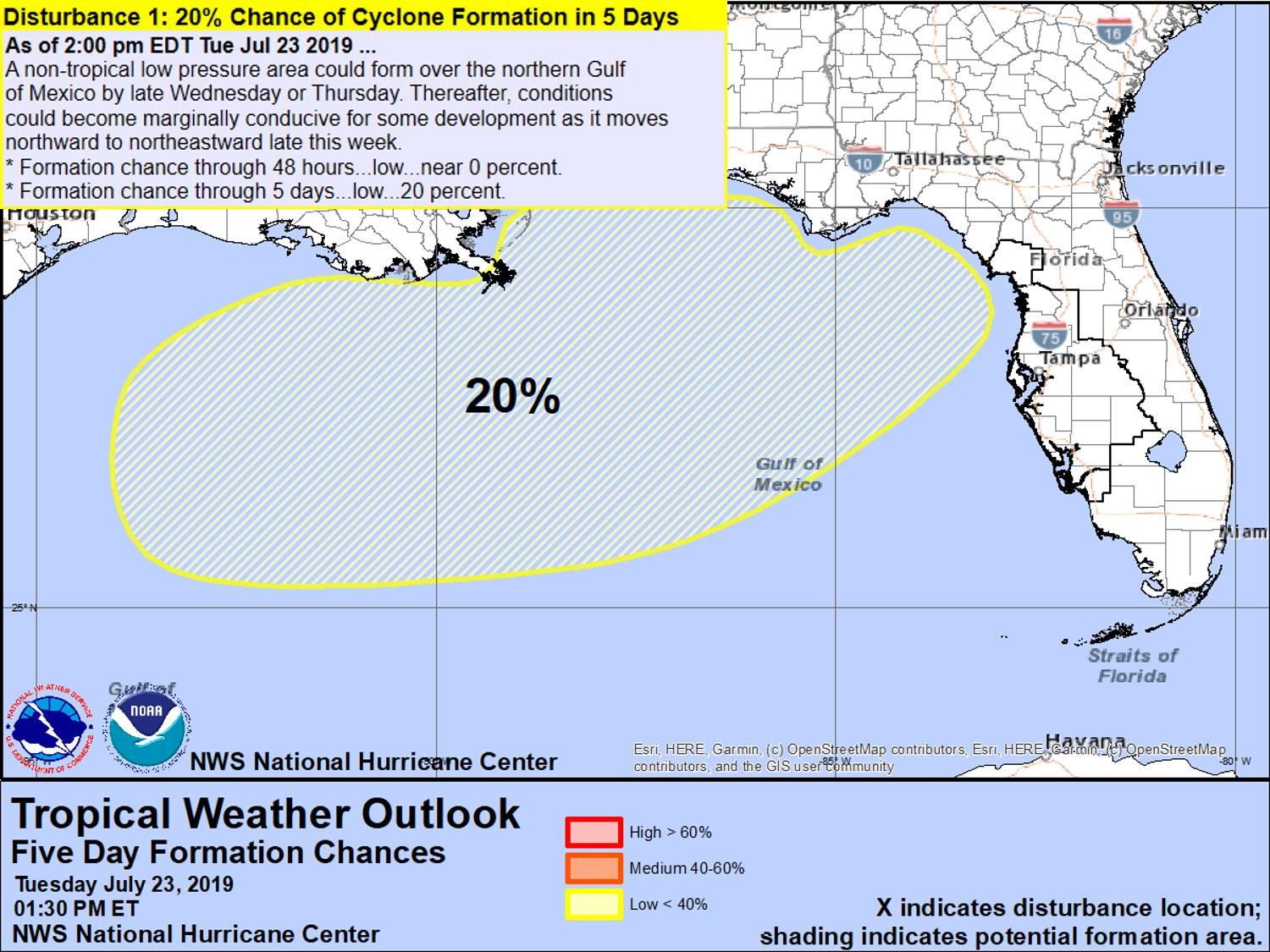
TROPICS: Tropical Depression Three dissipated this morning off the Florida East Coast. NHC is now giving a 20 percent of tropical depression or storm formation across the northern Gulf of Mexico late this week and over the weekend, in the vicinity of the stalled front.
ON THIS DATE IN 1788: Called the George Washington’s Hurricane, this storm originated near Bermuda on the 19th before making landfall in Virginia. It passed directly over the Lower Chesapeake Bay and Mount Vernon, the home of George Washington. This track is very similar to the path of the Chesapeake-Potomac hurricane of 1933. At Norfolk, winds increased at 5 p.m. on the 23rd with the wind originating from the northeast. At 12:30 a.m., the wind suddenly shifted to the south and “blew a perfect hurricane, tearing down chimneys, fences”…some corn was also leveled. Also, large trees were uprooted, and houses were moved from their foundations.
BEACH FORECAST: Click here to see the AlabamaWx Beach Forecast Center page.
WEATHER BRAINS: Don’t forget you can listen to our weekly 90 minute show anytime on your favorite podcast app. This is the show all about weather featuring many familiar voices, including our meteorologists here at ABC 33/40.
CONNECT: You can find me on all of the major social networks…
Facebook
Twitter
Instagram
Pinterest
Snapchat: spannwx
I enjoyed seeing the kids in the Oxford Day Camp this morning… be looking for them on the Pepsi KIDCAM today at 5:00 on ABC 33/40 News! The next Weather Xtreme video will be posted here by 7:00 a.m. tomorrow…
Category: Alabama's Weather, ALL POSTS, Weather Xtreme Videos
About the Author (Author Profile)
James Spann is one of the most recognized and trusted television meteorologists in the industry. He holds the AMS CCM designation and television seals from the AMS and NWA. He is a past winner of the Broadcast Meteorologist of the Year from both professional organizations.Subscribe
If you enjoyed this article, subscribe to receive more just like it.


