

Saturday Afternoon Update
Not much change in the day to day weather through the holiday. Today, much of North/Central Alabama will be dry with a mix of sun and clouds and highs in the lower 90s. Will there be rain in the state today, sure, but any shower/storm activity today will be confined to southern portions of the state, and even there we are not expecting much on the radar.
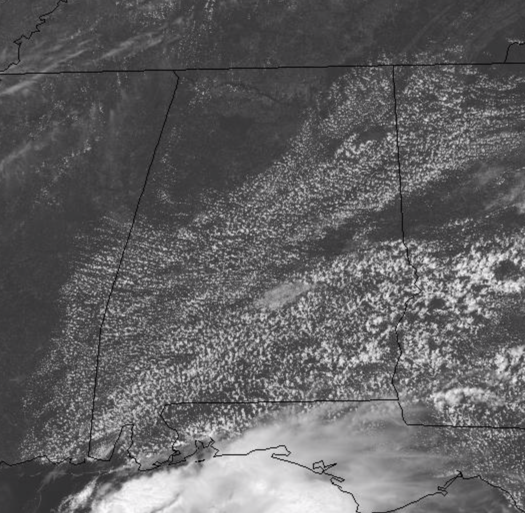
For tomorrow, we should see a few showers and storms across North/Central Alabama but still these will remain few and far between. Then for Labor Day, expect a generally dry and mainly sunny day with highs again in the lower 90s.
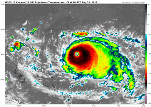
HURRICANE DORIAN: At 200 PM EDT, the distinct eye of Hurricane Dorian was located near latitude 26.1 North, longitude 73.9 West. Dorian is moving toward the west near 8 mph, and a slower westward motion should continue into early next week. On this track, the core of Dorian should move over the Atlantic well north of the southeastern and central Bahamas today, be near or over the northwestern Bahamas on Sunday, and move near the Florida east coast late Monday through Tuesday.
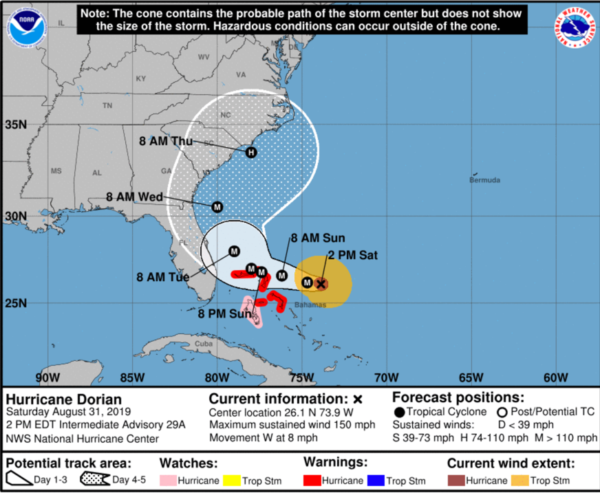
Data from an Air Force reconnaissance plane indicate that the maximum sustained winds are near 150 mph with higher gusts. Dorian is a category 4 hurricane on the Saffir-Simpson Hurricane Wind Scale. Some fluctuations in intensity are likely, but Dorian is expected to remain a powerful hurricane during the next few days. The minimum central pressure reported by a reconnaissance plane was 945 mb (27.91 inches).
Key Messages:
1. A prolonged period of life-threatening storm surge and devastating hurricane-force winds are expected in portions of the northwestern Bahamas, particularly on the Abaco Islands and Grand Bahama Island. A hurricane warning is in effect for these areas, and residents should listen to advice given by local emergency officials and have their hurricane preparations completed today.
2. Life-threatening storm surge and dangerous hurricane-force winds are still possible along portions of the Florida east coast by the early to middle part of next week, but since Dorian is forecast to slow down and turn northward near or just offshore of the coast, it is too soon to determine when or where the highest surge and winds could occur. Residents should have their hurricane plan in place, know if they are in a hurricane evacuation zone, and listen to advice given by local emergency officials.
3. The risk of strong winds and dangerous storm surge is increasing along the coasts of Georgia, South Carolina, and North Carolina during the middle of next week. Residents in these areas should continue to monitor the progress of Dorian.
4. Heavy rains, capable of life-threatening flash floods, are expected over portions of the Bahamas and coastal sections of the southeastern United States this weekend through much of next week.
ELSEWHERE IN THE TROPICS: As expected, as we head through the end of August and into September, the tropics will get very active as we are in the heart of the season. There are two other areas of interest the NHC is monitoring:
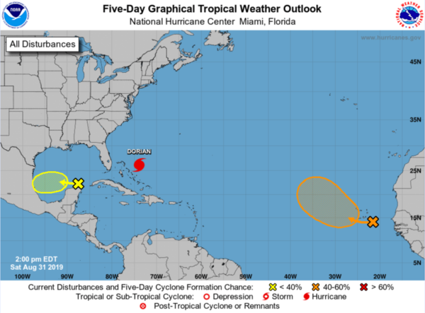
1. A tropical wave located a little more than 100 miles east of the Cabo Verde Islands is producing widespread cloudiness and showers. Environmental conditions are forecast to be conducive for development of this disturbance during the next few days and a tropical depression could form next week while the system moves across the eastern tropical Atlantic Ocean. Heavy rainfall is possible over portions of the southern Cabo Verde Islands during the next couple of days, and interests on those islands should monitor the progress of this system. Formation chance through 48 hours…low…20 percent. Formation chance through 5 days…medium…60 percent.
2. A broad area of low pressure located over the southeastern Gulf of Mexico is producing limited shower and thunderstorm activity. Some gradual development of this system is possible during the next few days while it moves slowly westward across the southern and southwestern Gulf of Mexico. Formation chance through 48 hours…low…20 percent. Formation chance through 5 days…low…30 percent.
The next names up on the list at Fernand and Gabrielle.
GEOMAGNETIC STORM IN PROGRESS: A solar wind stream blowing faster than 700 km/s is lashing Earth’s magnetic field on Aug. 31st. This has sparked a G2-class (moderately strong) geomagnetic storm. So far auroras have been observed in Iceland, Alaska, Finland, Wisconsin and Michigan–with more expected tonight if the storm continues.
THE WEEK AHEAD: With Dorian staying well to the east of the state, we expect no impacts on Alabama. If anything, with the subsidence around the system and northerly wind flow on this side of the system, our weather should be generally dry and mainly sunny with highs in the lower 90s and lows in the upper 60s to lower 70s. Nothing too unusual for the first week of September. Also note, typically during September, we will start to dry out as September and October are typically our driest months of the year in Alabama.
BEACH FORECAST CENTER: Get the latest weather and rip current forecasts for the beaches from Fort Morgan to Panama City on our Beach Forecast Center page. There, you can select the forecast of the region that you are interested in visiting.
WORLD TEMPERATURE EXTREMES: Over the last 24 hours, the highest observation outside the U.S. was 122.5F at Failakah Island, Kuwait. The lowest observation was -96.9F at Dome A, Antarctica.
CONTIGUOUS TEMPERATURE EXTREMES: The highest observation was 116F at Death Valley and Thermal, CA. The lowest observation was 28F at Cowdrey, CO and Albany, WY.
WEATHER ON THIS DATE IN 1954: Hurricane Carol swept across eastern New England killing sixty persons and causing 450 million dollars damage. It was the first of three hurricanes to affect New England that year.
Category: Alabama's Weather, ALL POSTS
About the Author (Author Profile)
Macon, Georgia Television Chief Meteorologist, Birmingham native, and long time Contributor on AlabamaWX. Stormchaser. I did not choose Weather, it chose Me. College Football Fanatic. @Ryan_StinnetSubscribe
If you enjoyed this article, subscribe to receive more just like it.


