Hot, Dry Weekend Ahead
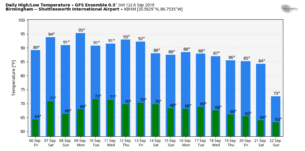
PLEASANT FRIDAY: Temperatures are very close to seasonal average for early September; most places are in the 88-92 degree range this afternoon with a sunny sky and low humidity. Tonight will be fair, but not as cool as last night as dew points begin to rise.
HOT WEEKEND: Look for highs in the mid 90s tomorrow and Sunday with a good supply of sunshine both days. Humidity levels will be a bit higher, and I can’t totally rule out a few isolated showers or storms during the afternoon and evening hours. But, odds of any one spot getting wet are under 10 percent across North/Central Alabama, so we won’t mention it in the formal forecast.
NEXT WEEK: The overall situation won’t change much. We could see a few widely scattered showers on a day or two, but much of the week will be dry with partly to mostly sunny days and highs in the low 90s. See the Weather Xtreme video for maps, graphics, and more details.
FOOTBALL WEATHER: For the high school games tonight, the sky will be clear with temperatures falling from the mid 80s at kickoff, into the upper 70s by the final whistle.
Tomorrow, Alabama hosts New Mexico State at Bryant-Denny Stadium in Tuscaloosa (3p CT kickoff)… it will be a sizzling afternoon with a kickoff temperature near 97 degrees, falling into the low 90s by the fourth quarter. The sky will be mostly sunny.
Auburn will host Tulane tomorrow evening (6:30p CT kickoff)… the sky will be clear with temperatures falling from 90 degrees at kickoff into the upper 70s by the final whistle.
UAB is on the road… they travel to Akron, Ohio to play the Zips tomorrow (11a CT kickoff). The sky will be mostly sunny with temperatures rising from near 70 at kickoff, into the mid 70s by the fourth quarter.
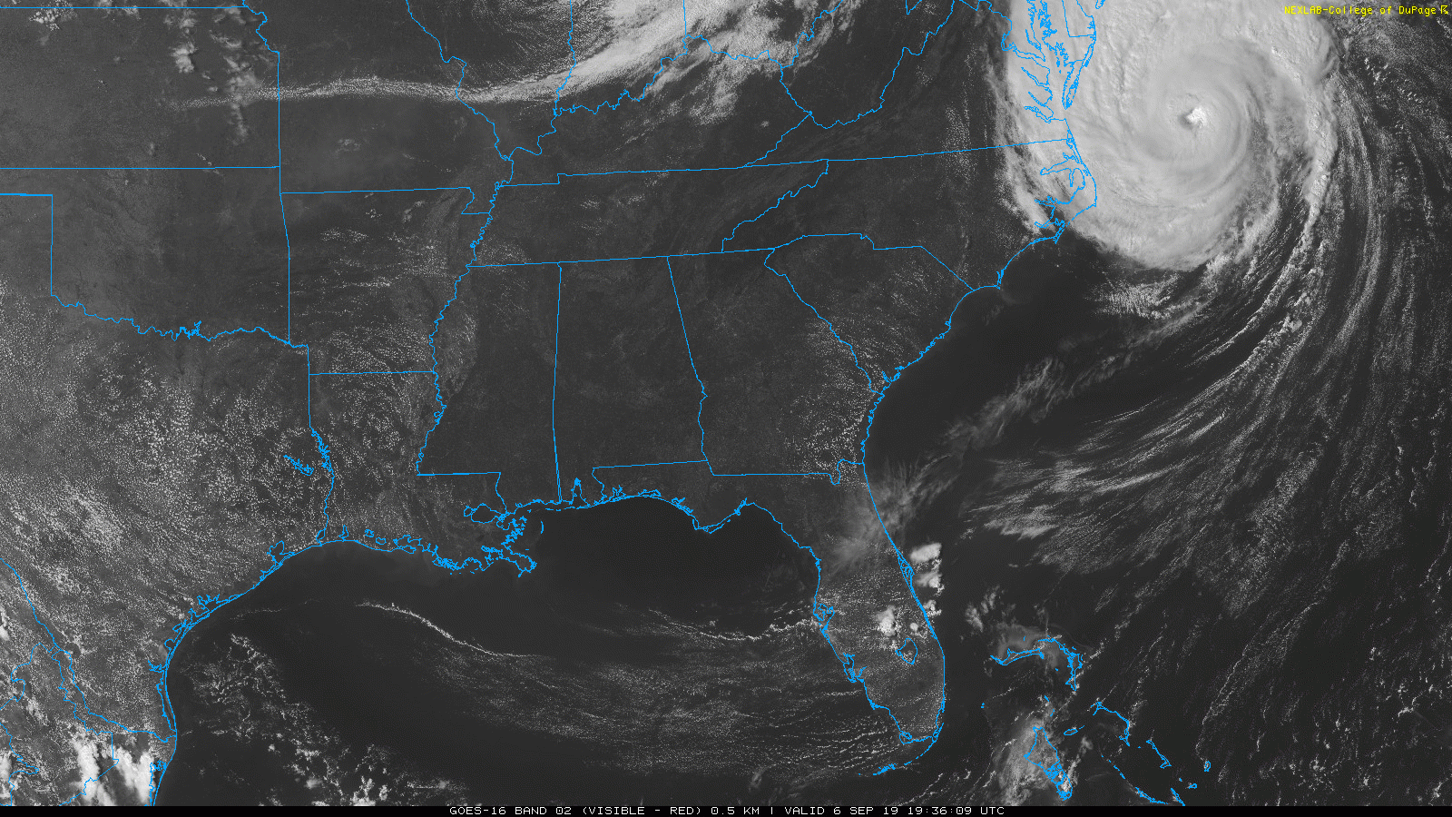
HURRICANE DORIAN: Now with sustained winds of 90 mph, the hurricane is finally moving away from the U.S. It will bring potential for hurricane conditions to parts of the Canadian Maritimes this weekend, then it becomes post-tropical over the North Atlantic next week.
TROPICAL STORM GABRIELLE: Rumors of Gabrielle’s death were greatly exaggerated. The system is back on the board in the Central Atlantic, and is expected to become a hurricane early next week. But, it remains far from land and is no threat to the U.S.
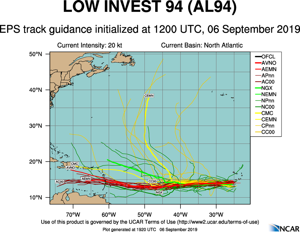
INVEST 94L: A well organized wave in the eastern Atlantic has a good chance of development over the next five days, and should become Tropical Storm Humberto within the next three days. Most global models bring it into the Caribbean next week, but it remains to be seen if this will impact the Gulf of Mexico, or the United States.
ON THIS DATE IN 2017: Category 5 Hurricane Irma affected the US Virgin Island and Puerto Rico. Maximum sustained winds were at 180 mph when the storm hit St. Thomas & St. John. Catastrophic damage was reported over the US Virgin Island & significant damage over Puerto Rico, especially over Culebra.
BEACH FORECAST: Click here to see the AlabamaWx Beach Forecast Center page.
WEATHER BRAINS: Don’t forget you can listen to our weekly 90 minute show anytime on your favorite podcast app. This is the show all about weather featuring many familiar voices, including our meteorologists here at ABC 33/40.
CONNECT: You can find me on all of the major social networks…
Facebook
Twitter
Instagram
Pinterest
Snapchat: spannwx
I had a great time today visiting with the third graders at Englewood Elementary in Tuscaloosa… be looking for them on the Pepsi KIDCAM today at 5:00 on ABC 33/40 News! My next Weather Xtreme video will be posted here by 7:00 a.m. Monday… enjoy the weekend!!!
Category: Alabama's Weather, ALL POSTS, Weather Xtreme Videos
About the Author (Author Profile)
James Spann is one of the most recognized and trusted television meteorologists in the industry. He holds the AMS CCM designation and television seals from the AMS and NWA. He is a past winner of the Broadcast Meteorologist of the Year from both professional organizations.Subscribe
If you enjoyed this article, subscribe to receive more just like it.


