Humberto Hitting Bermuda With Hurricane-Force Winds Possibly Into Early Thursday
SUMMARY & FORECAST DISCUSSION AS OF 4:00 PM CT
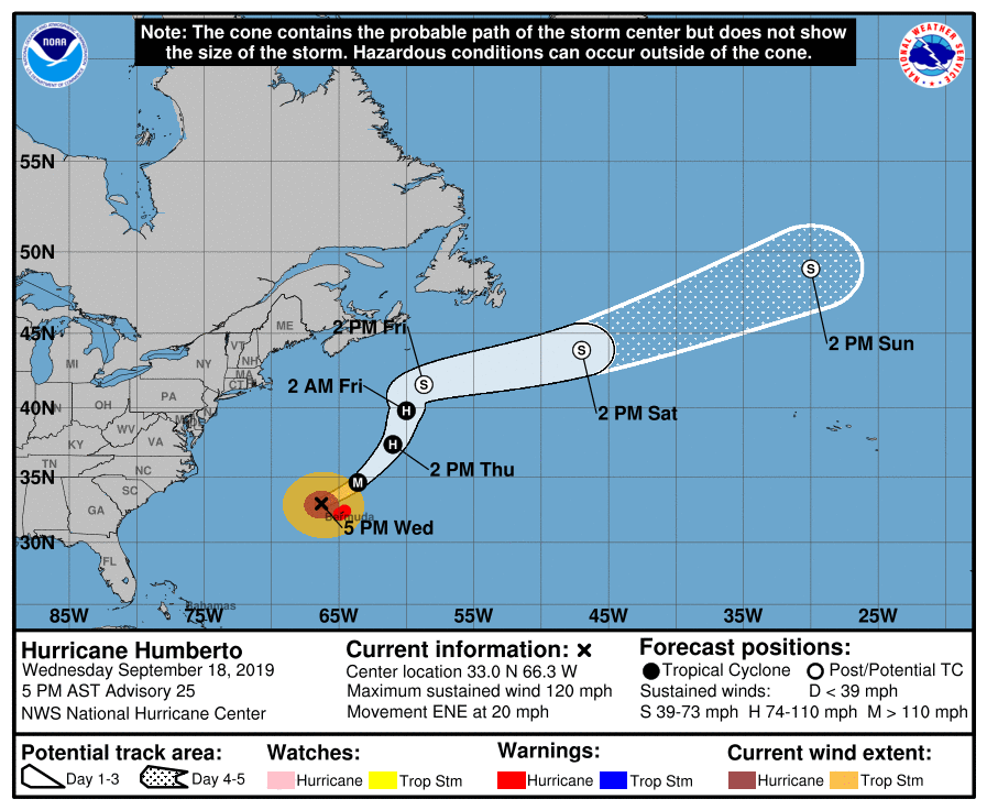
LOCATION…33.0N 66.3W
ABOUT 100 MI…160 KM WNW OF BERMUDA
MAXIMUM SUSTAINED WINDS…120 MPH…195 KM/H
PRESENT MOVEMENT…ENE OR 60 DEGREES AT 20 MPH…31 KM/H
MINIMUM CENTRAL PRESSURE…952 MB…28.12 INCHES
A Hurricane Warning is in effect for Bermuda
Normal communications with the Bermuda Weather Service have been disrupted due to a lightning strike.
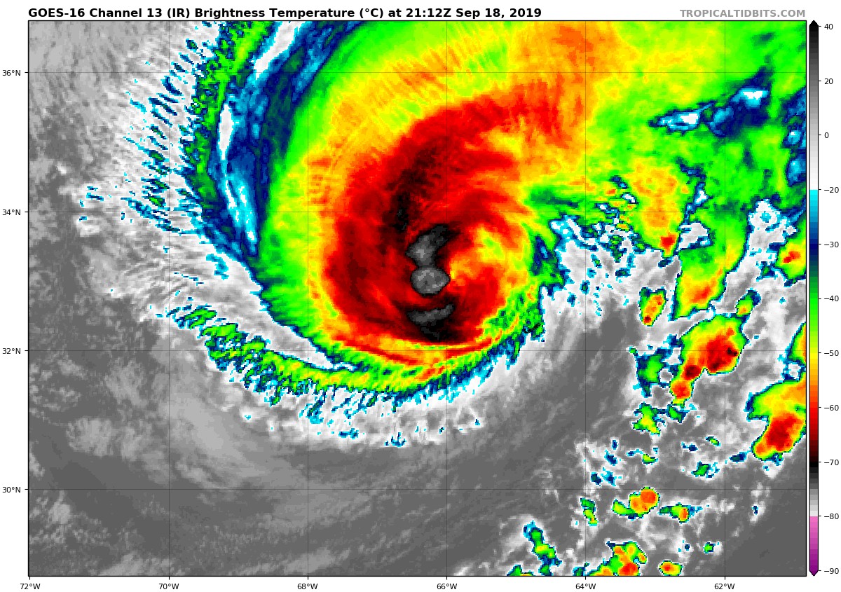
Humberto is taking on more of a hybrid-extratropical structure based on most of the rain shield having been displaced to the left or poleward side of the circulation now as seen in Bermuda weather radar data, and also in conventional and passive microwave satellite imagery. Sustained hurricane-force winds and gusts have been measured by amateur radio operators across the island, with a peak gust to 104 mph having been reported thus far at Ports Island, Bermuda. The initial intensity of 105 kt on the previous advisory has been maintained since little overall change in the structure has occurred since the last aircraft reconnaissance mission 6 hours ago.
The initial motion estimate is 060/17 kt. There are no significant changes to the previous forecast track or reasoning. Humberto has basically remained on track during the past 24 hours. The hurricane is expected to continue accelerating toward the east-northeast tonight and Thursday morning, with the center expected to pass about 80 nmi northwest of Bermuda early this evening. A turn toward the northeast and north-northeast is forecast to occur by early Thursday afternoon, followed by a motion toward the east-northeast by 48 hours, with the latter motion continuing through 96 hours. The new official track forecast is similar to the previous advisory track, and lies close to the tightly packed TVCN, NOAA-HCCA, and FSSE consensus track models.
Humberto is now fully embedded within an anticyclonically curved right-rear jet entrance region. As a result, some fluctuations in strength could occur during the next 12 hours or so. Thereafter, strong southwesterly vertical wind shear in excess of 50 kt, along with cold upwelling beneath the hurricane, should combine to induce steady weakening. By 48 hours, the global models continue to forecast Humberto to merge with a frontal system, and the NHC intensity forecast calls for extratropical transition around that time. The official intensity forecast follows an average of the global models’ intensity forecasts due to Humberto’s hybrid nature, which is not being captured properly by the tropical-cyclone-based consensus intensity models.
Key Messages:
1. A prolonged period of dangerous winds is expected to continue on Bermuda through Thursday morning, with hurricane-force winds expected during the next several hours. Preparations to protect life and property should be rushed to completion.
2. Storm surge and dangerous breaking waves could cause coastal flooding tonight and Thursday along the southern coast of Bermuda.
3. Swells will continue to affect the northwestern Bahamas and the southeastern coast of the United States from east-central Florida to North Carolina during the next couple of days, creating life-threatening surf and rip current conditions.
About the Author (Author Profile)
Scott Martin is an operational meteorologist, professional graphic artist, musician, husband, and father. Not only is Scott a member of the National Weather Association, but he is also the Central Alabama Chapter of the NWA president. Scott is also the co-founder of Racecast Weather, which provides forecasts for many racing series across the USA. He also supplies forecasts for the BassMaster Elite Series events including the BassMaster Classic.Subscribe
If you enjoyed this article, subscribe to receive more just like it.


