Heat and Dryness Continue for Foreseeable Future; Tropical Storm Karen Is on the Board
Our run of hot and dry weather continues across North and Central Alabama, and there is no relief in sight. Let’s look into the sizzling details.
SATURDAY HIGHS: It was 91F at Birmingham and Tuscaloosa, 90F at Calera, and 89F at Anniston. The average high for this time of year is 84F. So, it’s not ridiculously hot, but with Fall beginning officially tonight, everyone is ready for a little cooler weather. The good news is that the dewpoints are lower, and this is making things just a bit more comfortable. It’s a dry heat, you know. Yeah, that’s doesn’t make it much better.
FOR YOUR SUNDAY: Today will be sunny and hot, with afternoon highs centered around 90F. Dewpoints are right around 60F, so bordering on humid. Lows tonight will drop into the middle 60s. Rain chances will be right at zero.
NADA FOR MONDAY: no better chance on Monday with highs a couple of degrees warmer, around 92F.
TINY CHANCE TUESDAY: A front tries to sag into Alabama from the north by Tuesday, perhaps triggering a few scattered showers and storms. The chance if small, but we will take anything. Highs will be between 90F-92F.
SLIGHTLY BETTER CHANCE WEDNESDAY: It appears the front will inch ever so much closer by Wednesday, running our rain chances all the way to a whopping 20%.
RIDGE AND HEAT BUILDS: After that, the subtropical ridge should set up to our east and the heat/moisture pump will start to work again in earnest over the Southeast with a deep southerly flow. Humidity levels will be going up, and so will the mercury. Highs will start edging up, reaching into the lower and middle 90s into the weekend. Can’t rule out an isolated shower or storm, but don’t count on it.
THAT BUILDING RIDGE IS A CONCERN: Not only from a heat, humidity and fire concern, but also that Invest 99L could slip westward through the Caribbean as a tropical cyclone. That leads us into a little segment we call…
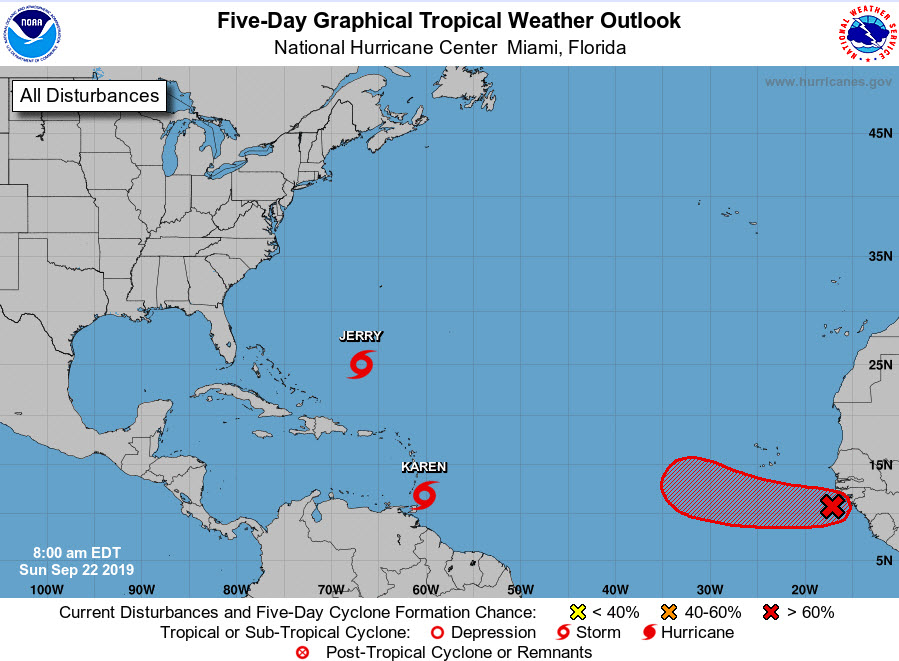
TALKIN’ TROPICS: Newly minted Tropical Storm Karen is located near the southern Windward Islands this morning. The system will move northwestward through the eastern Caribbean. But there are some signs that it could turn back to the west under a building ridge over the western Atlantic. As it does, it could affect the Bahamas and perhaps work into the…Gulf of Mexico. Could it spell increased rain chances for us around the weekend of the 5th? One can only hope.
JERRY: Bermuda may deal with a second tropical storm or hurricane by Tuesday. The current forecast is for it to be a tropical storm with top winds around
OUR NEXT DISTURBANCE: Is just coming off the coast of Africa. The system will probably become a hurricane during the next week as it tracks west-northwest and then northwest into the weakness left by Hurricane Jerry. This one should stay we east of Bermuda, and well east of everything else as well.
DROUGHT WORSENS: All this hot and dry weather will only worsen our drought and abnormally dry conditions. Out rainfall deficit at the Birmingham Airport had reached 5” by mid-August, but late August rains dented it a bit. Now we are approaching a 4-inch deficit over the past 90 days again. With less than an inch over the next two weeks and below normal rainfall into early November according to the longer range modeling. Brush and grass fires will become more common. Reservoir levels are dropping but aren’t critical yet. We have severe drought across Shelby County, with moderate drought conditions across Shelby/Chilton eastward through much of Talladega, Clay, Randolph, Coosa, Clay, and Tallapoosa counties.
GULF COAST WEATHER: Another gorgeous week along the beautiful beaches of Alabama and Northwest Florida. Highs will be in the upper 80s and lower 90s. lows will be in the middle 70s. Rain chances will be nearly nil all week. Water temperatures are running into the middle 80s. The rip current risk will be high today and Monday and moderate by Tuesday. Waves are running 3-4 feet.
Click here to see the Beach Forecast Center page.
WEATHER BY THE NUMBERS: The PRELIMINARY highest storm total rainfall amount of 43.15 inches in Jefferson County, TX would make #Imelda the 7th wettest tropical cyclone in United States history as well as the 4th wettest tropical cyclone ever to impact the state of Texas.
WEATHERBRAINS: This week, the panel will entertain Dr. Marshall Shepherd, a frequent contributor to the show. Check out the show at www.WeatherBrains.com. You can also subscribe on iTunes. You can watch the show live at live.bigbrainsmedia.com You will be able to see the show on the James Spann 24×7 weather channel on cable or directly over the air on the dot 2 feed.
ON THIS DATE IN 2002: The area around Birmingham was hard hit by flash flooding after very heavy rains fell during the early morning hours Three to five inches of rain fell in only a few hours, with some areas picking up over seven inches. Some of the worst damage was in the Vestavia and Mountain Brook areas. Follow my weather history tweets on Twitter. I am @wxhistorian at Twitter.com.
Category: Alabama's Weather, ALL POSTS
About the Author (Author Profile)
Bill Murray is the President of The Weather Factory. He is the site's official weather historian and a weekend forecaster. He also anchors the site's severe weather coverage. Bill Murray is the proud holder of National Weather Association Digital Seal #0001 @wxhistorianSubscribe
If you enjoyed this article, subscribe to receive more just like it.


