Sunny Saturday Afternoon
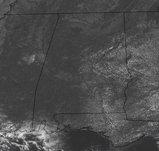
THE REST OF TODAY: After yet another very nice start the today, ample sunshine and dry conditions have allowed our temps to head into the 80s at midday, and by the end of the day we should see a range of upper 80s to the east with lower 90s to the south and west. Though temps remain above average by several degrees, the lower humidity and occasional easterly breeze have it feeling pretty nice outside.
SATURDAY NIGHT SPECIAL: Another very nice night of weather is ahead as temps will begin to fall pretty quick after sunset under a clear sky and by first thing tomorrow morning a temperature range of upper 50s in north and east Alabama to lower and mid 60s for central and western portions of the state are expected.
SUNNY SUNDAY: No real change in the forecast from today to tomorrow, with the exception of temps being a degree or two warmer by the afternoon. The sky should yet again feature ample sunshine and very tolerable humidity levels, meaning the mainly lower 90s for highs, won’t be feeling that bad.
IN THE TROPICS: Jerry is back to tropical storm status for now, but is expected to regain hurricane strength in the coming days and looks to be a real threat to the island of Bermuda by Tuesday and Wednesday. The latest update from the NHC has the center of Tropical Storm Jerry was located near latitude 22.0 North, longitude 65.0 West. Jerry is moving toward the northwest near 14 mph, and this general motion is expected to continue today. Jerry is forecast to turn northward on Sunday and then accelerate northeastward early next week. On the forecast track, the center of Jerry will continue pass well north Puerto Rico today and pass well east of the southeastern Bahamas on Sunday.
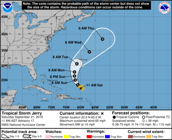
Data from an Air Force Reserve hurricane hunter plane indicate that the maximum sustained winds of Jerry remain near 65 mph with higher gusts. Little change in strength is forecast during the next several days. Tropical-storm-force winds extend outward up to 90 miles from the center. The estimated minimum central pressure based on data from the hurricane hunter plane is 999 mb (29.50 inches).
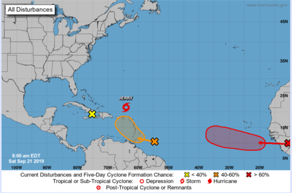
ELSEWHERE IN THE TROPICS: A tropical wave located several hundred miles east of the Windward Islands is producing a large area of showers and thunderstorms. The wave is forecast to move quickly westward to west-northwestward at 15 to 20 mph for the next day or two, crossing the Windward Islands on Sunday. Although the system is currently disorganized, environmental conditions appear to be conducive for some development and a tropical depression could form later this weekend or early next week. A NOAA Hurricane Hunter aircraft is scheduled to investigate this system this afternoon. Regardless of development, heavy rainfall is possible over much of the Lesser Antilles over the weekend, and interests on those islands and Puerto Rico should monitor the progress of this disturbance. Formation chance through 48 hours…medium…50 percent. Formation chance through 5 days…medium…60 percent.
A broad area of low pressure centered near the eastern tip of Cuba continues to produce only disorganized showers and thunderstorms. Significant development of this system is not expected while it moves slowly west-northwestward during the next couple of days due to strong upper-level winds and interaction with land. Regardless of development, locally heavy rainfall is likely over portions of Hispaniola, Jamaica, and Cuba through the weekend, potentially causing flash flooding and mudslides in areas of high terrain. Formation chance through 5 days…low…near 0 percent.
A tropical wave is forecast to move off the west coast of Africa by Sunday. Environmental conditions are expected to be conducive for development, and a tropical depression or tropical storm is likely to form early next week while the wave moves westward across the eastern tropical Atlantic. Formation chance through 48 hours…medium…40 percent. Formation chance through 5 days…high…90 percent.
BEACH FORECAST CENTER: Get the latest weather and rip current forecasts for the beaches from Fort Morgan to Panama City on our Beach Forecast Center page. There, you can select the forecast of the region that you are interested in visiting.
WORLD TEMPERATURE EXTREMES: Over the last 24 hours, the highest observation outside the U.S. was 116.6F at Arafat, Saudi Arabia. The lowest observation was -93.5F at Dome A, Antarctica.
CONTIGUOUS TEMPERATURE EXTREMES: The highest observation was 108F at Rio Grande Village, TX. The lowest observation was 19F at Harbison Meadow, CO.
WEATHER ON THIS DATE IN 1954: The temperature at Deeth, NV, soared from a morning low of 12 degrees to a high of 87 degrees, a record daily warm-up for the state.
Category: Alabama's Weather, ALL POSTS
About the Author (Author Profile)
Macon, Georgia Television Chief Meteorologist, Birmingham native, and long time Contributor on AlabamaWX. Stormchaser. I did not choose Weather, it chose Me. College Football Fanatic. @Ryan_StinnetSubscribe
If you enjoyed this article, subscribe to receive more just like it.


