Next Cold Front Arrives Saturday
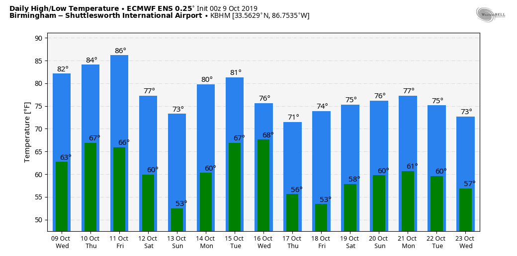
ONLY ISOLATED SHOWERS TODAY: Temperatures are in the 50s over much of North Alabama early this morning; we rise into the low to mid 80s today with a partly sunny sky. A few showers are possible this afternoon, but they should be few and far between and most communities will stay dry. Not much change tomorrow; partly sunny with a warm afternoon… the high will be in the mid 80s.
FRIDAY AND THE WEEKEND: The day Friday will be warm and dry; with a mix of sun and clouds afternoon temperatures will reach the low to mid 80s. Clouds increase Friday night, and a few showers could push into West Alabama ahead of a cold front.
Saturday will be mostly cloudy and much cooler; some places over Northwest Alabama could hold in the 50s all day… other North/Central Alabama communities will be in the 60s. We will mention a chance of showers, but it won’t be a “wash out”… rain amounts should be fairly light.
Uncertainly is creeping into the forecast for Sunday. The European global model is now suggesting moist air will ride up and over the cooler air at the surface, potentially setting the stage for some rain by Sunday afternoon or Sunday night. The GFS (American) model remains dry; for now will forecast a partly sunny day, and mention just an outside risk of a shower Sunday afternoon… but this is now a low confidence forecast that could change as we get closer to the weekend. The high Sunday should be in the low 70s.
NEXT WEEK: Monday and Tuesday look generally cloudy, and there will be some chance of rain both days, although for the moment it looks like the best chance will come Tuesday. The latter half of the week looks dry and pleasant… See the Weather Xtreme video for maps, graphics, and more details.
TROPICS: A potent hybrid storm system is developing off the U.S. east coast… it will linger offshore for a few days and will bring very rough surf and strong wind gusts to the upper half of the Atlantic coast in coming days. Another disturbance in the Central Atlantic has a medium chance of becoming a depression or storm over the next few days, but it is far from land. The Gulf of Mexico remains quiet.
RACE WEEKEND AT TALLADEGA: A few showers are possible around the Superspeedway late Friday night or Saturday… rain amounts should be light and spotty. The forecast for Sunday is now a bit uncertain; for now we will forecast a mix of sun and clouds with only an outside risk of some light rain during the big race. The high Saturday will be in the mid to upper 60s, followed by low 70s Sunday. Sunday morning will be chilly with lows in the upper 40s.
FOOTBALL WEATHER: For the high school games Friday night, the sky will be mostly cloudy, and scattered showers are possible. Temperatures will be in the 70s at kickoff, falling into the 60s by the fourth quarter.
Alabama travels to College Station to take on the Texas A&M Aggies (2:30p CT kickoff)… the sky will be sunny with a kickoff temperature near 71 degrees.
UAB will also be in Texas Saturday; they play at UTSA (5:00p CT kickoff). Temperatures will fall from near 70 at kickoff, through the 60s during the game with a brisk northwest breeze (although the game will be played in a dome). Mostly fair; no risk of rain.
Jacksonville State will take on Eastern Illinois Saturday (12:00 noon CT kickoff) in Charleston, IL… the day will be cool and dry with mid 50s at kickoff; sunshine will be in full supply during the game.
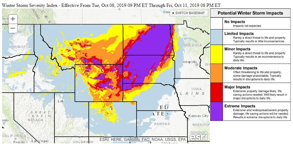
BIG SNOW EVENT AHEAD FOR THE NORTHERN U.S.: A huge early season snow event will unfold in coming days from Montana and Wyoming, over into the Dakotas. The Winter Storm Severity Index is an experimental product that summarizes many winter hazards and has recently been expanded to the entire Lower 48. It is indicating that extreme impacts are expected from parts of the Rockies and Northern Plains.
ON THIS DATE IN 2001: An unusually strong fall outbreak of tornadoes spawned at least 23 twisters across parts of Nebraska and Oklahoma. Hardest hit was the town of Cordell, OK, but a 22 minute lead time led to an amazingly low casualty count: only nine injuries and no fatalities.
BEACH FORECAST: Click here to see the AlabamaWx Beach Forecast Center page.
WEATHER BRAINS: Don’t forget you can listen to our weekly 90 minute show anytime on your favorite podcast app. This is the show all about weather featuring many familiar voices, including our meteorologists here at ABC 33/40.
CONNECT: You can find me on all of the major social networks…
Facebook
Twitter
Instagram
Pinterest
Snapchat: spannwx
I have a weather program this morning at Greensboro Elementary… look for the next Weather Xtreme video here by 4:00 this afternoon. Enjoy the day!
Category: Alabama's Weather, ALL POSTS, Weather Xtreme Videos
About the Author (Author Profile)
James Spann is one of the most recognized and trusted television meteorologists in the industry. He holds the AMS CCM designation and television seals from the AMS and NWA. He is a past winner of the Broadcast Meteorologist of the Year from both professional organizations.Subscribe
If you enjoyed this article, subscribe to receive more just like it.


