Big Soaking For Much Of Alabama Tomorrow
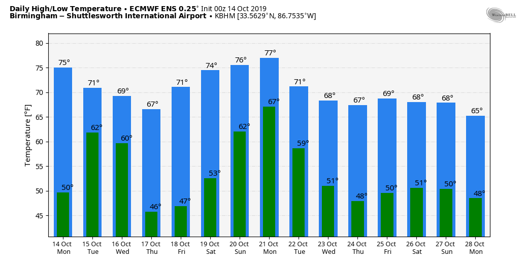
SHOWERS OVER SOUTH ALABAMA TODAY: On the maps this morning we have a stalled front over the southern counties of the state; we will maintain the chance of showers today, mostly south of U.S. 80. North Alabama will experience a mix of sun and clouds with a high in the mid 70s. Clouds increase statewide tonight, with showers possible after midnight.
RACE WEATHER FOR TALLADEGA: The suspended race will resume today at 1:00p CT… the sky will be partly sunny with temperatures in the low to mid 70s. No risk of rain.
TUESDAY SOAKER: A big rain event is likely for most of the state tomorrow as the surface front creeps northward as a warm front, and moist air is transported over the front. The heaviest rain is likely over the southern 2/3 of Alabama, with amounts of 1 to 3 inches likely. WPC even forecasts some risk of flash flooding (despite the recent drought)…
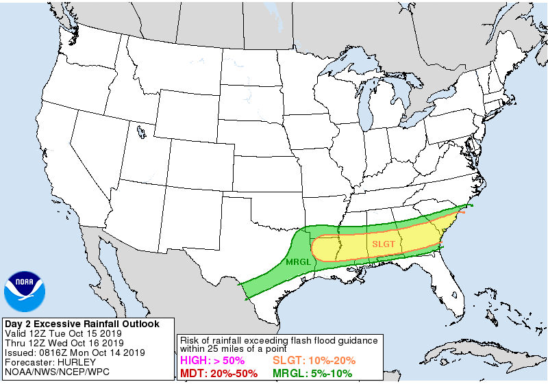
Amounts over the Tennessee Valley of North Alabama will be in the 1/2 to 1 inch range. Some thunder is possible tomorrow, but for now severe storms are not expected due to the lack of surface based instability. Temperatures will hold in the 60s all day as the rain falls.
REST OF THE WEEK: Any lingering showers will end early Wednesday, and the sky becomes partly sunny during the day with a high in the 67-70 degree range. Thursday and Friday will offer some perfect fall weather, with sunny pleasant days and clear cool nights. Lows will be generally in the low to mid 40s, but colder pockets could see upper 30s. The high Thursday will be in the upper 60s, followed by mid 70s Friday.
THE ALABAMA WEEKEND: Saturday looks dry and mild with a high in the upper 70s; clouds increase Saturday night, and Sunday looks somewhat unsettled with a chance of showers and thunderstorms as moist, unstable air moves into the state from the south. The high Sunday afternoon will be close to 80 degrees.
NEXT WEEK: A rather dynamic system will bring a good chance of showers and strong thunderstorms to Alabama Monday… keep in mind we are nearing the late fall severe weather season in Alabama (November and December). Cooler, drier air returns for mid-week… See the Weather Xtreme video for maps, graphics, and more details.
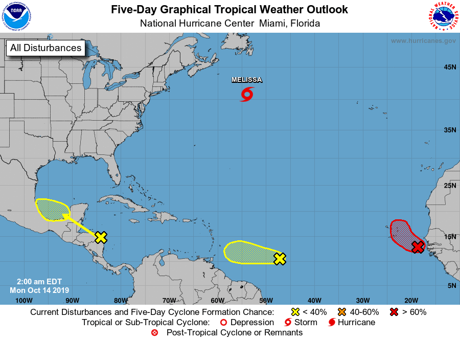
TROPICS: Tropical Storm Melissa is expected to dissipate in the North Atlantic, far from land, by tomorrow night. A new wave coming off the coast of Africa has a high chance of development over the next 48 hours, but it will gain latitude and for now doesn’t seem to be a threat to the Lesser Antilles or the U.S.
ON THIS DATE IN 1941: America’s first television weather forecast was broadcast on New York’s WNBT (later WNBC). There weren’t many televisions at that time, so viewers were limited to perhaps a few hundred people. The weathercast consisted of a sponsor’s message followed by a screen of text containing the next day’s forecast.
BEACH FORECAST: Click here to see the AlabamaWx Beach Forecast Center page.
WEATHER BRAINS: Don’t forget you can listen to our weekly 90 minute show anytime on your favorite podcast app. This is the show all about weather featuring many familiar voices, including our meteorologists here at ABC 33/40.
CONNECT: You can find me on all of the major social networks…
Facebook
Twitter
Instagram
Pinterest
Snapchat: spannwx
Look for the next Weather Xtreme video here by 4:00 this afternoon… enjoy the day!
Category: Alabama's Weather, ALL POSTS, Weather Xtreme Videos
About the Author (Author Profile)
James Spann is one of the most recognized and trusted television meteorologists in the industry. He holds the AMS CCM designation and television seals from the AMS and NWA. He is a past winner of the Broadcast Meteorologist of the Year from both professional organizations.Subscribe
If you enjoyed this article, subscribe to receive more just like it.


