

Dry Air Returns Tomorrow; Eyes On The Western Gulf
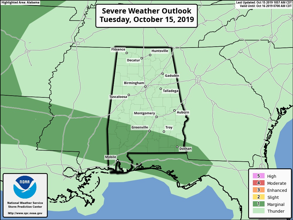
WET DAY: Rain covers much of Alabama this afternoon; so far the heavier totals have been over the southern half of the state, close to a stalled front. Rain will continue at times through tonight, and potential for strong storms remains over far South Alabama, where unstable air is in place. SPC maintains a “marginal risk” (level 1/5) for areas south of a line from Sweetwater to Greenville to Abbeville.
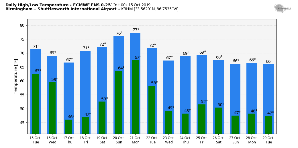
Rain will end early tomorrow morning, and the sky becomes sunny by mid to late morning as a nice surge of dry air blows into the state. The high tomorrow will be close to 70 degrees.
THURSDAY/FRIDAY: We project perfect autumn weather on these two days with sunny pleasant days and clear chilly nights. The low early Thursday and Friday will be in the 40-45 degree range, but colder spots will visit the 30s. The high Thursday will be in the upper 60s, followed by low 70s Friday.
THE ALABAMA WEEKEND: No doubt we will have some rain over the weekend, but details remain unclear. Here are the main weekend forecast points now…
*NHC is forecasting a medium chance of tropical depression or storm development in the western Gulf of Mexico by Thursday and Friday. Models take this disturbance into the Deep South over the weekend, and this could enhance the amount of rain we see. But, needless to say, there is no way now of knowing the exact placement of the axis of heavier rain since the tropical system is over land at the moment (the southern Yucatan Peninsula of Mexico). Once it gets into the Gulf and becomes organized, we will be able to provide a much more detailed forecast.
*It won’t rain all weekend. For now, it looks like rain begins across South Alabama Saturday morning, and spreads northward to cover much of the state by late Saturday afternoon, Saturday night, and into Sunday morning. If the tropical system does get involved, the rain could be heavy at times.
*Highs will be in the 70s both Saturday and Sunday.
NEXT WEEK: A cold front will bring another chance of showers and thunderstorms to Alabama Monday. The air will be unstable, and this could set the stage for strong, possibly severe thunderstorms. Again, way too early to be specific. Then, cooler, drier air rolls in during the middle of the week after the front passes. See the Weather Xtreme video for maps, graphics, and more details.
TD 15: The depression in the far eastern Atlantic is now expected to remain below tropical storm strength, and it should dissipate far from land by the weekend.
FOOTBALL WEATHER: Auburn travels to Fayetteville, Arkansas to take on the Razorbacks Saturday (11:00a CT kickoff)… the sky will be partly sunny, and there is an outside risk of a passing shower or thunderstorm during the game. Kickoff temperature near 68, rising into the low 70s by the second half.
Alabama will host Tennessee Saturday night at Bryant-Denny Stadium in Tuscaloosa (8:00p CT kickoff)… the sky will be cloudy, and some rain is likely during the game. Temperatures will be in the low 70s.
UAB hosts Old Dominion Saturday afternoon at Legion Field in Birmingham (3:00p CT kickoff)… the sky will be mostly cloudy, and rain could move in during the game. Kickoff temperature will be near 77 degrees, falling back into the low 70s by the final whistle.
Jacksonville State hosts Southeast Missouri State Saturday (3:00p CT kickoff)… the sky will be mostly cloudy; rain is possible. Temperatures will fall from near 76 at kickoff, into the low 70s by the fourth quarter.
ON THIS DATE IN 1984: The Monday Night Football game in Denver, CO was played in a raging blizzard. 15 inches of snow fell with up to 34 inches reported in the nearby mountains. The Air Force Academy canceled classes for the first time in its’ recorded history.
BEACH FORECAST: Click here to see the AlabamaWx Beach Forecast Center page.
WEATHER BRAINS: Don’t forget you can listen to our weekly 90 minute show anytime on your favorite podcast app. This is the show all about weather featuring many familiar voices, including our meteorologists here at ABC 33/40.
CONNECT: You can find me on all of the major social networks…
Facebook
Twitter
Instagram
Pinterest
Snapchat: spannwx
I enjoyed seeing the students at God’s House Kindergarten at Altadena Valley Presbyterian Church in Birmingham, and the 5th graders at Good Hope Elementary in Cullman County today… be looking for them on the Pepsi KIDCAM today at 5:00 and 6:00 on ABC 33/40 News! The next Weather Xtreme video will be posted here by 7:00 a.m. tomorrow…
Category: Alabama's Weather, ALL POSTS, Weather Xtreme Videos
About the Author (Author Profile)
James Spann is one of the most recognized and trusted television meteorologists in the industry. He holds the AMS CCM designation and television seals from the AMS and NWA. He is a past winner of the Broadcast Meteorologist of the Year from both professional organizations.Subscribe
If you enjoyed this article, subscribe to receive more just like it.


