

What NWS Birmingham Thinks About Today’s Severe Threat
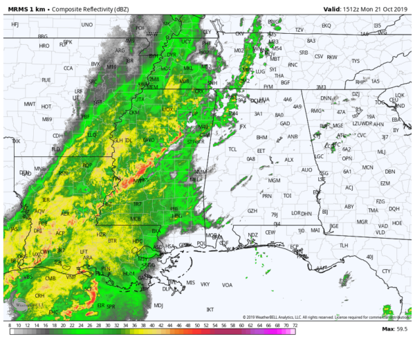
Radar composite as of 10:15 am this morning.
The latest severe weather update from NWS Birmingham is out as they have just completed a conference call with emergency management and decision-makers throughout Central Alabama. Here is what was discussed in that call…
• NWS Birmingham has a Marginal Risk for severe storms up for all of Central Alabama through the day and into the late-night hours tonight.
• The main threat continues to be isolated damaging straight-line thunderstorm winds up to 60 MPH, but an isolated tornado can not be ruled out.
• Timing for stronger to severe storms remains to be from noon today through midnight tonight. West of a line from Hanceville to Brookwood to Demopolis will be from 12:00 pm to 5:00 pm. East of that to a line stretching from Fruithurst to Alexander City to Fort Deposit will be from 4:00 pm to 8:00 pm. East of that will be from 7:00 pm to 12:00 am.
• Best instability will remain across the southern portions of the area and down into South Alabama and the Gulf Coast.
• Storms developing over the Gulf Coast at the moment may inhibit energy from reaching Central Alabama and may reduce the severe risks.
• Current cloud cover and any stratiform rain that occurs will also help inhibit instability somewhat across the area.
• Line of storms in Mississippi is currently in a weakening phase as it moves east and eventually into the western portions of the area.
• Some storms may redevelop during the afternoon and early evening hours, especially over the southern and southeastern locations in Central Alabama.
So, we could see this main line of showers and storms weaken and dissipate somewhat throughout the remainder of the morning and into the early afternoon, but some redevelopment could occur with the main heating of the day during the afternoon and early evening hours. We’ll have to watch and see what the storms do over the Gulf Coast. If a good bit of activity forms down there, that would greatly reduce our severe storm potential by cutting off the flow of energy. If those storms do not develop across the coast, then we’ll continue to have the potential for strong to severe storms during the day.
This is one we’ll have to keep our eyes on throughout the day. The good news is that this is not expected to be a major severe weather event. No matter the expectations, you still have to be prepared just in case. We’ll continue to have updates throughout the day.
Category: Alabama's Weather, ALL POSTS, Severe Weather
About the Author (Author Profile)
Scott Martin is an operational meteorologist, professional graphic artist, musician, husband, and father. Not only is Scott a member of the National Weather Association, but he is also the Central Alabama Chapter of the NWA president. Scott is also the co-founder of Racecast Weather, which provides forecasts for many racing series across the USA. He also supplies forecasts for the BassMaster Elite Series events including the BassMaster Classic.Subscribe
If you enjoyed this article, subscribe to receive more just like it.


