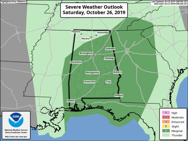
SPC Now Has Marginal Risk Up For Nearly All Of Central Alabama On Saturday
From the Storm Prediction Center…
THERE IS A MARGINAL RISK OF SEVERE THUNDERSTORMS CENTERED OVER ALABAMA, GEORGIA, AND THE FLORIDA PANHANDLE ON SATURDAY.
SUMMARY
Isolated severe storms are possible Saturday over parts of the Southeast. A brief tornado is possible, along with a few damaging wind gusts.
Synopsis and Discussion
A shortwave trough will move rapidly northeast from the Arklatex to the upper Great Lakes, with a 90 kt mid-level speed max centered over the mid-MS Valley by 21Z. At the surface, a low will move from northeast AR across IL, with a cold front extending south and progressing across MS and AL during the day. Meanwhile, a warm front will lift north across northern AL and GA, with upper 60s F dewpoints nearing the TN border and low 70s to the south. Strong low-level shear will develop across the warm sector and especially near the warm front, aided by southerly 850 MB winds over 50 kt.
The primary zone of height falls will spread across the OH Valley, but will also influence parts of AL and GA where sufficient instability will develop to support thunderstorms. Storms are likely to be ongoing Saturday morning along the cold front from eastern MS into western AL, extending south to the Gulf Coast. Areas of heating are expected over AL and GA behind the warm front, and this warming air mass will spread northwest toward the front. The greatest severe risk is thus expected to be from central into northeast AL and across central and northern GA where strong shear profiles will exist coincident with up to 500 J/kg MUCAPE. The severe risk may extend farther north into eastern TN/western NC depending on destabilization, as this area will experience the most persistent large-scale ascent. Models suggest increasing storm intensity along the front as it traverses AL and GA, with QLCS tornado or wind potential. Weak instability due to warm temperatures aloft will be the main mitigating factor to greater severe potential.
Other sporadic strong storms are possible over southern areas of AL, GA, and the FL Panhandle where heating will contribute to better instability, although shear will be less than points north.
Category: Alabama's Weather, ALL POSTS, Severe Weather
About the Author (Author Profile)
Scott Martin is an operational meteorologist, professional graphic artist, musician, husband, and father. Not only is Scott a member of the National Weather Association, but he is also the Central Alabama Chapter of the NWA president. Scott is also the co-founder of Racecast Weather, which provides forecasts for many racing series across the USA. He also supplies forecasts for the BassMaster Elite Series events including the BassMaster Classic.Subscribe
If you enjoyed this article, subscribe to receive more just like it.


