Another 2-4 Inches Possible For The Western Half Of Central Alabama?
The latest Mesoscale Precipitation Outlook is out for the area from the WPC, and it shows the potential for more heavy rainfall and the potential for some flash flooding issues. Here is the text from the MPO:
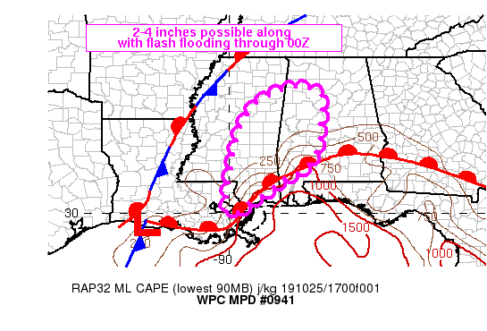
Summary
Repeating and short term training will provide an increased threat for flash flooding rainfall from portions of far southeastern LA into MS and western AL through 00Z. Maximum rainfall totals of 2-4 inches will be possible where ideal cell training sets up.
Discussion
Radar trends over the past 1-2 hours have shown robust convective development over southern MS into western AL, immediately on the cool side of a warm front lifting north from the Gulf Coast. The warm front marks the leading edge of deeper low-level moisture with surface dewpoints in the lower to middle 70s south of the front with upper 50s to 60s located north of the boundary. Visible satellite imagery showed some breaks in cloud cover within the warm sector from the Mississippi coast to the western FL Panhandle which has allowed estimated MLCAPE to rise in the 1000-1500 J/kg range via the latest SPC mesoanalysis.
CIRA Layered PW is deep across the area in advance of T.D. Seventeen located in the west-central Gulf, and the axis of highest moisture will continue to point toward the central Gulf Coast through at least 00Z. GPS observed values along the coast ranged from 2.1 to 2.3 inches, and when combined with the instability, could easily support rainfall rates of 2-3 in/hr.
Flow is unidirectional from the south which will support the training of cells at times, some of which have already been observed as near I-59 in southern MS and north of Mobile in southern AL. Despite some slight weakening of low-level wind speed magnitude through 00Z, as forecast by the RAP, changes to wind direction and speed should not be significant enough to disrupt the potential for elements of training within the broader precipitation shield. Only slow northward movement of the warm front is expected through 00Z, likely translating into repeating rounds of heavy rain to the north of the broken cloud cover just north of the warm frontal boundary. Some Flash Flood Guidance (FFG) values across the MPD threat area were as low as 1.5-2.5 inches in three hours which has the potential to be exceeded. surrounding the pocket of lower FFG, values remain relatively low at 2.5+ inches in three hours. Flash flooding will remain an enhanced possibility over the next several hours.
Category: Alabama's Weather, ALL POSTS, Severe Weather
About the Author (Author Profile)
Scott Martin is an operational meteorologist, professional graphic artist, musician, husband, and father. Not only is Scott a member of the National Weather Association, but he is also the Central Alabama Chapter of the NWA president. Scott is also the co-founder of Racecast Weather, which provides forecasts for many racing series across the USA. He also supplies forecasts for the BassMaster Elite Series events including the BassMaster Classic.Subscribe
If you enjoyed this article, subscribe to receive more just like it.


