

A Nice Sunday in Progress, Rain Monday Night, Much Colder Tuesday and Wednesday
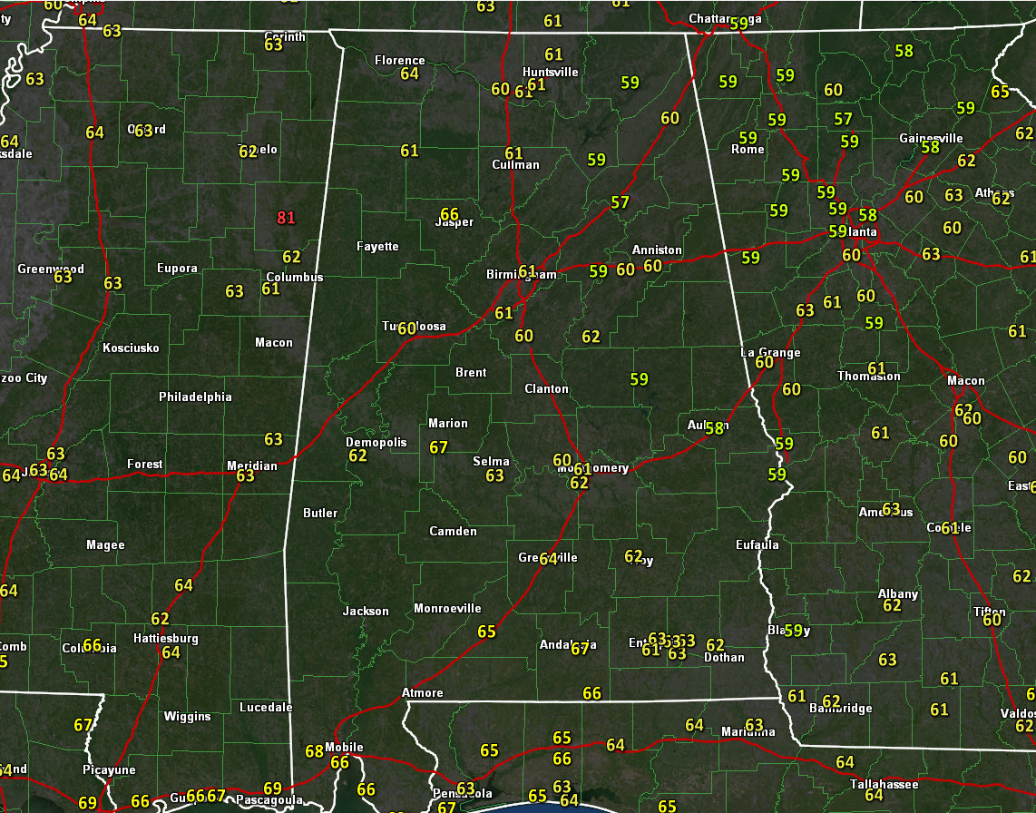
A nice Sunday is in progress across Alabama. Clear skies are in place, morning fog in the river valleys has burned off, and temperatures are climbing into the lower 60s.
HIGH PRESSURE IN CONTROL FOR NOW Surface high pressure extends from near Charleston and Savannah to near Montgomery early this afternoon. The nearest rainfall to Alabama is some light showers off the Outer Banks of North Carolina and a few snowflakes over northern Illinois and southern Wisconsin. Readings will top out between 62-68F across the northern half of the state. Skies will remain fair through the afternoon, with a few more clouds showing up overnight. Lows tonight will be in the lower 40s.
TRANSIT OF MERCURY: Our solar system’s innermost planet, Mercury, will pass directly in front of the sun tomorrow. It will be visible here, but you have to have a telescope or binoculars with the right solar filters installed to view it safely. It’ll come into view as a small black dot on the sun’s face around 6:36 a.m. CST Monday morning. It’ll make a 5.5-hour journey across the sun’s face, reaching the greatest transit (closest to the sun’s center) at approximately 9:20 a.m. CST (15:20 UTC) and finally exiting around 12:04 p.m. CST (18:04 UTC). Much of the world can see some part of the transit. The entire transit will be visible across the U.S. East – with magnification and proper solar filter. For more information on how to view the transit safely, visit the Earth and Sky website.
VETERAN’S DAY: As we honor our vets tomorrow, it will be increasingly cloudy, but mild, with highs in the upper 60s. A few showers will appear by Monday afternoon over northwestern sections, but it will take until late afternoon for them to reach the I-59 Corridor. Rain will become likely Monday night, pushing southeastward through the overnight hours. Winds will shift to northwesterly behind a strong cold front during the late-night hours. Rainfall amounts should be between one half and one inch across the area.
TUESDAY WILL NOT BE NICE: We start off near freezing with a strong northwesterly wind. Temperatures will struggle to get out of the 30s despite a clearing sky.
HARD FREEZE TUESDAY NIGHT: And the mercury will drop like a rock Tuesday evening, reaching the teens over North Alabama by Wednesday morning. Lows will be in the lower 20s across Central Alabama, with a freeze all the way to the coast. A hard freeze is expected for areas along and north of I-20, and watches and warnings could be required as we get closer to the event.
Category: Alabama's Weather, ALL POSTS
About the Author (Author Profile)
Bill Murray is the President of The Weather Factory. He is the site's official weather historian and a weekend forecaster. He also anchors the site's severe weather coverage. Bill Murray is the proud holder of National Weather Association Digital Seal #0001 @wxhistorianSubscribe
If you enjoyed this article, subscribe to receive more just like it.


