A Dry Spell Starts Today, Shower Chances Return On Friday
FANTASTIC BUT COOL SATURDAY
Today will be a much brighter day across all of Central Alabama compared to Friday as the disturbance has moved to our east and will continue to move out over the Atlantic. That means for us sunny skies with cool temperatures. Afternoon highs will top out in the mid-50s to the lower 60s. Skies will remain clear throughout the night with lows dropping into the upper 20s to the upper 30s.
A LITTLE WARMER ON SUNDAY
We’ll have a few clouds move across the sky throughout the day on Sunday, but we’ll stay generally mostly sunny. No rain to be expected and highs will be a little warmer, up into the upper 50s to the mid-60s.
A FEW MORE CLOUDS ON MONDAY
We’ll continue to stay dry on Monday but we’ll have even more clouds move across Central Alabama. It will be partly to mostly cloudy at times with highs reaching the lower 50s to the lower 60s.
BRIGHTER ON TUESDAY
The quiet weather trend continues on Tuesday as those clouds will finally move out of the area and we’ll be left with mainly sunny skies throughout the day. Highs will be in the upper 50s to the mid-60s.
VERY NICE DAY ON WEDNESDAY
We’ll stay dry on Wednesday, plus it will be just a little warmer. Skies will be mostly sunny and highs will be in the mid-60s to the lower 70s across Central Alabama.
CLOUDS MOVE BACK IN ON THURSDAY
A cold front will be approaching from the west on Thursday that will send clouds into Central Alabama. At this point, we look to stay dry with mostly cloudy skies. Afternoon highs will be in the mid-60s to the lower 70s.
SHOWERS POSSIBLE ON FRIDAY
The cold front will move into the northern parts of the state on Friday which will bring a chance of showers to the area with the higher chances north of the I-85 corridor. Not everyone will see rain, but rainfall amounts look to range from a trace to as high as 1/2-inch from southeast to northwest. Thunder does not look likely as there is no instability to work with. Highs will be in the upper 50s to the upper 60s.
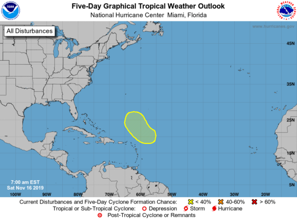
THE TROPICS
We do have one area of concern that is expected to form in the tropics a few hundred miles to the northeast of the Leeward Islands either late this weekend or early next week. It will be no threat to land as it will move northwest and north over the open waters of the Atlantic and eventually merging with a frontal system near the end of the week. The National Hurricane Center doesn’t believe this will develop into a tropical cyclone.
ON THIS DAY IN WEATHER HISTORY
2006 – An F-3 tornado strikes Riegelwood, NC causing eight deaths and twenty injuries.
BEACH FORECAST
Get the latest weather and rip current forecasts for the beaches from Bay St. Louis, MS, to Panama City Beach, FL, on our Beach Forecast Center page. There, you can select the forecast of the region that you are interested in.
ALREADY OFF TO A HOT START IN 2019! ADVERTISE WITH THE BLOG!
After a record-setting 2018 with nearly 20 million page views, AlabamaWx.com is already well on its way to another great year as we’ve just topped 14.7 million page views so far in 2019! Don’t miss out! We can customize a creative, flexible and affordable package that will suit your organization’s needs. Contact Bill Murray at (205) 687-0782.
E-FORECAST
Get the Alabama Wx Weather Blog’s Seven-Day Forecast delivered directly to your inbox by email twice daily. It is the most detailed weather forecast available in Central Alabama. Subscribe here… It’s free!
CONNECT WITH THE BLOG ON SOCIAL MEDIA
You can find the AlabamaWx Weather Blog on the major social media networks:
Facebook
Twitter
Instagram
WEATHERBRAINS
Don’t forget you can listen to our weekly 90 minute netcast anytime on the web at WeatherBrains.com or on Apple Podcasts, Stitcher, or Spotify. This is the show all about weather featuring many familiar voices, including the meteorologists at ABC 33/40.
Category: Alabama's Weather, ALL POSTS, Weather Xtreme Videos
About the Author (Author Profile)
Scott Martin is an operational meteorologist, professional graphic artist, musician, husband, and father. Not only is Scott a member of the National Weather Association, but he is also the Central Alabama Chapter of the NWA president. Scott is also the co-founder of Racecast Weather, which provides forecasts for many racing series across the USA. He also supplies forecasts for the BassMaster Elite Series events including the BassMaster Classic.Subscribe
If you enjoyed this article, subscribe to receive more just like it.


