Pleasant Days, Chilly Nights Though Mid-Week
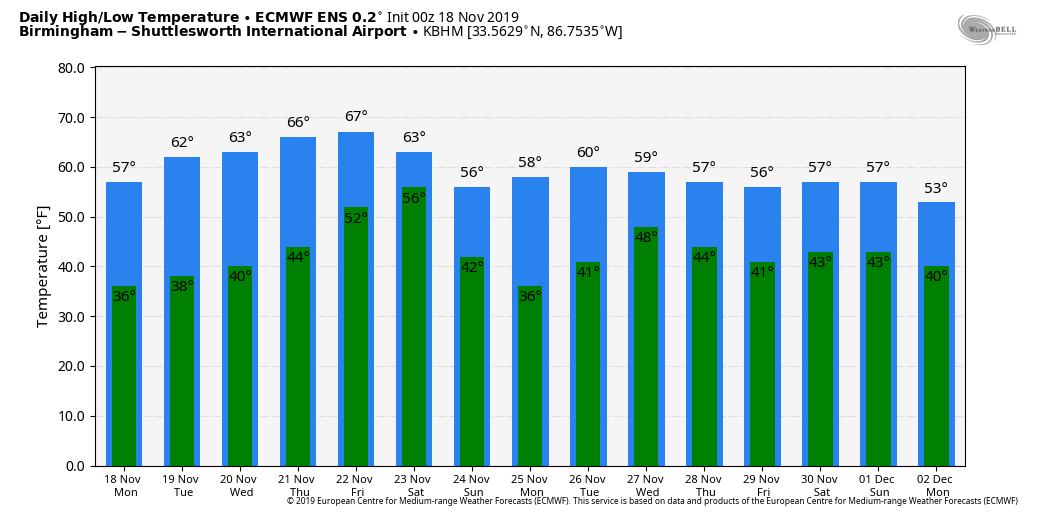
DRY THOUGH WEDNESDAY: An upper trough will bring some clouds to Alabama today, but the air looks too dry for any rain. With a mix of sun and clouds, we are forecasting a high around 60 degrees this afternoon. The average high for November 18 at Birmingham is 65.
The weather should stay rain-free through through mid-week, with mostly sunny mild afternoons and fair, chilly nights. The high tomorrow will be in the mid 60s, and we have a decent chance of reaching the low 70s Wednesday and Thursday.
RAIN RETURNS: A cold front approaching from the north will bring rain to the northern half of the state Friday afternoon and Friday night. A wave of low pressure is expected to move along the front, enhancing rain rates Friday night into early Saturday morning. For now the air looks too stable for any risk of severe thunderstorms. Rain amounts of 1-2 inches are likely for the northern counties, with 1/2 to 1 inch for South Alabama.
THE ALABAMA WEEKEND: Rain will end from west to east Saturday morning, followed by a clearing sky Saturday night. We will be able to be much more specific about exactly when the rain ends as the weekend gets closer. Saturday will be a cooler day with a high in the mid 50s. Then, on Sunday, sunshine returns in full force with a high around 60 degrees.
NEXT WEEK: The weather looks dry Monday, and most of the day Tuesday… global models suggest a storm system will bring rain back to Alabama on Wednesday (Thanksgiving Eve); thunderstorms could be involved as well. This system could impact travel across much of the Central U.S. on the biggest travel day of the year, but it is way too early to be specific. Cool, dry weather looks likely for Alabama Thanksgiving Day and Black Friday. See the Weather Xtreme video for maps, graphics, and more details.
TROPICS: A disturbance (Invest 90L) in the Atlantic, east of the Leeward Islands, has a medium chance of development over the next five days. It will move generally northward, and for now seems to be no threat to the U.S. The rest of the Atlantic is quiet… hurricane season runs through the end of this month.
ON THIS DATE IN 1957: A tornado moved through the Birmingham metro, killing one person and injuring 25. After touching down in Ensley, the tornado proceeded northeast through the Pratt area and North Birmingham and eventually into Tarrant. Many homes between 22nd and 24th streets on 35th and 36th Avenues North were damaged with numerous large trees down around the area. The Birmingham Airport reported winds of 69 mph and reported the funnel just to the northwest. Damage in Tarrant was mainly to the industrial area. November 17 and 18, 1957 were very active across the entire state of Alabama. An additional 13 tornadoes were reported statewide with several injuries and fatalities. Major damage was reported in Walker, Jefferson, Tuscaloosa, Blount and Marshall Counties.
BEACH FORECAST: Click here to see the AlabamaWx Beach Forecast Center page.
WEATHER BRAINS: Don’t forget you can listen to our weekly 90 minute show anytime on your favorite podcast app. This is the show all about weather featuring many familiar voices, including our meteorologists here at ABC 33/40.
CONNECT: You can find me on all of the major social networks…
Facebook
Twitter
Instagram
Pinterest
Snapchat: spannwx
I have a weather program this morning at Charles Brown Elementary in Birmingham… look for the next Weather Xtreme video here by 4:00 this afternoon. Enjoy the day!
Category: Alabama's Weather, ALL POSTS, Weather Xtreme Videos
About the Author (Author Profile)
James Spann is one of the most recognized and trusted television meteorologists in the industry. He holds the AMS CCM designation and television seals from the AMS and NWA. He is a past winner of the Broadcast Meteorologist of the Year from both professional organizations.Subscribe
If you enjoyed this article, subscribe to receive more just like it.


