Sunny Today; Rain Returns Tomorrow Night
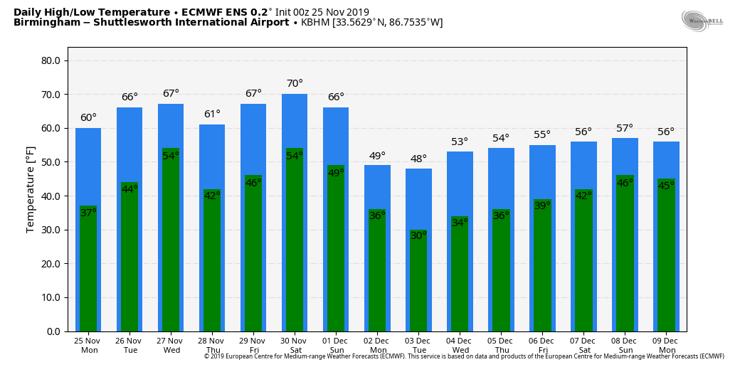
COLD START: Temperatures are in the 28-34 degree range over most of North/Central Alabama early this morning… and we have upper 30s as far south as Mobile. Today will feature sunshine in full supply with a high around 60 degrees.
RAIN RETURNS: Clouds return to the state tomorrow, and a few periods of rain are likely late tomorrow night into Wednesday morning. For now it looks like the main window for rain comes from 12:00 midnight tomorrow night through 12:00 noon Wednesday. Rain amounts of around 1/2 inch are likely, and while some thunder is possible, there is no significant threat of severe storms due to the lack of surface based instability. The high tomorrow will be in the mid 60s… then on Wednesday after starting the day in the 60s, temperatures will likely fall into the 50s by afternoon following the surface cold front.
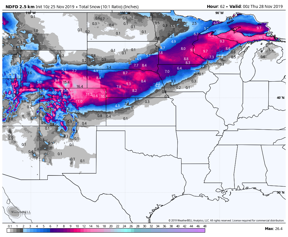
TRAVELERS BEWARE: The same system that will bring rain to Alabama will bring lots of snow in a broad band from Denver to the Upper Peninsula of Michigan; winter storm watches and warnings are in effect there.
THANKSGIVING DAY/BLACK FRIDAY: Thursday will be cool and dry with ample sunshine; we start the day between 35 and 40; the high will be close to 60 degrees. Friday will be partly sunny with a high in the mid 50s.
THE ALABAMA WEEKEND: The next storm system will bring rain to Alabama over the weekend. The sky becomes cloudy Saturday, and rain and thunderstorms are likely Saturday night into Sunday morning. For now, it looks like the best chance of rain will come from 6:00 p.m. Saturday through 9:00 a.m. Sunday, but keep in mind that could change as we get closer to the weekend. Rain amounts of 1/2 to 1 inch are likely, and a few strong storms can’t be ruled out. For now, however, instability values look too low for a major severe weather threat. Saturday will be mild with a high around 70 degrees, but colder air rolls in Sunday with temperatures in the 50s most of the day.
NEXT WEEK: Dry, cool weather is the story for Monday and Tuesday; the next weather system will bring the next chance of rain by Wednesday and Wednesday night. See the Weather Xtreme video for maps, graphics, and more details.
TROPICS: The Atlantic basin is now quiet, and most likely the next tropical storm or hurricane will come in the summer of 2020. The season ends Saturday.
IRON BOWL: For the biggest game of the year in Alabama (2:30p CT kickoff Saturday at Jordan-Hare Stadium), the sky will be mostly cloudy with a kickoff temperature near 70 degrees. For now, we believe the rain arrives after the game is over, generally after 7 p.m. But, of course, the game is still five days away and things could change. We will keep you posted.
ON THIS DATE IN 1950: Called the “storm of the century” at the time, this storm impacted the eastern part of the U.S., killing hundreds and causing millions of dollars in damages. New York City recorded a 94 mph wind gust and Bear Mountain, just north of the city recorded a 140 mph gust. Record low temperatures were reported on the southern end of this storm in Tennessee and North Carolina. This storm was unique as Pittsburgh saw 30 inches of snow, while Buffalo saw 50 degrees with 50 mph wind gusts. The official low in Birmingham November 25, 1950 was 5 degrees, the coldest November temperature on record.
ON THIS DATE IN 1986: An F3 tornado with a path of 44 miles moved through parts of Coffee, Dale and Barbour Counties in Southeast Alabama. The twister developed in the New Brockton area and had an intermittent path to the northeast down Ariton, Elamville, Clio and then Clayton where the tornado dissipated. There were 3 injuries in New Brockton and 1 church, 3 homes and 2 other buildings were destroyed. Near Ariton, an injury occurred in a mobile home. A total of 2 mobile homes were destroyed. Four homes, a business building, 6 mobile homes and several outbuildings were destroyed near Elamville.
BEACH FORECAST: Click here to see the AlabamaWx Beach Forecast Center page.
WEATHER BRAINS: Don’t forget you can listen to our weekly 90 minute show anytime on your favorite podcast app. This is the show all about weather featuring many familiar voices, including our meteorologists here at ABC 33/40.
CONNECT: You can find me on all of the major social networks…
Facebook
Twitter
Instagram
Pinterest
Snapchat: spannwx
Look for the next Weather Xtreme video here by 4:00 this afternoon… enjoy the day!
Category: Alabama's Weather, ALL POSTS, Weather Xtreme Videos
About the Author (Author Profile)
James Spann is one of the most recognized and trusted television meteorologists in the industry. He holds the AMS CCM designation and television seals from the AMS and NWA. He is a past winner of the Broadcast Meteorologist of the Year from both professional organizations.Subscribe
If you enjoyed this article, subscribe to receive more just like it.


