Potential For Strong To Severe Storms Tonight Through The Overnight Hours
Sorry for the lateness of the post. I had a few technical difficulties this morning with my equipment. All is well now.
IRON BOWL SATURDAY
Rain looks to continue to hold off for much of the day across Central Alabama which will be great news for the big game down on the plains in Auburn. Skies will be mostly clear to start but clouds will be increasing throughout the day. Afternoon highs will top out in the mid-60s to the mid-70s across the area. A stray shower or two may be possible in the northwestern parts of the area, but it will stay dry on the plains. Kickoff temperature at 2:30 pm will be around 72 degrees and will fall into the 60s throughout the game.
TONIGHT THROUGH SUNDAY
A strong cold front will be approaching Central Alabama today, but warm air advection out ahead of that is expected to destabilize the atmosphere enough for strong to severe storms to affect the area with damaging winds and a few brief tornadoes possible for tonight through the overnight hours.
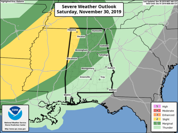
The Storm Prediction Center has a Slight Risk for severe storms for the extreme west and northwestern parts of the area mainly for tonight through early Sunday morning, while a marginal risk is up for a good portion of the rest of Central Alabama.
NWS Birmingham has a Marginal Risk is up for much of Central Alabama mainly from 7:00 pm tonight through 7:00 am Sunday morning. Damaging winds up to 60 MPH and a few brief tornadoes are possible. To break that down even further:
Locations west of a line from Holly Pond to Tuscaloosa to Forkland could see strong to severe storms from 7:00 pm to midnight. East of that to a line stretching from Ranburne to Alexander City to Montgomery will be from 10:00 pm to 3:00 am. Locations east of that will be from 1:00 am to 7:00 am.
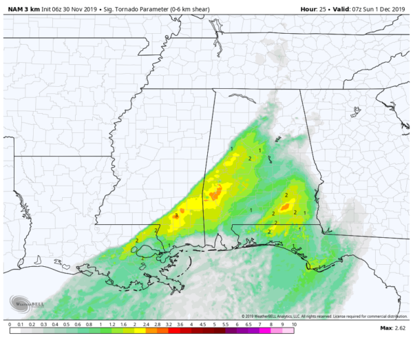
STP values valid at 1:00 am Sunday from the 06z high-resolution NAM.
While we will have plenty of wind shear and helicity in place across the entire area, but the better amounts of surface-based instability will remain over the southern two-thirds of the area. Dewpoints will be well up in the 60s throughout the night ahead of the front. That means that the higher probabilities of brief spin-up tornadoes will be south of the I-20 corridor. The latest Significant Tornado Parameters off of the high-res NAM shows values of up to 2.4 over parts of the area, while values drop off drastically as you move north of I-20.
Be sure to have multiple ways to receive warnings tonight through the overnight hours, especially one that will wake you up in case a warning is issued for your location while you are asleep. Go ahead and have those safety kits and place of safety ready. Keep those batteries charged in those smartphones and have fresh ones in your flashlights and in your NOAA WeatherRadio.
Much, if not all of the activity, should be out of Central Alabama by mid-morning on Sunday, and the rest of the day will be dry with skies becoming mainly sunny by the afternoon. Highs will be in the upper 50s to the upper 60s. Winds will be gusty at times but should stay below Wind Advisory criteria. Much cooler air will move into Central Alabama during the overnight hours.
MONDAY THROUGH WEDNESDAY
Monday will be a much cooler day with plenty of sunshine for the southern half of the area while it will be partly to mostly cloudy for the northern half. Highs will be in the mid-40s to the lower 50s.
Tuesday will have mostly clear skies throughout the area and temperatures will be a touch warmer. Highs top out in the upper 40s to the mid-50s.
Wednesday will pretty much be the same story… Plenty of sunshine and a little warmer. Highs will reach the mid-50s to the lower 60s.
THURSDAY & FRIDAY
On Thursday, we’ll have a low moving rapidly across the southeast which looks to bring a chance of showers into the forecast for late Thursday through the daylight hours on Friday, but the rain exits by the evening and skies will begin to slowly clear out. Highs will be in the upper 50s to the mid-60s on both days.
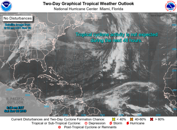
TROPICAL UPDATE
Today is the final day of the 2019 Atlantic Hurricane Season and it looks like we should close out the season on a quiet note. All is quiet across the Atlantic Basin and no new tropical cyclones are expected to develop over the next five days. The next scheduled tropical update will be on June 1st, 2020.
Category: Alabama's Weather, ALL POSTS, Severe Weather, Weather Xtreme Videos
About the Author (Author Profile)
Scott Martin is an operational meteorologist, professional graphic artist, musician, husband, and father. Not only is Scott a member of the National Weather Association, but he is also the Central Alabama Chapter of the NWA president. Scott is also the co-founder of Racecast Weather, which provides forecasts for many racing series across the USA. He also supplies forecasts for the BassMaster Elite Series events including the BassMaster Classic.Subscribe
If you enjoyed this article, subscribe to receive more just like it.


