Windy, Much Colder Today
BLUSTERY MONDAY: A deep upper low is moving through the eastern third of the nation this morning, and will pull much colder air down into Alabama today. We note a few snow flurries on radar over the northeast counties of the state early this morning, but temperatures are above freezing, and there will be no impact. Look for a mix of sun and clouds today; temperatures won’t get out of the 40s, and they hold in the 30s all day over the Tennessee Valley of far North Alabama. A brisk northwest wind of 10-20 mph will make it feel colder.
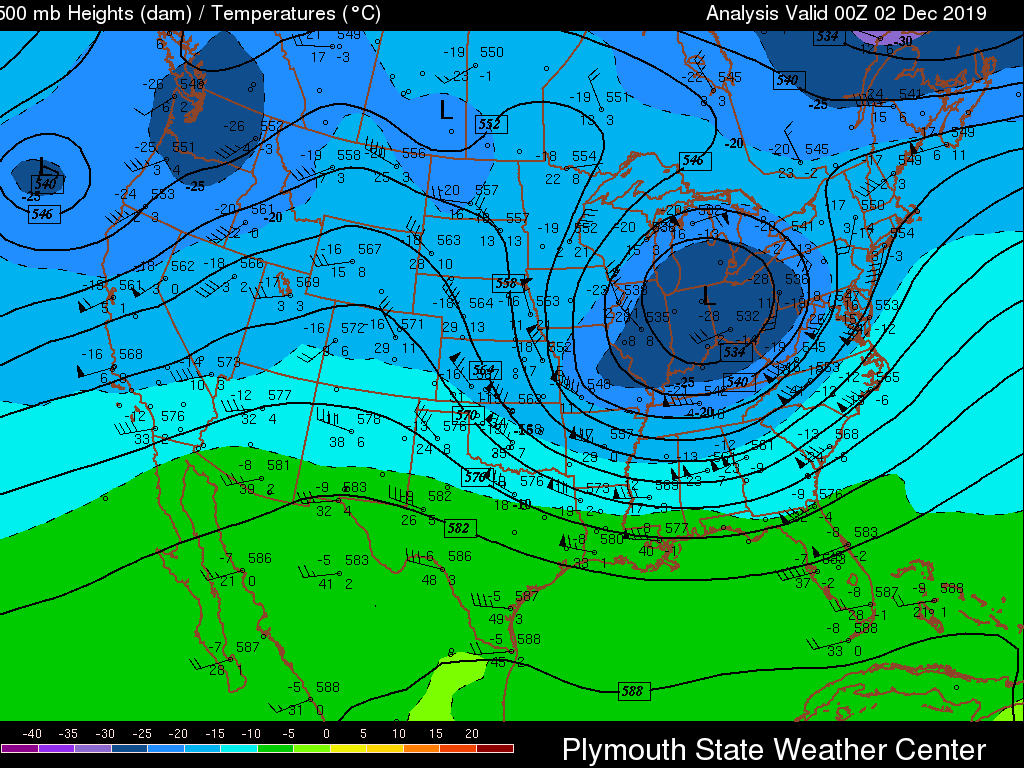
The wind will die down tonight, and with a clear sky temperatures will drop into the 24-49 degree range early tomorrow morning across North/Central Alabama.
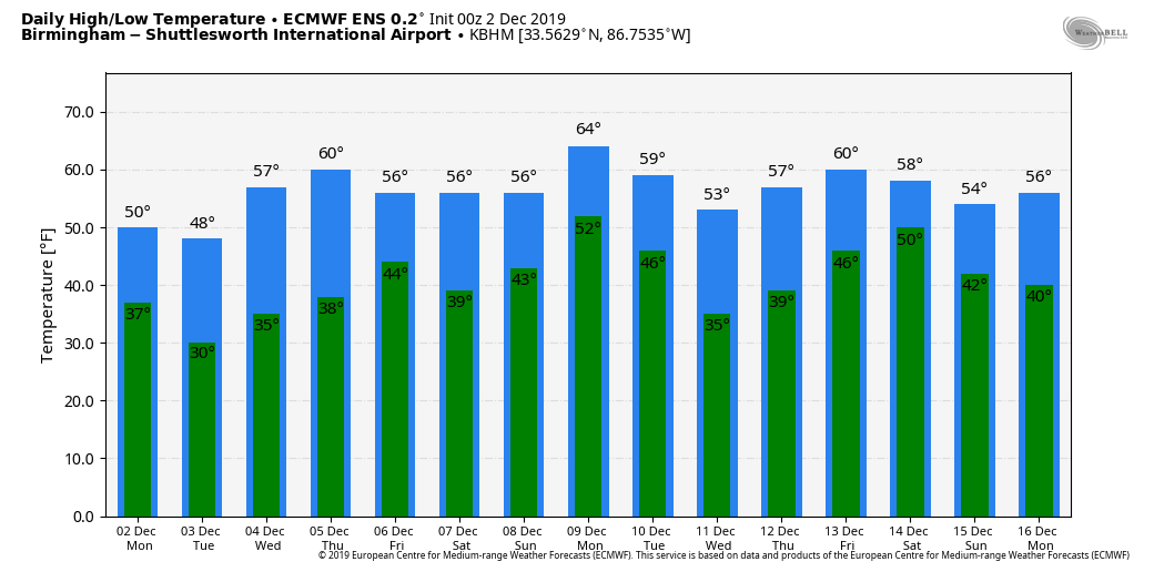
REST OF THE WEEK: Look for sunny days, and fair nights tomorrow through Thursday with a warming trend. The high tomorrow will be near 50 degrees, and close to 60 by Wednesday. Thursday’s high will be in the low 60s. Clouds will increase Thursday night, and a wave will bring a chance of rain at times Friday. For now it doesn’t look like a big rain event; amounts should be 1/2 inch or less for most places. And, the air will be stable so we probably won’t have any thunder. The high Friday will be in the 50s.
THE ALABAMA WEEKEND: Saturday will be a dry day with a partly sunny sky; the high will be close to 60. Moisture levels rise Sunday, and for now it looks like the best chance of rain will be over Far East and Southeast Alabama. The high Sunday will be in the low 60s.
NEXT WEEK: A cold front will bring periods of rain to the state Monday and Tuesday, followed by another surge of colder, drier air for the latter half of the week. See the Weather Xtreme video for maps, graphics, and more details.
WELCOME TO DECEMBER: It is a time of the year when you can have a very wide range of weather conditions in Alabama. We almost always have warm spells; since 1900, December temperatures have exceeded 75 degrees in 27 of those 119 years. Our warmest December day came on December 7, 1951, when the high in Birmingham was 80 degrees. The high in Birmingham Christmas Eve, 1964, was 77 degrees. Kids were playing in shorts the following Christmas morning; the high that day was 72. On the other hand, the coldest December temperature on record at Birmingham is 1 degree, recorded on December 13, 1962 and December 23, 1989. And, don’t forget severe storms and tornadoes are possible this month as well… part of our November/December “second” season in Alabama.
ON THIS DATE IN 1959: Between November 19 and December 2, an estimated 20 inches of rain fell near the town of Frejus on the French Riviera. This rain caused the Malpasset Dam to collapse which sent a 130-foot high wall of water into the towns of Malpasset and Bozon. The wall of water 10 feet tall reached Frejus, flooding the western half of the city. The dam breach killed 423 people and caused $68 million in damages.
BEACH FORECAST: Click here to see the AlabamaWx Beach Forecast Center page.
WEATHER BRAINS: Don’t forget you can listen to our weekly 90 minute show anytime on your favorite podcast app. This is the show all about weather featuring many familiar voices, including our meteorologists here at ABC 33/40.
CONNECT: You can find me on all of the major social networks…
Facebook
Twitter
Instagram
Pinterest
Snapchat: spannwx
I have a weather program this morning at the Gardendale Civic Center…. look for the next Weather Xtreme video here by 4:00 this afternoon. Enjoy the day!
Category: Alabama's Weather, ALL POSTS, Weather Xtreme Videos
About the Author (Author Profile)
James Spann is one of the most recognized and trusted television meteorologists in the industry. He holds the AMS CCM designation and television seals from the AMS and NWA. He is a past winner of the Broadcast Meteorologist of the Year from both professional organizations.Subscribe
If you enjoyed this article, subscribe to receive more just like it.


