

Rain & Storms Moving In From The West At 10:15 AM; Not Expecting Severe Weather
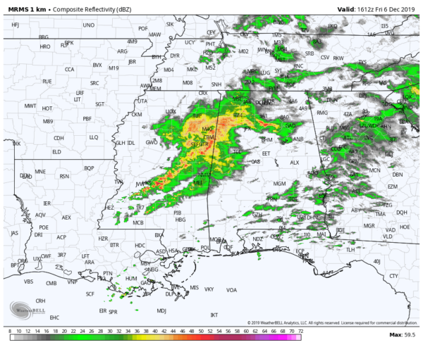
A line of heavier rain and thunderstorms is in the process of pushing across the Alabama/Mississippi state line as of 10:15 am, and one of the cells within the line is trying to misbehave at the moment.
A Significant Weather Advisory continues in effect for portions of Lamar and Pickens counties until 10:45 am for the threat of wind gusts of up to 40 MPH and the potential for pea-size hail. That storm was moving east at 35 MPH.
There is a decent amount of lightning occurring along the line that stretches from roughly Hamilton back to the south-southwest through Suligent, Vernon, across the state line into Columbus, and Macon, before hooking back more southwestward into Philadelphia.
No lightning is occurring at this time with the rain that is moving over the extreme northern parts of Central Alabama and up into North Alabama, but some heavier rain is falling around the Cullman and Hanceville areas.
While we are not expecting any severe storms with this system moving through Central Alabama, a few thunderstorms can be expected which could have the potential for gusty winds up to 40 MPH and small hail.
Category: Alabama's Weather, ALL POSTS
About the Author (Author Profile)
Scott Martin is an operational meteorologist, professional graphic artist, musician, husband, and father. Not only is Scott a member of the National Weather Association, but he is also the Central Alabama Chapter of the NWA president. Scott is also the co-founder of Racecast Weather, which provides forecasts for many racing series across the USA. He also supplies forecasts for the BassMaster Elite Series events including the BassMaster Classic.Subscribe
If you enjoyed this article, subscribe to receive more just like it.


