Some Rain At Times Today; Strong/Severe Storms Monday
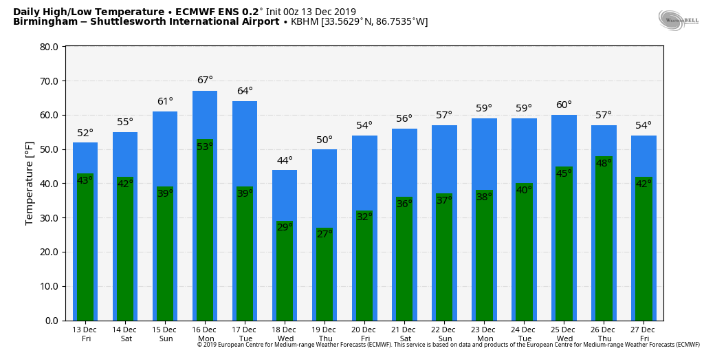
CLOUDY, DAMP WEATHER: Today will be a cloudy, cool day across Alabama with periods of mostly light rain as a wave of low pressure passes through. The most widespread rain will come over the eastern and southern counties of the state, and even there amounts should be around 1/2 inch or less for most places. Temperatures will hold in the 40s over North Alabama today, with 50s and low 60s for South Alabama. No risk of severe storms, and probably very little thunder. Rain will taper off tonight.
THE ALABAMA WEEKEND: Clouds will linger tomorrow morning, and we will mention the risk of a few showers over the northern third of the state as the upper trough passes through. Some sun could break through tomorrow afternoon thanks to subsidence on the back side of the departing trough; the high tomorrow will be in the 55-60 degree range for most communities. Then, on Sunday, the sky will be partly sunny with a high in the 60s.
STORMY MONDAY: The next weather system will bring rain back to Alabama Monday afternoon into Monday night, along with the threat of strong thunderstorms. SPC has a decent part of the state in a severe weather risk area Monday on their “Day 4” convective outlook..
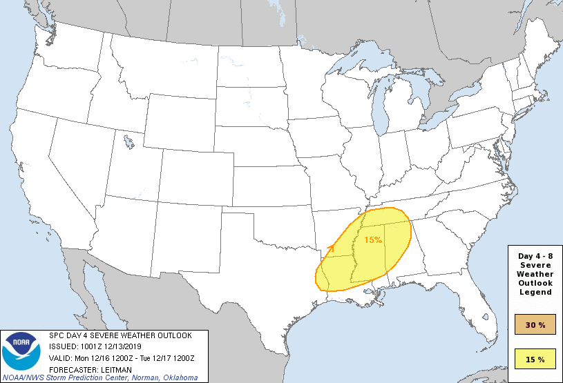
Temperatures will likely reach the low 70s Monday afternoon, along with dew points near 60, making for an unstable airmass. For now it looks like the main window for severe storms will come from about 3:00 p.m. until 12:00 midnight, with the higher risk levels over the northern and west part of the state. Heavier storms could produce strong, possibly damaging winds, hail, and even a few tornadoes. We will be much more specific about the threat over the weekend as we get closer to the event.
Rain ends after midnight Monday night, and Tuesday will be a much colder day with lingering clouds; temperatures hold in the 40s most of the day. Then, we will be dry Wednesday and Thursday with sunny cool days and clear cold nights. Morning lows will be well down in the 20s; the high Wednesday will be in the mid to upper 40s, followed by low 50s Thursday. Clouds will increase Friday, and rain returns to the state by Friday night and Saturday (December 21)… See the Weather Xtreme video for maps, graphics, and more details.
ON THIS DATE IN 1997: A freak cold snap and snowstorm struck parts of northern Mexico left 12 people dead, and the area paralyzed. It snowed in the city of Guadalajara for the first time since 1881, leaving amazed residents to gawk at the white stuff and make snowmen. The temperature plunged to 5 degrees in Chihuahua.
BEACH FORECAST: Click here to see the AlabamaWx Beach Forecast Center page.
WEATHER BRAINS: Don’t forget you can listen to our weekly 90 minute show anytime on your favorite podcast app. This is the show all about weather featuring many familiar voices, including our meteorologists here at ABC 33/40.
CONNECT: You can find me on all of the major social networks…
Facebook
Twitter
Instagram
Pinterest
Snapchat: spannwx
I have a weather program this morning at Addison Elementary in Winston County… look for the next Weather Xtreme video here by 4:00 this afternoon. Enjoy the day!
Category: Alabama's Weather, ALL POSTS, Weather Xtreme Videos
About the Author (Author Profile)
James Spann is one of the most recognized and trusted television meteorologists in the industry. He holds the AMS CCM designation and television seals from the AMS and NWA. He is a past winner of the Broadcast Meteorologist of the Year from both professional organizations.Subscribe
If you enjoyed this article, subscribe to receive more just like it.


