Severe Storms Threaten Alabama Tonight
**No afternoon Weather Xtreme today today**
ACTIVE NIGHT AHEAD: A dynamic weather system will push strong to severe thunderstorms through Alabama tonight. SPC maintains an “enhanced risk” (level 3/5) of severe storms for West Alabama… places like Tuscaloosa, Reform, Eutaw, York, Livingston, and Butler. A “slight risk” (level 2/5) covers the rest of the state.
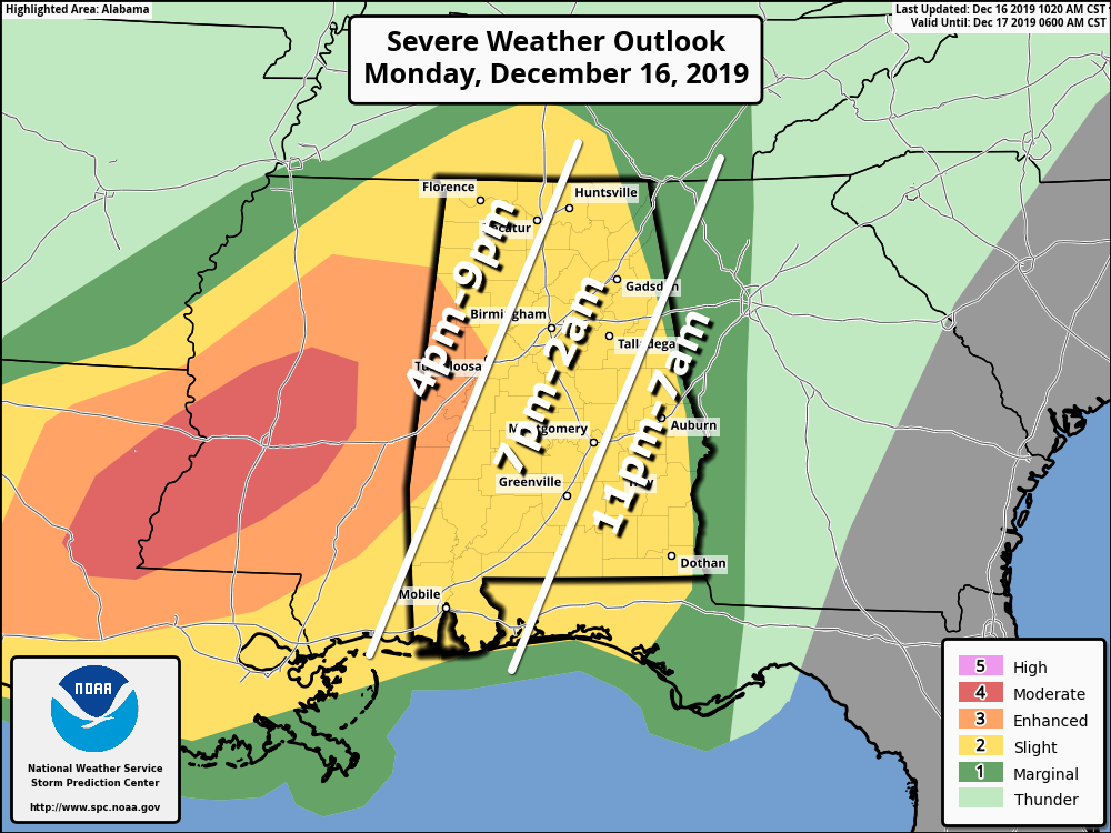
To the west, there have been multiple tornadoes today across Louisiana today with some significant damage. Temperatures are now in the 70s over much of Alabama this afternoon, making for a rather unstable atmosphere. A tornado watch in effect for East Mississippi until 9p CT… watches will be required for much of Alabama tonight.
THREATS: Storms across Alabama tonight are capable off producing large hail, damaging winds, and a few tornadoes. A few strong tornadoes (EF-3 or higher) are possible over West Alabama, especially in the enhanced risk area.
TIMING: Storms could move into West Alabama as early as 5:00, but most of the action comes after dark into the overnight hours. A few strong storms could linger as late as 7:00 a.m. over Southeast Alabama.
RAIN: Rain amounts of 1 inch are likely, isolated amounts to two inches are possible. No major flooding issues are expected.
CALL TO ACTION: We haven’t had a severe weather threat here in a while, so be sure you and your family are ready…
*Be sure you have a properly programmed NOAA Weather Radio in your home and business, WEA alerts enabled on your phone, and the ABC 33/40 Weather app installed.
*In your safe place, have helmets, portable air horns, and hard sole shoes for everyone in your family.
*If you live in a mobile home, you can’t be there during a tornado warning polygon. Think about what you will do, and where you will go tonight if severe weather approaches. Know the closest community shelters, or businesses that are open 24/7 that can provide protection. Know the quickest way to get there.
*If we do have tornado warnings, remember my core attention will be focused on the TV and video coverage. You can watch ABC 33/40 on the mobile apps, the web, and Facebook live tonight.
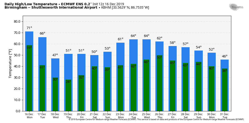
TOMORROW: Rain ends very early in the day; it will be windy and sharply colder with temperatures falling into the 40s along with a brisk northwest wind of 12-22 mph. Clouds linger much of the day, but we could see some clearing by mid to late afternoon. Temperatures drop off quickly tomorrow night, and we will be in the 20s by daybreak Wednesday.
REST OF THE WEEK: The weather looks dry Wednesday through Friday with cool days and cold nights; we drop into the 20s again early Thursday. Afternoon high will be generally in the 50s.
THE ALABAMA WEEKEND: New model data suggests a surface low will move out of the Gulf of Mexico, bringing rain back into Alabama late Friday night, and during much of the day Saturday. This is supported by both the American GFS and the European ECMWF; the rain should end early Sunday, followed by clearing Sunday afternoon. Highs over the weekend will remain in the 50s.
CHRISTMAS WEEK: The pattern favors dry weather for most of next week with above average temperatures; it looks like we will enjoy highs generally in the 60s. No white Christmas around here for sure.
ON THIS DATE IN 2000: An EF-4 tornado tore through the southern part of Tuscaloosa, killing eleven people and injuring over 100. Nine of the fatalities occurred in mobile homes, one in a vehicle, and one in a commercial building converted to residential use. Six of those killed were females and five were males. Ages ranged from 16 months to 83 years old. The tornado was on the ground for a total of 18 miles, all within Tuscaloosa county. The tornado path was estimated to be 750 yards wide at it’s maximum intensity.
There was an excellent warning for the tornado; a warning was issued at 12:40 p.m. on that deadly Saturday, 14 minutes before the twister first touched down in a rural area southwest of Tuscaloosa near the Black Warrior River. The tornado crossed Alabama 69 near Shelton State Community College and Hillcrest High School; destroying a shopping center and many homes. The Bear Creek Trailer Park was hit, where many of the deaths occurred. The tornado moved to the east/northeast, south of Skyland Boulevard, and finally crossed I-59/20 near the Cottondale exit.
Later in the day, the same parent storm dropped an EF-3 tornado which stuck the Coats Bend region of Etowah County, near Gadsden, destroying 250 homes and injuring 14 people. Like the Tuscaloosa tornado, excellent warnings were issued by the National Weather Service long before the damage occurred. Just another reminder we can have some very violent weather this time of the year; the core of our late fall/early winter tornado season.
BEACH FORECAST: Click here to see the AlabamaWx Beach Forecast Center page.
WEATHER BRAINS: Don’t forget you can listen to our weekly 90 minute show anytime on your favorite podcast app. This is the show all about weather featuring many familiar voices, including our meteorologists here at ABC 33/40.
CONNECT: You can find me on all of the major social networks…
Facebook
Twitter
Instagram
Pinterest
Snapchat: spannwx
Keep an eye on ABC 33/40 and the blog for frequent updates tonight…
Category: Alabama's Weather, ALL POSTS
About the Author (Author Profile)
James Spann is one of the most recognized and trusted television meteorologists in the industry. He holds the AMS CCM designation and television seals from the AMS and NWA. He is a past winner of the Broadcast Meteorologist of the Year from both professional organizations.Subscribe
If you enjoyed this article, subscribe to receive more just like it.


