Much Colder Today; Rain Moves Out Early
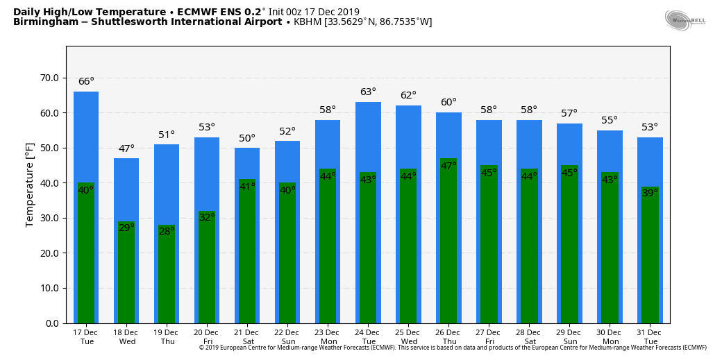
WINDY, COLDER: Rain is still falling early this morning over East and South Alabama; that rain ends by mid-morning, and today will be cloudy, breezy, and much colder with temperatures holding in the 40s all day over the northern half of the state. The sky will clear tonight, and most places across North/Central Alabama will drop into the 20s early tomorrow morning.
REST OF THE WEEK: The weather looks dry tomorrow through Friday with cool days and chilly nights. Highs will be in the 50s; morning lows will be in the 20s early Thursday, and close to freezing Friday morning. Lots of sunshine tomorrow and Thursday; then a partly sunny sky Friday.
THE ALABAMA WEEKEND: A surface low moving along the Gulf Coast will bring rain back to Alabama over the weekend. Global models are not in very good agreement, so the timing of the rain is a low confidence forecast. For now, we will bring in a chance of rain Saturday, Saturday night, into at least part of the day Sunday. It certainly won’t rain all weekend, but expect periods of rain with highs in the 50s. No risk of severe storms, and probably not much thunder. Heavier rain amounts should be over South Alabama, where over one inch is possible. Totals over the northern half of the state, most likely, will be under one inch.
CHRISTMAS WEEK: For now the weather looks dry all week, and very comfortable with highs in the 60s, almost ten degrees above average for late December in Alabama. See the Weather Xtreme video for maps, graphics, and more details.
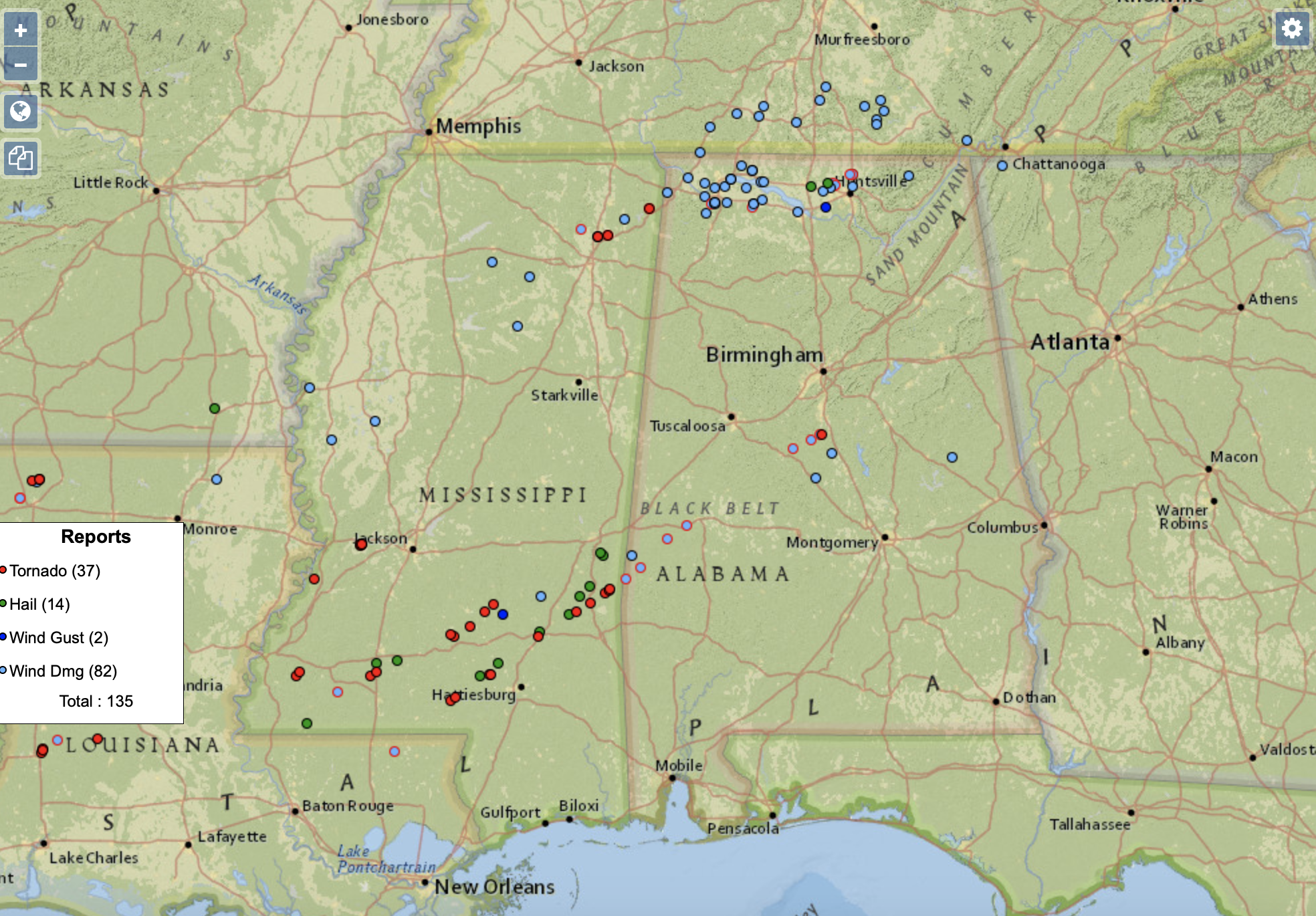
MONDAY’S STORMS: Two people were killed in North Alabama due to a tornado in North Lawrence County late yesterday. The fatalities, identified by officials as husband and wife, were on the north side of County Road 265 near Town Creek. Four others on the road were critically injured, including a 7-year-old child who is being transported to Children’s Hospital in Birmingham.
Significant tornado damage was also reported last night from a long track supercell storm just west of Demopolis, and near Montevallo and Ashby in parts of Bibb and Shelby County. No injuries to our knowledge in those places.
ON THIS DATE IN 1924: From the Monthly Weather Review, “a severe glaze storm occurred in west-central Illinois on December 17 and 18, the area of great destruction embracing a territory about 75 miles in width and 170 miles in length. In the affected area, trees were badly damaged, wires broken, and thousands of electric poles went down. Electric services were paralyzed, and it required weeks to restore operation and months to permanently rebuild the lines.
BEACH FORECAST: Click here to see the AlabamaWx Beach Forecast Center page.
WEATHER BRAINS: Don’t forget you can listen to our weekly 90 minute show anytime on your favorite podcast app. This is the show all about weather featuring many familiar voices, including our meteorologists here at ABC 33/40.
CONNECT: You can find me on all of the major social networks…
Facebook
Twitter
Instagram
Pinterest
Snapchat: spannwx
I have a weather program this mooring at the Cherokee County Career and Technology Center in Centre… look for the next Weather Xtreme video here by 4:00 this afternoon. Enjoy the day!
Category: Alabama's Weather, ALL POSTS, Weather Xtreme Videos
About the Author (Author Profile)
James Spann is one of the most recognized and trusted television meteorologists in the industry. He holds the AMS CCM designation and television seals from the AMS and NWA. He is a past winner of the Broadcast Meteorologist of the Year from both professional organizations.Subscribe
If you enjoyed this article, subscribe to receive more just like it.


