Latest Mesoscale Discussion Is Out From SPC… Severe Threat Continues
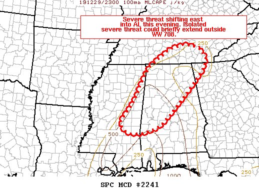
The threat of severe storms continues across the northwestern and western parts of North/Central Alabama. Several embedded cells over the past hour or so have shown sporadic rotation at times and has caused a few tornado warnings to be issued. Environmental Conditions outlined in the mesoscale discussion continue to be supportive of strong to severe thunderstorms. Here is the text from the SPC:
The severe weather threat for Tornado Watch 708 continues.
SUMMARY…Severe threat continues across extreme eastern MS into
parts of western AL. A new watch or local extensions may be needed
for portions of the region this evening.
DISCUSSION…A broken line of storms extends from far northwest AL
south/southwest along the MS/AL border as of 2345z this evening. A
bowing segment at the north end of the line could be producing
damaging gusts as it tracks northeast toward southern middle TN over
the next hour. Further south, several embedded cells have shows
sporadic moderate low level rotation in the vicinity of Kemper and
Noxubee counties in MS. Objective analysis indicates MLCAPE values
between 250-500 J/kg are in place ahead of the line across
northern/central AL and spread northward into parts of
south-central/southeast TN and northwest GA. Regional VWPs continue
to show low level hodographs favorable for rotation, and damaging
gusts and a couple of tornadoes remain possible.
With storms tracking to the northeast at around 35-50 kt, the line
should approach the northern edge of WW 708 in the next hour near
the AL/TN border, and in the next 1-2 hours further east across
central AL. It is unclear how far north and east the severe threat
may continue given quickly diminishing instability and increasing
inhibition with loss of daytime heating. Nevertheless, given
strength of vertical shear and rather rich boundary layer dewpoints,
storms could continue to pose a threat at least briefly across parts
of southern middle/southeast TN into far northwest GA and portions
of central/northeastern AL. As such, WW 708 may need to be locally
extended, or a new downstream watch may be needed depending on
convective trends.
Category: Alabama's Weather, ALL POSTS, Severe Weather
About the Author (Author Profile)
Scott Martin is an operational meteorologist, professional graphic artist, musician, husband, and father. Not only is Scott a member of the National Weather Association, but he is also the Central Alabama Chapter of the NWA president. Scott is also the co-founder of Racecast Weather, which provides forecasts for many racing series across the USA. He also supplies forecasts for the BassMaster Elite Series events including the BassMaster Classic.Subscribe
If you enjoyed this article, subscribe to receive more just like it.


