

Widespread, Soaking Rains For Alabama
WET IS THE WORD: As a storm system slowly approaches Alabama, we expect a widespread, soaking rain event for the state over the next 36 hours. The heaviest rain is expected along and north of I-59, where a flood watch remains in effect (north of a line from Livingston to Tuscaloosa to Birmingham to Gadsden to Weiss Lake).
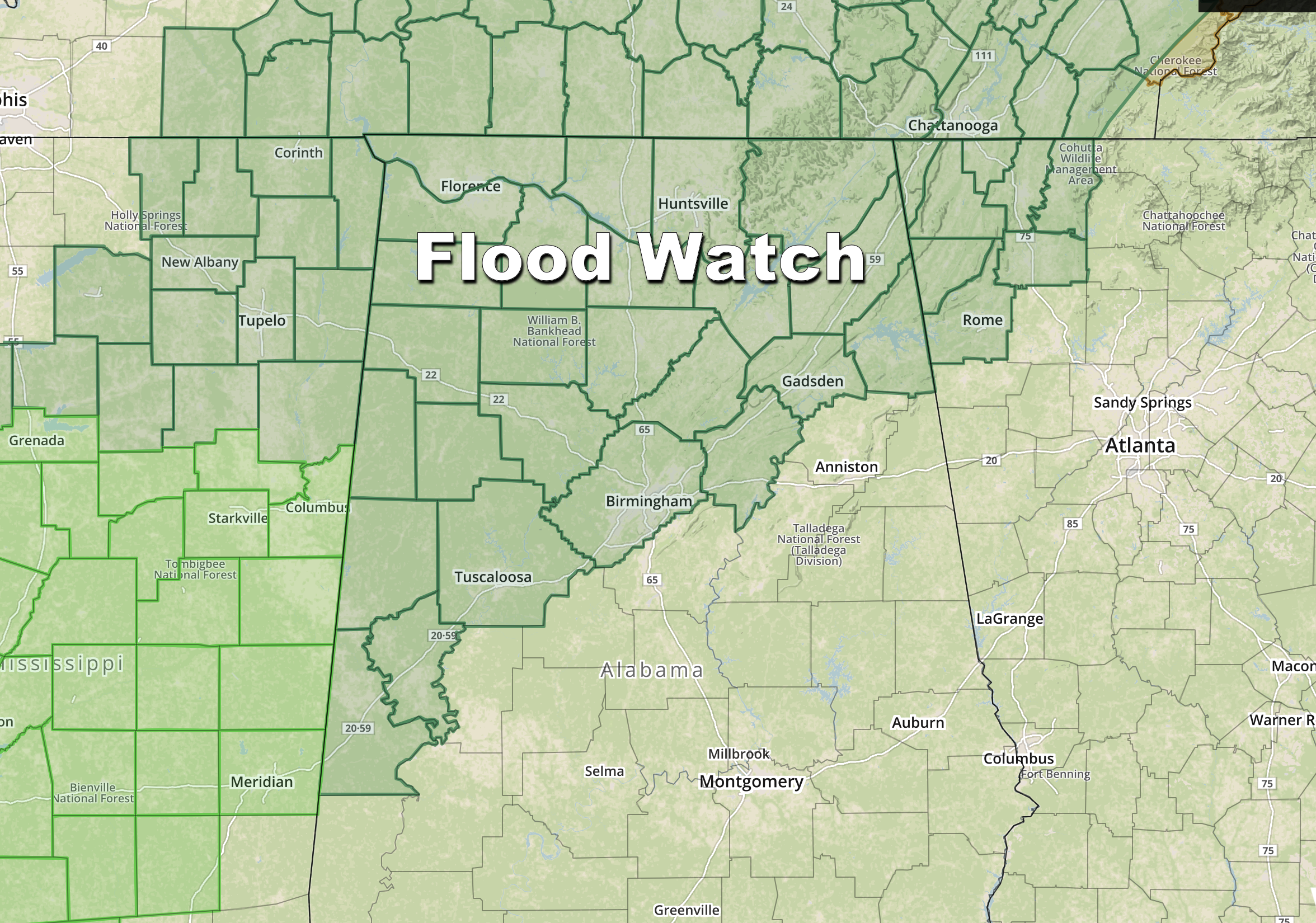
Rain amounts of 2-4 inches are likely in the flood watch area, with 1-2 inches for the southern half of the state through tomorrow night. WPC has a “moderate risk” of excessive rain defined for Northwest Alabama through tonight, when the heaviest rain is expected to fall. Periods of rain are still likely tomorrow, but the rain should be lighter.
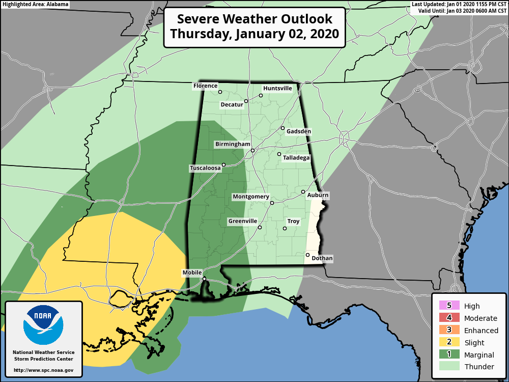
We also note SPC has a “marginal risk” (level 1/5) of severe storms defined for parts of West and Southwest Alabama later today and tonight… but instability values will not be especially high, and the higher severe weather probabilities are over South Mississippi and Southeast Louisiana.
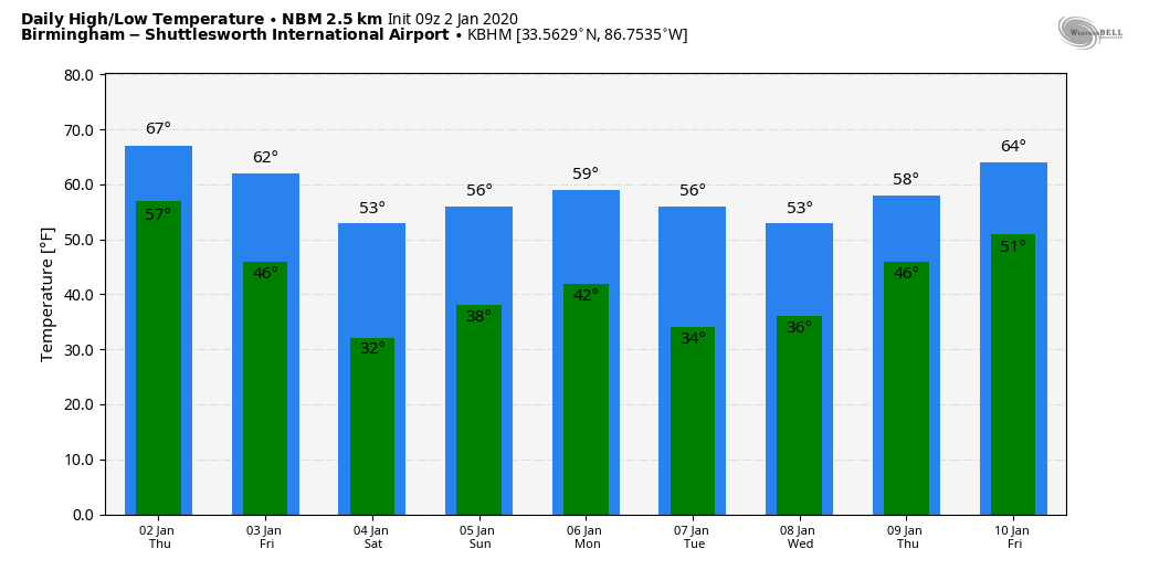
Afternoon highs today and tomorrow will be in the 58-62 degree range for North Alabama, with low 70s possible for far South Alabama.
THE ALABAMA WEEKEND: A deep upper trough will pass over the state Saturday; models have trended a little more to the north with the core of the upper low, but still it will like a mostly cloudy and colder day for the state with highs between 48 and 54. Some lingering light rain is possible Saturday morning; a few snowflakes are possible over Tennessee and Kentucky under the cold core upper low, but no impact is expected there. Sunday will be a much brighter day with sunshine back in full force. We start the day in the 28-32 degree range; the high Sunday will be in the mid 50s.
NEXT WEEK: The next wave will bring a chance of rain (mostly light) to Alabama Monday night into Tuesday, followed by another chance of rain at the end of the week on Friday (Jan 10). Temperatures for the week look seasonal with highs generally in the 50s. See the Weather Xtreme video for maps, graphics, and more details.
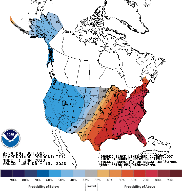
No sign of any extremely cold air for Alabama or the Southeast U.S. through mid-month; the CPC outlook for January 9-15 shows suggests above average temperatures for the eastern half of the nation.
FOOTBALL WEATHER: For the Birmingham Bowl today (Cincinnati vs Boston College; 2p CT kickoff), the sky will be cloudy with rain likely throughout the game. Some thunder is possible, but not especially likely. Temperatures will hover in the 58-62 degree range.
ON THIS DATE IN 1955: Hurricane Alice passed through the Islands of Saint Martin and Saba in the Caribbean Sea on this day. Alice, which developed on December 30, 1954, is the only known Atlantic hurricane to span two calendar years.
BEACH FORECAST: Click here to see the AlabamaWx Beach Forecast Center page.
WEATHER BRAINS: Don’t forget you can listen to our weekly 90 minute show anytime on your favorite podcast app. This is the show all about weather featuring many familiar voices, including our meteorologists here at ABC 33/40.
CONNECT: You can find me on all of the major social networks…
Facebook
Twitter
Instagram
Pinterest
Snapchat: spannwx
Look for the next Weather Xtreme video here by 4:00 this afternoon… enjoy the day!
Category: Alabama's Weather, ALL POSTS, Weather Xtreme Videos
About the Author (Author Profile)
James Spann is one of the most recognized and trusted television meteorologists in the industry. He holds the AMS CCM designation and television seals from the AMS and NWA. He is a past winner of the Broadcast Meteorologist of the Year from both professional organizations.Subscribe
If you enjoyed this article, subscribe to receive more just like it.


