Wet Today; Dry Air Returns For The Weekend
PERIODS OF RAIN: Wet weather returns to Alabama today; look for periods of rain through tonight. Temperatures will hold in the 40s all day over the northern half of the state, so the air will be cold and stable and there is no risk of severe thunderstorms. Rain amounts will be around one inch over the next 24 hours.
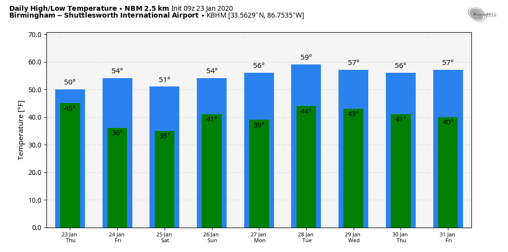
The main rain mass will exit the state very early tomorrow, but clouds will linger through the day. And, as an upper trough swings through, some patches of light rain or drizzle are possible tomorrow afternoon, but nothing like the widespread rain we will deal with today. Temperatures will remain in the 40s over the northern third of Alabama tomorrow, with 50s to the south.
THE ALABAMA WEEKEND: The weekend looks dry for Alabama; with a mix of sun and clouds we expect highs in the 50-55 degree range Saturday and Sunday. Clouds will increase Sunday night with a feature moving through the Gulf of Mexico; this could squeeze out some light rain over far South Alabama early Monday, but moisture will be limited and most likely most of the state will remain dry.
NEXT WEEK: The next rain possibility comes along Wednesday; global models are not in very good agreement concerning the details of the system, but it doesn’t look like a severe weather setup one way or another. More rain is possible by Friday night or Saturday (January 31/February 1). Temperatures through the week will be close to seasonal averages for late January in Alabama with highs mostly in the mid to upper 50s. See the Weather Xtreme video for maps, graphics, and more details.
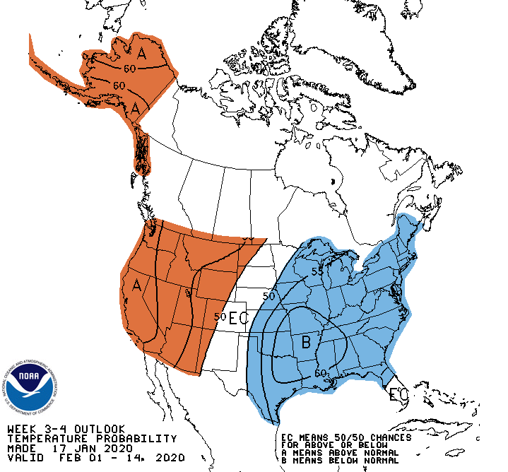
LONG RANGE: We seeing signals of below average temperatures for the eastern and southern U.S. as we get into February based on pattern recognition and teleconnections. Winter is far from over. Below is the CPC outlook for the period February 1-14.
ON THIS DATE IN 2012: An EF-3 tornado tore through Center Point and Clay during the pre-dawn hours, killing one person and injuring many others. A total of 231 homes and businesses were damaged or destroyed. The tornado damage path was approximately 15.5 miles long and was 880 yards wide at its widest point. Earlier that morning, an EF-2 moved through western Jefferson County, killing one person near Oak Grove.
ON THIS DATE IN 1969: An F4 tornado cut a 120-mile long path from Jefferson through Copiah, Simpson, Smith, Scott, and Newton Counties in Mississippi, killing 32 and injuring 241 others. Property damage was estimated at $2 million. An inbound Delta Airlines aircraft reported a hook echo on its scope with this storm.
ON THIS DATE IN 1940: A total of 9.5? of snow fell at Birmingham, in the midst of the city’s longest cold wave. It is the second largest daily snow total on record, surpassed only by the “Blizzard of 93” when 13 inches fell.
BEACH FORECAST: Click here to see the AlabamaWx Beach Forecast Center page.
WEATHER BRAINS: Don’t forget you can listen to our weekly 90 minute show anytime on your favorite podcast app. This is the show all about weather featuring many familiar voices, including our meteorologists here at ABC 33/40.
CONNECT: You can find me on all of the major social networks…
Facebook
Twitter
Instagram
Pinterest
Snapchat: spannwx
I have a weather program this morning at Fayette Elementary… look for the next Weather Xtreme video here by 4:00 this afternoon. Enjoy the day!
Category: Alabama's Weather, ALL POSTS, Weather Xtreme Videos
About the Author (Author Profile)
James Spann is one of the most recognized and trusted television meteorologists in the industry. He holds the AMS CCM designation and television seals from the AMS and NWA. He is a past winner of the Broadcast Meteorologist of the Year from both professional organizations.Subscribe
If you enjoyed this article, subscribe to receive more just like it.


