Tornado Watch Coming Shortly For The Southeastern Parts Of Central Alabama
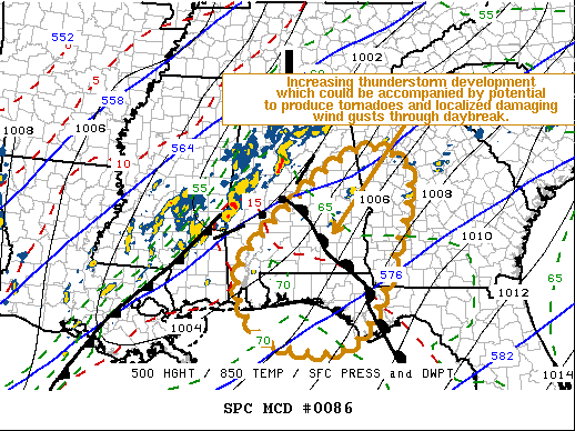
Latest Mesoscale Discussion from the Storm Prediction Center…
SUMMARY
Increasing thunderstorm development is expected through daybreak and beyond, which may be accompanied by increasing potential to produce tornadoes and/or locally damaging wind gusts. A watch probably will be needed within the next couple of hours.
DISCUSSION
Broadly anticyclonic mid-level flow persists across much of the Southeast, but models suggest that a gradual transition toward a cyclonic regime may commence by 12-15Z as far east as the eastern Gulf States, as positively tilted large-scale upstream troughing takes on a more neutral tilt. In response to ongoing embedded short wave developments, elongated surface troughing now approaching the Appalachians is forecast to deepen through daybreak and beyond. By 6:00 am this morning, strongest surface pressure falls may become focused along an axis across southeast Alabama through into the immediate lee of the southern Appalachians. It appears that this will be accompanied by strengthening southerly low-level flow, including within a fairly broad jet around 850 MB (to 50-60+ kt) across much of southern/eastern Alabama, the Florida Panhandle, and Georgia into the western Carolinas.
Where this regime overlies the moist warm sector (characterized by surface dew points of 65-70+ F), an increase in mostly discrete thunderstorm development appears possible initially, aided by forcing for ascent associated with low-level warm advection. A weak warm front currently extending across south central through southeast Alabama has been a focus for enhanced low-level shear and isolated convective development the past few hours. If this boundary persists, models are suggestive that it may shift northeastward ahead of the eastward advancing cold front, and extend along a corridor across east-central Alabama, southward along or just east of the southern Georgia/Alabama state border area by 6:00 am. Regardless, as low-level hodographs enlarge beneath the strengthening 850 MB jet, the environment may become increasingly conducive to supercells which could become capable of producing tornadoes, within the warm sector across southeastern Alabama and the Florida Panhandle.
With regard to the more extensive ongoing convection, aided by forcing along the cold front across southeastern Mississippi into west-central Alabama, and pre-frontal warm advection across north-central/northeast Alabama, activity may tend to become increasingly undercut by cool convective outflow or post-frontal air. As it does any associated severe weather potential probably will diminish.
Category: Alabama's Weather, ALL POSTS, Severe Weather
About the Author (Author Profile)
Scott Martin is an operational meteorologist, professional graphic artist, musician, husband, and father. Not only is Scott a member of the National Weather Association, but he is also the Central Alabama Chapter of the NWA president. Scott is also the co-founder of Racecast Weather, which provides forecasts for many racing series across the USA. He also supplies forecasts for the BassMaster Elite Series events including the BassMaster Classic.Subscribe
If you enjoyed this article, subscribe to receive more just like it.


