EXPIRED – Tornado Warning: Shelby Canceled; Continues For Jefferson & St. Clair Until 3:15 AM
…A TORNADO WARNING REMAINS IN EFFECT UNTIL 315 AM CST FOR EAST
CENTRAL JEFFERSON AND CENTRAL ST. CLAIR COUNTIES…
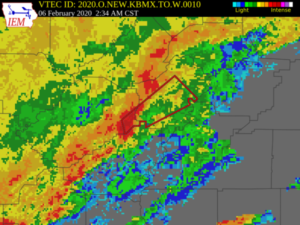
At 231 AM CST, a severe thunderstorm capable of producing a tornado
was located over Moody, moving northeast at 60 mph.
HAZARD…Tornado.
SOURCE…Radar indicated rotation.
IMPACT…Flying debris will be dangerous to those caught without
shelter. Mobile homes will be damaged or destroyed. Damage
to roofs, windows, and vehicles will occur. Tree damage is
likely.
Locations impacted include…
Trussville, Pell City, Leeds, Moody, Springville, Odenville,
Margaret, Argo, Ashville, Ragland, Shops of Grand River, Bald Rock,
Barber Motorsports Park, Branchville, Logan Martin Lake, Wattsville,
Chula Vista and Camp Winnataska.
…THE TORNADO WARNING FOR NORTHEASTERN SHELBY COUNTY IS CANCELED…
The tornadic thunderstorm which prompted the warning has moved out
of the warned area. Therefore, the warning has been canceled.
A Tornado Watch remains in effect until 500 AM CST for central
Alabama.
The National Weather Service in Birmingham has issued a
* Tornado Warning for…
Northeastern Shelby County in central Alabama…
East central Jefferson County in central Alabama…
Central St. Clair County in central Alabama…
* Until 315 AM CST.
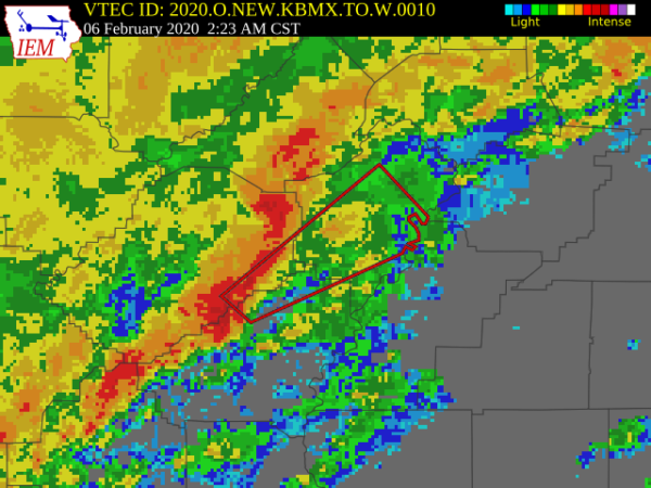
* At 222 AM CST, a severe thunderstorm capable of producing a tornado
was located over Brook Highland, or near Mountain Brook, moving
northeast at 55 mph.
HAZARD…Tornado.
SOURCE…Radar indicated rotation.
IMPACT…Flying debris will be dangerous to those caught without
shelter. Mobile homes will be damaged or destroyed.
Damage to roofs, windows, and vehicles will occur. Tree
damage is likely.
* Locations impacted include…
Vestavia Hills, Mountain Brook, Trussville, Pell City, Irondale,
Leeds, Moody, Springville, Odenville, Margaret, Argo, Ashville,
Riverside, Ragland, Shops of Grand River, Bald Rock, Vandiver,
Barber Motorsports Park, Branchville and Greystone.
PRECAUTIONARY/PREPAREDNESS ACTIONS…
TAKE COVER NOW! Move to a basement or an interior room on the lowest
floor of a sturdy building. Avoid windows. If you are outdoors, in a
mobile home, or in a vehicle, move to the closest substantial shelter
and protect yourself from flying debris.
Category: Alabama's Weather, ALL POSTS, Severe Weather
About the Author (Author Profile)
Scott Martin is an operational meteorologist, professional graphic artist, musician, husband, and father. Not only is Scott a member of the National Weather Association, but he is also the Central Alabama Chapter of the NWA president. Scott is also the co-founder of Racecast Weather, which provides forecasts for many racing series across the USA. He also supplies forecasts for the BassMaster Elite Series events including the BassMaster Classic.Subscribe
If you enjoyed this article, subscribe to receive more just like it.


