Flooding Risk Remains High Tonight
**No afternoon Weather Xtreme video today**
FLOODING CONTINUES: Soaking rains continue to fall across the northern half of Alabama this afternoon, and flash flood warnings remain in effect for at least a dozen counties. A flash flood watch will remain in effect overnight as the big rain event continues to unfold. Some spots have already seen over three inches of rain so far today, and additional amounts of 1-2 inches are likely tonight. Some roads are impassable due to flooding, and if you come across a flooded roadway, remember, TURN AROUND, DON’T DROWN!
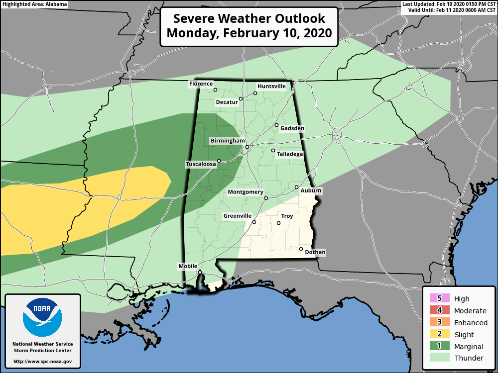
In addition to the flooding issue, SPC maintains a “marginal risk” of severe storms for West Alabama this evening, but the overall severe weather threat is low due to a rain cooled, stable airmass in place.
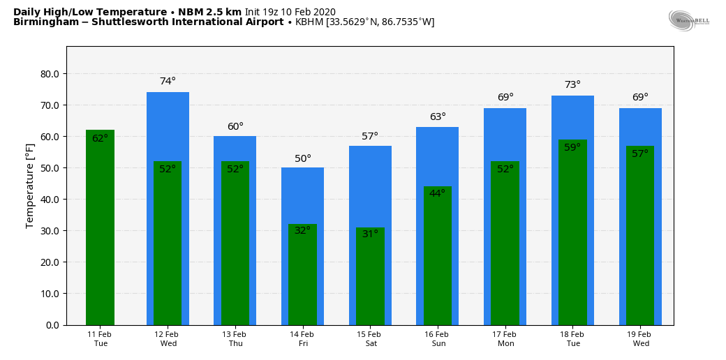
TOMORROW: We will forecast a good chance of occasional showers tomorrow, but the rain won’t be as heavy or as widespread as today. Still, with the soil totally saturated, some flooding issues can’t be ruled out. Of course, most creeks, streams, and rivers across North Alabama will remain out of the their banks. Otherwise, tomorrow will be cloudy with a high in the mid 60s.
SEVERE STORMS POSSIBLE WEDNESDAY NIGHT: The day Wednesday will be mild and breezy, a few showers are possible, and the high will be in the low to mid 70s. An approaching cold front will bring a band of strong to severe thunderstorms into the state Wednesday night and early Thursday… SPC maintains a risk of severe storms for most of the state, including an “enhanced risk” (level 3/5) for a few counties in West Alabama.
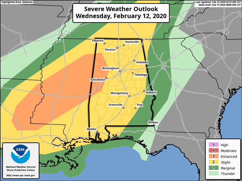
The dynamics look impressive with this system (strong wind fields, etc), but the there are still questions involving the thermodynamics (instability). But, for now, it looks sufficient for a few severe storms from 6:00 p.m. Wednesday through 6:00 a.m. Thursday. Heavier storms will be capable of producing hail, damaging winds, and possibly a few tornadoes. We will be much more specific about this threat tomorrow.
THURSDAY/FRIDAY: Rain ends early in the day Thursday; we could see some clearing by afternoon as drier air works into the state. The high will be in the 50s. Then, Friday will be cold and dry… we start the day in the 27-32 degree range, followed by a high in the upper 40s despite sunshine in full supply.
THE ALABAMA WEEKEND: Saturday looks dry… the sky will be partly sunny with a high in the mid 50s. Clouds increase late in the day, and periods of rain look likely Saturday night into Sunday. Sunday’s high will be in the low 60s.
NEXT WEEK: The weather looks mild and unsettled; some risk of each day at least Monday through Wednesday with highs mostly in the 60s. We could even reach the low 70s on a day or two.
ON THIS DATE IN 1981: A EF-2 tornado moved through Bay Minette, striking the middle school shortly after the school day started. The school’s gymnasium was severely damaged, and 62 people were hurt, 44 of which were students.
BEACH FORECAST: Click here to see the AlabamaWx Beach Forecast Center page.
WEATHER BRAINS: Don’t forget you can listen to our weekly 90 minute show anytime on your favorite podcast app. This is the show all about weather featuring many familiar voices, including our meteorologists here at ABC 33/40.
CONNECT: You can find me on all of the major social networks…
Facebook
Twitter
Instagram
Pinterest
Snapchat: spannwx
Look for the next Weather Xtreme video here by 7:00 a.m. tomorrow….
Category: Alabama's Weather, ALL POSTS
About the Author (Author Profile)
James Spann is one of the most recognized and trusted television meteorologists in the industry. He holds the AMS CCM designation and television seals from the AMS and NWA. He is a past winner of the Broadcast Meteorologist of the Year from both professional organizations.Subscribe
If you enjoyed this article, subscribe to receive more just like it.


