Flash Flooding Remains Probable Over The Next Several Hours
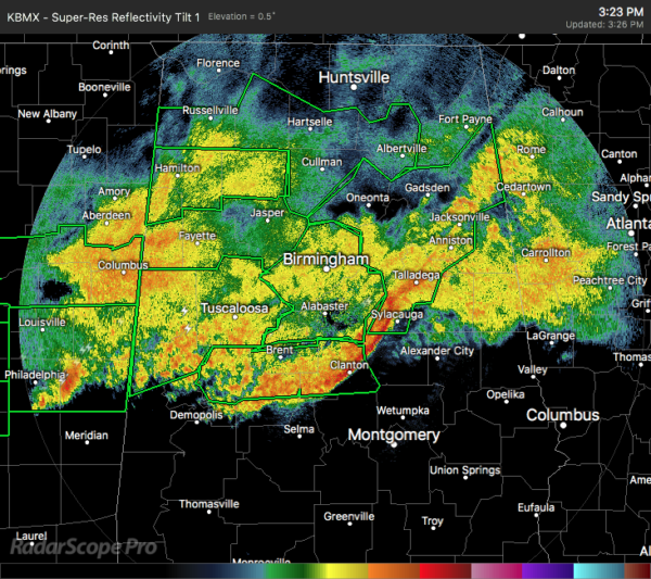
There is no break in the rain for the northern half of Alabama anytime soon, and flooding issues will continue to occur throughout the remainder of the daylight hours and into the evening.
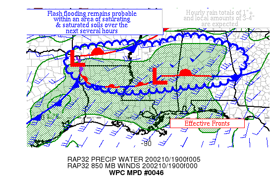
Soils are saturated across portions of MS and AL, with soils continue to saturate in northern LA. Hourly rain totals of 1″+ with additional local amounts to 4″ should lead to flash flooding.
Here is the latest Mesoscale Precipitation Discussion from the WPC…
In-Depth Discussion: Heavy rain continues to fall over sections of northern LA, central MS, and central AL, with hints of forward propagation apparent over MS and AL just ahead of a subtle shortwave moving to the northwest through eastern MO and western AR. It is focused north of an east-west thermal boundary which has been reinforced by today’s thunderstorm activity. Other activity that formed closer to the Louisiana coast is heading northward through the instability pool towards this region. A stronger shortwave is entering northwest TX (southeast of the TX
panhandle) at this time which should keep the heavy rain threat evident for the next several hours as divergence/difluence aloft increases. Precipitable water values are 1.5-1.8″ over much of this area within an atmospheric river. Inflow at 850 hPa is convergent out of the southwest to west-southwest 25-50 kts per VAD wind profiles. Hourly rain totals are highest across central MS and central AL, where 1″+ totals have been indicated by radar.
The guidance indicates that the heaviest rainfall is expected across MS and AL where MU CAPE of 1000+ J/kg is expected to hold on the longest during the next several hours. However, regionally 500+ J/kg of MU CAPE is anticipated through the period per the latest RAP forecasts, which would be sufficient for heavy rainfall within such a saturated air mass. Flash flood guidance values have fallen to next to nothing across portions of MS and AL, so even moderate stratiform in the wake of the convection would be
problematic. Hourly rain totals of 1″+, mostly due to cell training, slowly fade with time per 18z HREF probabilities of such. The guidance indicates local amounts of 3-4″, which seems reasonable. With some of the activity moving back northward, recent HRRR/RAP runs cannot be easily dismissed near the AR/LA border. Considering saturating, if not saturated soils, instances
of flash flooding remain probable into tonight.
Category: Alabama's Weather, ALL POSTS, Severe Weather
About the Author (Author Profile)
Scott Martin is an operational meteorologist, professional graphic artist, musician, husband, and father. Not only is Scott a member of the National Weather Association, but he is also the Central Alabama Chapter of the NWA president. Scott is also the co-founder of Racecast Weather, which provides forecasts for many racing series across the USA. He also supplies forecasts for the BassMaster Elite Series events including the BassMaster Classic.Subscribe
If you enjoyed this article, subscribe to receive more just like it.


