Cloudy, Cooler, Some Light Rain
ON THE MAPS: A cold front has drifted into far South Alabama this morning, but clouds persist statewide, and light rain is falling in the cool air north of the front. Clouds will hang tough through the day, and we will mention the chance of scattered light rain through the afternoon, but the rain won’t be as heavy or as widespread as yesterday. Temperatures won’t get past the 50s over the northern half of the state.
A wave of low pressure forms along the stalled front to the south tonight, and rain will become widespread after midnight tonight into the daytime hours tomorrow. It will be a cold rain; temperatures will hover in the low 40s over North Alabama most of the day. Thermal profiles suggest some light snow is possible over the Tennessee Valley tomorrow morning, especially near the Tennessee state line. But, if snow does fall, we expect little impact with surface temperatures expected to be above freezing. Best chance of any light accumulation on grassy areas will be over southern Tennessee.
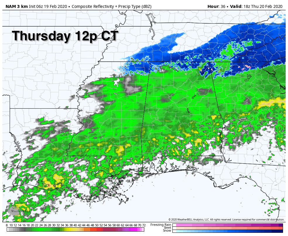
Rain ends late tomorrow, and the sky clears tomorrow night as as nice push of dry air moves into the state. Rain amounts from now through tomorrow night will be around one inch for most of Alabama.
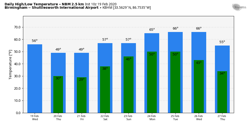
FRIDAY AND THE WEEKEND: Look for sunshine in full supply Saturday and Sunday with cold mornings; lows will be in the 25-32 degree range. The high Friday will be in the upper 40s, followed by upper 50s Saturday. Clouds will slowly increase Sunday, and some rain could reach Alabama Sunday night.
NEXT WEEK: Rain is likely Monday, then on Tuesday the best chance of rain shifts into the southern part of the state. More rain is possible statewide Wednesday, followed by colder and drier air Thursday and Friday. See the Weather Xtreme video for maps, graphics, and more details.
RAIN UPDATE: These are official totals for the month of February so far (from NWS/FAA reporting sites)
Tuscaloosa 13.32″
Birmingham 11.26″
Calera (NWS) 10.67″
Anniston 9.98″
Muscle Shoals 9.74″
Huntsville 8.90″
Montgomery 7.33″
Mobile 4.02″
ON THIS DATE IN 1884: The 1884 Enigma outbreak is thought to be among the largest and most widespread tornado outbreaks in American history, striking on February 19–20, 1884. As the precise number of tornadoes as well as fatalities incurred during the outbreak are unknown, the nickname “Enigma outbreak” has come to be associated with the storm. Nonetheless, an inspection of newspaper reports and governmental studies published in the aftermath reveals tornadoes (or more likely — long-track tornado families) striking Alabama, Georgia, Illinois, Indiana, Kentucky, Mississippi, North Carolina, South Carolina, Tennessee and Virginia, with an estimation of at least 50 tornadoes. One tornado moved from Oxmoor, in what is now the Homewood area, northeast through the Cahaba Valley. Most intense damage was in the industrial area of Leeds, where new, well-constructed homes were destroyed, some of them swept away along with their foundations. This tornado killed 13 people. Another large tornado passed north of Piedmont, near Goshen, killing 30.
BEACH FORECAST: Click here to see the AlabamaWx Beach Forecast Center page.
WEATHER BRAINS: Don’t forget you can listen to our weekly 90 minute show anytime on your favorite podcast app. This is the show all about weather featuring many familiar voices, including our meteorologists here at ABC 33/40.
CONNECT: You can find me on all of the major social networks…
Facebook
Twitter
Instagram
Pinterest
Snapchat: spannwx
I have a weather program this morning at T.R. Simmons Elementary in Jasper… look for the next Weather Xtreme video here by 4:00 this afternoon. Enjoy the day!
Category: Alabama's Weather, ALL POSTS, Weather Xtreme Videos
About the Author (Author Profile)
James Spann is one of the most recognized and trusted television meteorologists in the industry. He holds the AMS CCM designation and television seals from the AMS and NWA. He is a past winner of the Broadcast Meteorologist of the Year from both professional organizations.Subscribe
If you enjoyed this article, subscribe to receive more just like it.


