Colder Tonight; Dry Tomorrow
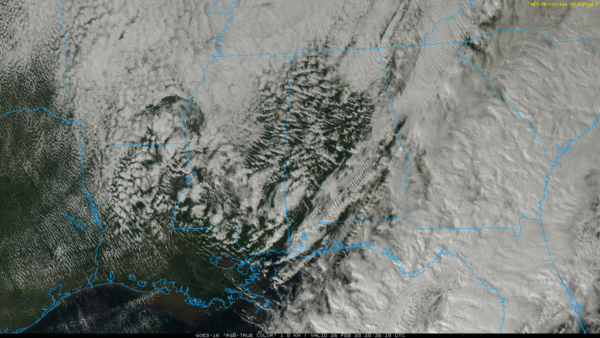
RADAR CHECK: Radar continues to show a few scattered showers across Alabama this afternoon… we are getting a few reports of graupel with those showers as colder air aloft works into the state. Temperatures are mostly in the 40s over North Alabama… the average high for February 26 at Birmingham is 62.
Showers will end this evening, and we will maintain the chance of a few scattered light snow flurries over the northern half of the state tonight, but moisture will be very limited and there won’t be any impact. The sky will become clear after midnight, and temperatures drop into the 27-30 degree range for most communities early tomorrow morning.
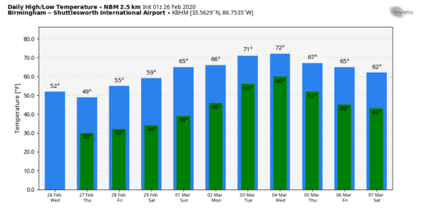
TOMORROW/FRIDAY: Tomorrow will be a sunny day with a high around 50 degrees. The sky will be partly to mostly sunny Friday with a high in the mid 50s; a clipper will bring some risk of light rain or snow flurries to the northeast corner of the state Friday night. Again, moisture will be very limited, and we expect no impact.
THE ALABAMA WEEKEND: Look for a good supply of sunshine Saturday and Sunday. After a low in the 32-35 degree range Saturday, the high will be in the mid to upper 50s. Then, on Sunday, we rise into the mid 60s.
NEXT WEEK: Monday and Tuesday will be mostly cloudy and mild with a few showers possible. We will see a high around 70 Monday, followed by low 70s Tuesday. Rain and storms become widespread Tuesday night into part of the day Wednesday… too early to know if we will have any severe weather risk, but something to watch in coming days. Drier air returns for the latter half of the week. See the Weather Xtreme video for maps, graphics, and more details.
ON THIS DATE IN 1972: The Buffalo Creek disaster occurred in the Buffalo Creek Hollow of Logan County in West Virginia. A coal slag dam on the Middle Fork of Buffalo Creek burst, sending a fifty-foot wall of water down a narrow valley killing 125 persons and causing 51 million dollars damage. Three days of rain atop a six-inch snow cover caused the dam to break.
ON THIS DATE IN 2008: A long-lived windstorm produced by severe thunderstorms, known as a derecho, caused a widespread swath of damage across Central Alabama during the early morning hours. Although there were some sporadic reports of light tree damage and small hail west of Interstate 65, a more intense and widespread swath of damage started in southern Jefferson and northern Shelby Counties between 3:30 am and 4:00 am. From there, the damage swath moved eastward, roughly parallel to Interstate 20, reaching the Georgia border by 5:00 am. Thunderstorm wind gusts estimated at 60 to 70 mph were widespread in this damage swath, with occasional hurricane force peak wind gusts, estimated just over 100 mph in some areas. In addition to widespread severe thunderstorm wind damage… three EF-1 tornadoes touched down across Central Alabama.
BEACH FORECAST: Click here to see the AlabamaWx Beach Forecast Center page.
WEATHER BRAINS: Don’t forget you can listen to our weekly 90 minute show anytime on your favorite podcast app. This is the show all about weather featuring many familiar voices, including our meteorologists here at ABC 33/40.
CONNECT: You can find me on all of the major social networks…
Facebook
Twitter
Instagram
Pinterest
Snapchat: spannwx
I enjoyed seeing the third graders today at Centre Elementary… be looking for them on the Pepsi KIDCAM today at 5:00 on ABC 33/40 News! The next Weather Xtreme video will be posted here by 7:00 a.m. tomorrow…
Category: Alabama's Weather, ALL POSTS, Weather Xtreme Videos


