Strong/Severe Storms Continue To Move Through The Southern Parts Of The Area
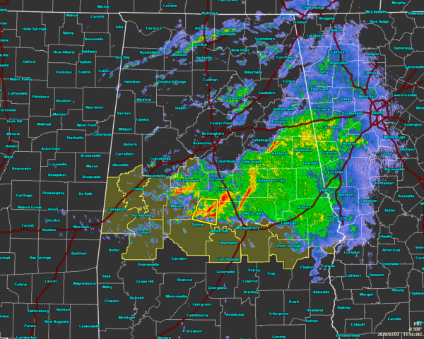
As of 7:15 am, we continue to have stronger to severe thunderstorms moving eastward across the southern portions of Central Alabama this morning. A severe thunderstorm warning is currently in effect until 7:45 am this morning for Autauga, Chilton, and Dallas counties as there is potential for damaging winds and hail up to 1 inch in diameter. The rest of this activity is putting down moderate to heavy rainfall especially from Sylacauga down to Prattville and back to Clanton, Billingsley, and just north of Selma.
A Tornado Watch continues until 11:00 am for Autauga, Bibb, Bullock, Chambers, Chilton, Clay, Coosa, Dallas, Elmore, Hale, Lee, Lowndes, Macon, Marengo, Montgomery, Perry, Randolph, Russell, and Tallapoosa counties.
There are scattered showers and thunderstorms up in North Alabama as well that is putting down moderate to heavy rainfall, but these are well below severe limits at this time.
The severe threat looks to continue through the rest of the morning hours and into the early afternoon hours, coming to an end around 2:00 pm. We’ll keep you updated throughout the day.
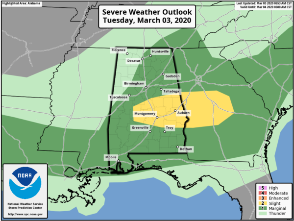
Much of the area remains in a Marginal Risk for severe storms while a Slight Risk was recently introduced for the southern and southeastern parts of the area for today.
Category: ALL POSTS
About the Author (Author Profile)
Scott Martin is an operational meteorologist, professional graphic artist, musician, husband, and father. Not only is Scott a member of the National Weather Association, but he is also the Central Alabama Chapter of the NWA president. Scott is also the co-founder of Racecast Weather, which provides forecasts for many racing series across the USA. He also supplies forecasts for the BassMaster Elite Series events including the BassMaster Classic.Subscribe
If you enjoyed this article, subscribe to receive more just like it.


