SPC Mesoscale Discussion: Severe Threat Continues For Central Alabama
The severe weather threat for Tornado Watch 38 continues.
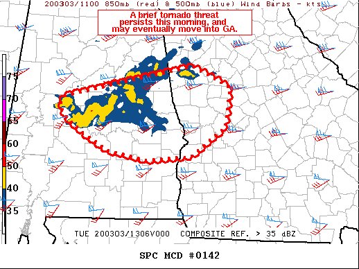
SUMMARY…A cluster of storms may continue to pose a tornado or damaging wind threat over the next several hours from central Alabama into west-central Georgia.
DISCUSSION…A slow-developing, but long-lived cluster of storms continues to sporadically pose a tornado risk over central Alabama this morning. These storms formed in association with warm/moist advection, and persist with the aid of substantial deep-layer wind shear and sufficient instability. 12Z soundings from the region suggest MLCAPE on the order of 500 J/kg. Objective analysis further indicates that instability decreases south of the area as temperatures aloft are warmer. However, pockets of heating may eventually develop later this morning and aid destabilization. Effective SRH over 200 m2/s2 is also forecast to remain for much of the day. As such, a brief tornado or damaging wind gusts remain possible within this east-west corridor.
Category: Alabama's Weather, ALL POSTS, Severe Weather
About the Author (Author Profile)
Scott Martin is an operational meteorologist, professional graphic artist, musician, husband, and father. Not only is Scott a member of the National Weather Association, but he is also the Central Alabama Chapter of the NWA president. Scott is also the co-founder of Racecast Weather, which provides forecasts for many racing series across the USA. He also supplies forecasts for the BassMaster Elite Series events including the BassMaster Classic.Subscribe
If you enjoyed this article, subscribe to receive more just like it.


