Strong Storms Rolling Into The Birmingham Metropolitan Area
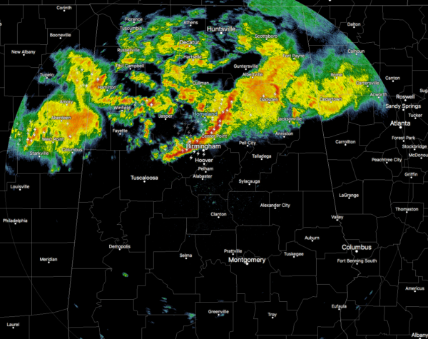
Rain and thunderstorms continue to move across the northern half of Central Alabama and up into North Alabama as of 6:20 am. The strongest storms were moving through Blount and Jefferson County and were entering Downtown Birmingham as I type this post. Gusty winds and small hail can be expected with a brief shot of heavy rainfall and a good bit of lightning.
Movement of these storms were to the east at 50 MPH.
The following locations will need to move indoors until these storms pass by: Birmingham, Hoover, Vestavia Hills, Bessemer, Homewood, Mountain Brook, Trussville, Hueytown, Gardendale, Irondale, Leeds, Moody, Fultondale, Center Point, Pleasant Grove, Clay, Pinson, and Tarrant.
The rest of the activity is well less than severe at this point, but you could still expect some lightning and moderate to heavy rain at times.
Category: Alabama's Weather, ALL POSTS, Severe Weather
About the Author (Author Profile)
Scott Martin is an operational meteorologist, professional graphic artist, musician, husband, and father. Not only is Scott a member of the National Weather Association, but he is also the Central Alabama Chapter of the NWA president. Scott is also the co-founder of Racecast Weather, which provides forecasts for many racing series across the USA. He also supplies forecasts for the BassMaster Elite Series events including the BassMaster Classic.Subscribe
If you enjoyed this article, subscribe to receive more just like it.


